




Drones save more than just lives for backcountry search and rescue teams

Guest article written by Anna DeBattiste; Colorado Search and Rescue Association (Check out our podcast with Anna on Apple or Spotify to learn more about search and rescue in Colorado)
The days of UAV technology being used only to search for missing people in the backcountry have long been surpassed. Backcountry search and rescue (BSAR) organizations in Colorado are reporting a wide range of uses these days, with an even wider range of future possibilities.
Recently, a group of drone pilots on Colorado BSAR teams banded together to share ideas, trade technical tips, draw lessons from incident summaries, and discuss other ways to collaborate and learn. Program volunteers from the Colorado Search and Rescue Association (CSAR) talked to several of the pilots to see how we might support the efforts, and in the process, we heard interesting stories about how drones are being used not only to save lives in the backcountry, but also to save risk, time and effort for the volunteer rescuers.
Search
Searching the backcountry for a missing person still remains a frequent use of UAVs in BSAR, but according to Darren Keralla of Douglas County Search and Rescue, some teams are moving away from simple “fly and find” activities to more use of AI analysis, using software such as Eagle Eyes to detect color and motion anomalies in terrain, Loc8 (pronounced “locate”), a pixel forensic software, to pick up certain colors, or thermal imaging software to detect heat signatures.
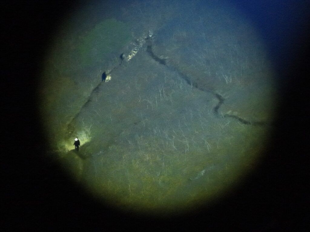
For example, Vail Mountain Rescue Group flew a drone to look for a missing subject on a river at night, using thermal imaging to detect the difference between the temperature of the paddleboard and the temperature of the river. Douglas County SAR says during a search in which they were using Loc8 to find the blue clothing of the subject, the software was so powerful it picked up the blue on a deputy’s flag pin from hundreds of feet up. Mesa County Search and Rescue describes using thermal imagery to find a shelter dog named Aphrodite that had run away after a driver stopped to clean out his cage in Fruita. But Mesa also says that thermal imagery technology has its limitations – the heat of the rocks in their county’s canyonland terrain can make a search turn into a needle-in-a-haystack situation.
Reducing Risk
Custer County Search and Rescue UAV team lead Jamie Foote says he proposed starting a drone team because of the extremely technical terrain the team works in when searching for and rescuing climbers in the Crestones. “We believe the lives we save are going to be our own,” he says. Many Crestone rescues happen because a climber has gotten off route or been injured in one of the many dangerous couloirs in these mountains, and drones can help with finding the subject, scouting a safer route, avoiding putting a rescuer at risk from rockfall, and lighting up a rescuer’s downclimb.
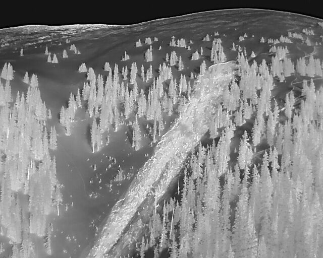
In Summit County, where avalanche calls are frequent, the special operations technicians of the Summit County Sheriff’s Office have been flying drones on SAR calls for years to support Summit County Rescue Group. When an avalanche is reported and it is uncertain whether someone is buried or not, the spec ops unit will fly a drone low over the debris to look for tracks in but not out, items of clothing or equipment that may have come from someone caught in the slide, or anything else that might indicate whether a person is buried. On Loveland Pass, a popular backcountry ski location that often slides, the spec ops team will send someone to stand on the road with binoculars, but they sometimes pick up objects that can’t be clearly distinguished. By flying a drone, they might discover that what looks like human tracks is actually animal tracks. Special Operations Technician SJ Hamit tells the story of a truck that was swept off Loveland Pass in an avalanche and tumbled 300 feet. Avalanche danger was so high that no one wanted to take the risk of going into the debris field to see if there was someone inside needing help. Using a drone, SJ was able to pick up the truck’s license plate and call the owner, which led to confirmation that the driver (a family member) had extricated himself and was safe and sound.
In Mesa County, UAV team members Lizzie Depew and Ron Rennke say the route-finding capabilities of drones help reduce risk for rescuers in canyons or on steep, rocky mountains, especially when a subject is “cliffed out” (stranded) on technical terrain. Using a location-based service application called COTAK, they can even livestream a preferred route to the entire team.
They once used a drone to find a cliffed-out subject at night, hidden below the top of a 300-foot vertical face and under a rock shelf, invisible to the tech rescuers above. The drone used thermal imaging and night vision to locate the subject and hover under the rock shelf to guide the team’s tech to the subject and determine a route for extraction.
Reducing Volunteer Time and Effort
Scouting terrain and finding time-saving and safer routes in or out of the field is a key capability of UAVs. Is there deep snow, deadfall, rock faces too difficult to scale? Is one route more efficient than another? Using a drone to figure out whether a team has to respond at all is also a time-saving feature.
Vail Mountain Rescue Group tells the story of a group of snowmobilers on Shrine Pass who called to say they were stuck. The team flew a drone to their location coordinates and found that they were already gone, having extricated themselves, so the team never needed to deploy anyone on the ground. Vail is also called for many searches, rescues and recoveries on the Colorado River. Because a subject on the river is constantly moving quickly down the river, searches on foot can be extremely time consuming. The team now keeps small drones that can fly directly from a raft, as well as larger drones that fly from the incident command post to provide superior imaging technology during a search. UAV team lead Brent Cartwright tells the story of a life saved when an elderly rancher went missing near State Bridge and the team thought they had a pretty good idea of the area to search. A drone found him in a different area within four or five minutes, saving a lot of volunteer time and effort. He had fallen into the river and was exhausted, and with temperatures heading below freezing that evening, he likely would not have survived if the drone hadn’t found him so quickly.
In Custer County, the team has a very long trip to get into the Crestones – at least four hours of combined hiking and driving. Medevac helicopters will take them when weather permits, but otherwise, they risk being pretty tired by the time the climbing even begins. Drones help by doing searches that may lead to the team never having to deploy at all. Drones can also search a vertical rock face that is difficult and even dangerous for a helicopter to do at the speed it is flying. A drone recently saved the team from the challenging and unpleasant job of searching a marshland for a body. And with 700 square miles in the county and only 40 team members, the team expects drones will be tremendously helpful next time they have a search for a walkaway (a subject with cognitive impairment who wanders away and is reported missing).
In Summit County, the spec ops team once flew a drone for three hours to guide a lost skier back to the parking lot at night, saving the team from a long and cold hike to get to him and then escort him out.
Communication and Supplies for Subjects
Drones have been used to communicate with rescue subjects, either by a one-way loudspeaker or by dropping radios to them. They’ve also been used to drop lifesaving supplies to a subject, or to shuttle equipment for rescuers, such as taking a line across a river.
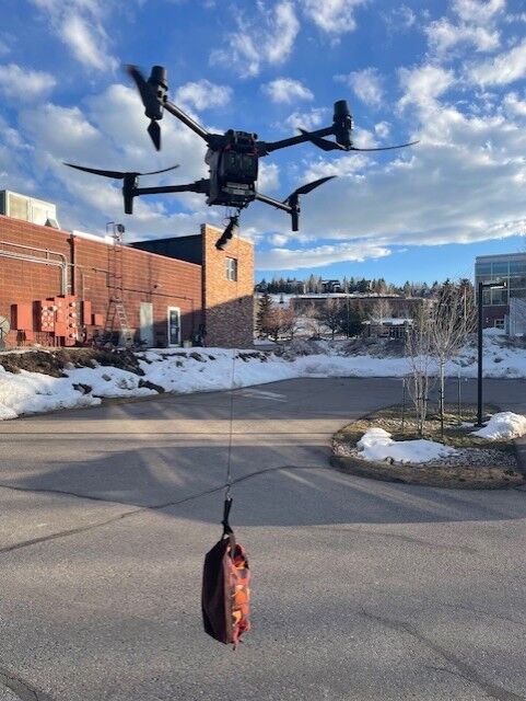
In a high profile incident in December of 2024, Douglas County Search and Rescue flew a drone to find a ten-year-old boy who had been missing on his ATV for hours. They used a loudspeaker on the drone to ask the boy to signal whether he was OK, and then to drop a care package of food and water to him. “The communication capability can be comforting to both rescuers and rescue subjects,” Darren Keralla comments. “People often thank me for having ‘eyes in the sky.’” In March of 2025, Douglas County SAR used the drone’s loudspeaker to let a worried family member send words of encouragement to two missing teenagers in Roxborough State Park whom the team had just found.
Drones with loudspeakers can be pre-programmed with canned messages for common situations, such as, “Are you hurt? Raise your right hand if you’re injured.” Vail Mountain Rescue Group recently had a search for a subject who spoke only Spanish, and they are now revamping their capabilities to have pre-programmed messages in Spanish.
In Summit County in 2025, the sheriff’s office received a report that a young girl had had a seizure at school and was in the ICU, and her father was hunting in the Acorn Creek area with no cell service. SJ Hamit flew a drone with a loudspeaker and notified the father, who immediately hiked out and sped to the hospital. On a recent call in 2026, a winter hiker on Quandary Peak reported that he was lost and possibly off-trail, and now was out after dark with no source of light. A drone dropped a flashlight to him, enabling him to find his way back to the trail.
In a relatively new and impressive use of specialized UAV equipment, Mesa County SAR sourced a heavy lift drone called a FlyCart 30 from a research and development branch of the Colorado Department of Public Safety. They were trying to recover a body from the side of Mount Garfield, and the terrain was so steep, rocky and dangerous that they were using ice tools and crampons to ascend, despite it being summer. Only three rescuers were sent up, to reduce danger from rockfall, and it was not possible for them to carry all the gear needed for the recovery. They used the drone to fly up a litter, rigging equipment, a 600-foot rope, and Gatorade and food for the rescuers, who had already been in the field for seven hours in high temperatures.
Situational Awareness and Scene Size-up for Incident Commanders
Having eyes on a scene can help incident commanders tremendously, giving them nuances that radio communication cannot and helping them make speedier or more effective decisions. Teams had many examples to give.
In Douglas County, the team used live footage from a drone to see that a missing subject who had just been found was stumbling and looked like he needed medical attention. They ordered medical resources into the field right away. In another incident, they saw that an injured dirt biker was shivering and was likely in shock, so they were able to send in a helicopter for a faster response. Responding to a climber fall, they used a drone to measure from the top of the cliff to where the climber was so the technical team would know how much rope to bring into the field. In the most dramatic example from Douglas County SAR, the UAS team used live footage to reassure a fire chief when a firefighter was seriously injured in an ATV rollover while responding to a call. The fire chief could see that his responder was still breathing.
Vail Mountain Rescue Group once saw via drone footage that a missing subject had a dog with him that looked agitated. They were able to warn the ground team to be careful around the dog. They also used drone footage to help a county coroner with a death investigation for an incident that happened in very remote terrain. “Hasty teams can use a drone to fly into a scene and start looking around on any incident,” Brent Cartwright says, “and that can help them determine whether specialized equipment is needed, among other things.” The team has found drones useful in so many ways that in addition to their river drones that go out on rafts, they also bought a water resistant drone to put on the back of snowmobiles, and a lightweight drone to put in a backpack to carry up Mount Holy Cross.
In Summit County, an avalanche on Mount Baldy was scouted by a Flight for Life helicopter and the pilot reported that from his height, the slide did not look big enough to have buried someone. Technician Joe Scalise from the special ops team flew a drone at a lower altitude than the helicopter could fly and came to a different conclusion. Summit County Rescue Group sent a team of skiers into the field that night, and the team was able to find and recover the body of a deceased skier who’d been caught and carried.
Is there anything the public can learn about drone use to contribute to their safety? Keralla says backcountry recreationists should think about what colors they wear, and how visible they are from the air once they find themselves lost or injured. “We’re reluctant to use our Loc8 software if someone is wearing black,” he says, “because Loc8 looks for unnatural colors in a natural environment.” Wearing bright colors will also help any pilot searching manually, whether a drone pilot or a helicopter pilot. And if you’re awaiting a rescue, think about line of sight – get out from under that tree and position yourself in a clearing or on a trail. “In the field, both the human eye and our detection software, Eagle Eyes, are optimized to detect movement,” Keralla adds. “During drone operations, even small, deliberate motion can be the difference between blending into the environment and being spotted quickly.” If you know a drone is overhead and you’re able, wave, signal, or shift position to create contrast and movement. If you’re injured or can’t move much, use whatever you can – an arm, a hand, clothing, a light, or reflective gear – to create small visual cues. Even minimal motion can significantly improve your chances of detection and speed up your rescue.
STAY INFORMED: Get free Colorado news with our daily newsletter (Click here)
Get OutThere
Signup today for free and be the first to get notified on new updates.
PREV
PREVIOUS
Winds hit 111 MPH at two popular Colorado ski areas
As was expected, big winds hit Colorado over the weekend, reaching into the triple-digits in some places. Per National Weather Service reporting, the Parsenn Bowl summit found at about 12,060 feet of elevation is where some of the strongest gusts were present, measured at 111 miles per hour around 1 a.m. on March 15. Skiers […]
Did Colorado's snowpack peak a month early at a record low? Some signs point to 'yes'
Has Colorado’s snowpack peak already come and gone? Maybe – and if so, it would be the earliest snowpack peak on record with records dating back to 1987. Those who have been following along with the state’s snowpack since the start of the season already know that the winter of 2025-2026 has brought record-setting dryness […]