


11 ‘inconvenient’ drives around Colorado: Travel between towns 9 miles apart means 2 hours on road
Colorado’s mountainous landscape sure is stunning, but all those massive peaks make it pretty inconvenient from time to time when it comes to connecting the many cities and towns that dot the state. While transportation engineers may plan a route to travel over or under a formidable peak, the best option is sometimes to simply go around it via a lengthy drive.
As might be expected, the move to circumvent Colorado’s natural obstacles when planning roads results in towns that are separated by only a few miles requiring hours of travel when visiting both.
In order to determine which travel routes around Colorado were the ‘most inconvenient,’ I took several factors into consideration – geodesic distance between two towns (distance between towns ‘as a crow flies,’ ignoring elevation changes), how long the quickest driving route takes, and how many miles the quickest route covers, all with the help of Google Maps.
For example, travel between Colorado Springs and Denver is extremely convenient. The cities are separated by 63 miles, but traveling between them only takes 75 minutes on a 71-mile route. This means that a driver is traveling 1.19 minutes and 1.13 miles per mile of geodesic separation. The same can be said for the drive between Denver and Grand Junction – slightly less efficient, but in the same ballpark with drivers traveling 1.22 minutes and 1.26 miles per mile of geodesic separation.
Even long routes across the state’s mountains are relatively efficient – Denverites headed to Telluride might be traveling more than six hours, but they’re still covering driving about 1.89 minutes and traveling 1.69 miles per mile of separation considering that the geodesic distance between these towns is 331 miles.
The drive between many smaller towns around the state is rarely a straight shot, though, with some drives meaning about 13 minutes on the road per every mile of geodesic separation – a bit of a hassle, indeed.
With that in mind and without further ado, here’s a look at 11 of the ‘most inconvenient drives’ in Colorado:
Note from the author: These are ordered in ‘travel miles per geodesic miles’ as distance doesn’t change, but travel time can. It’s also worth noting that this report is based on Google Maps recommendations, which favors major roads. In cases where multiple routes were present, the route with the shortest travel time was selected as this felt like the most realistic option one would pick.
11. Creede to Ophir
Geodesic separation: 50 miles
Drive time: 255 minutes
Drive length: 225 miles
Minutes per geodesic mile: 5.10
Travel miles per geodesic mile: 4.50
10. Fairplay and Leadville
Geodesic separation: 15 miles
Drive time: 75 minutes
Drive length: 72 miles
Minutes per geodesic mile: 5 minutes
Travel miles per geodesic mile: 4.80 miles
9. Mount Crested Butte to Aspen
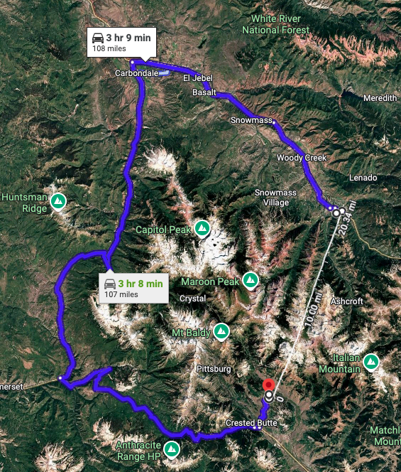
Geodesic separation: 20 miles
Drive time: 189 minutes
Drive length: 108 miles
Minutes per geodesic mile: 9.45 minutes
Travel miles per geodesic mile: 5.40 miles
8. Lake City to Ophir
Geodesic separation: 30 miles
Drive time: 200 minutes
Drive length: 171 miles
Minutes per geodesic mile: 6.67 minutes
Travel miles per geodesic mile: 5.70 miles
7. Eldora Mountain Resort to Winter Park
Geodesic separation: 11 miles
Drive time: 97 minutes
Drive length: 69 miles
Minutes per geodesic mile: 8.82 minutes
Travel miles per geodesic mile: 6.27 miles
6. Westcliffe and Crestone
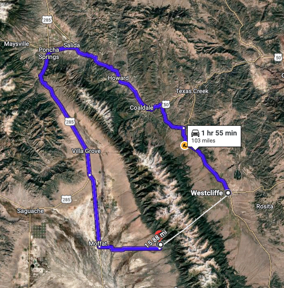
Geodesic separation: 16 miles
Drive time: 120 minutes
Drive length: 103 miles
Minutes per geodesic mile: 7.50 minutes
Travel miles per geodesic mile: 6.44 miles
5. Lake City to Silverton
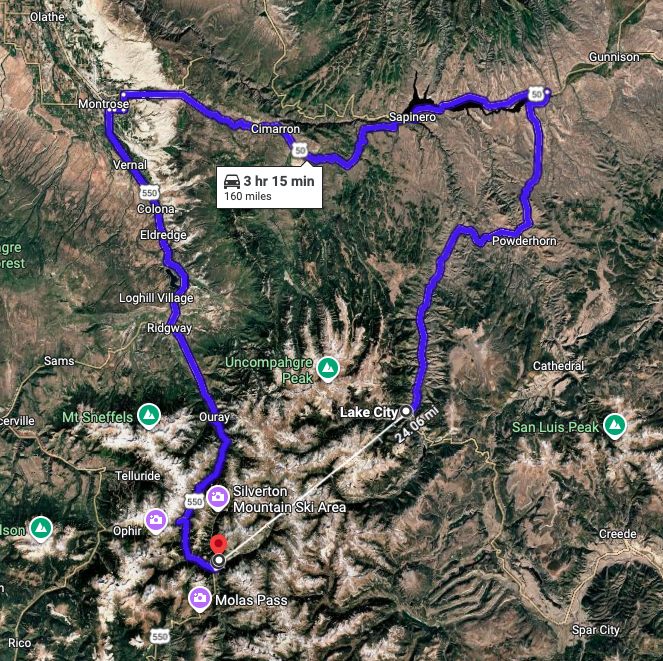
Geodesic separation: 24 miles
Drive time: 195 minutes
Drive length: 160 miles
Minutes per geodesic mile: 8.13 minutes
Travel miles per geodesic mile: 6.67 miles
4. Lake City and Ouray
Geodesic separation: 19 miles
Drive time: 150 minutes
Drive length: 136 miles
Minutes per geodesic mile: 7.89 minutes
Travel miles per geodesic mile: 7.16 miles
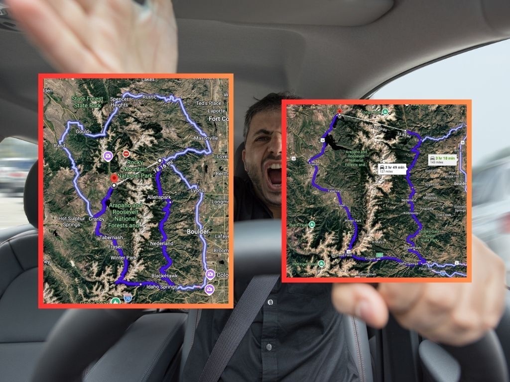
3. Estes Park and Grand Lake (avoiding seasonal Trail Ridge Road)
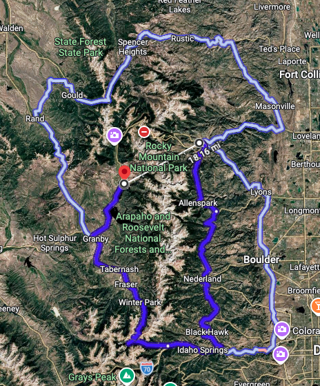
Geodesic separation: 18 miles
Drive time: 195 minutes
Drive length: 136 miles
Minutes per geodesic mile: 10.83 minutes
Travel miles per geodesic mile: 7.56 miles
2. Allenspark and Grand Lake
Geodesic separation: 16 miles
Drive time: 169 minutes
Drive length: 127 miles
Minutes per geodesic mile: 10.56 minutes
Travel miles per geodesic mile: 7.94 miles
1. Silverton to Ophir
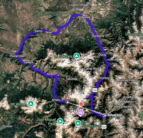
Geodesic separation: 9.5 miles
Drive time: 120 minutes
Drive length: 79 miles
Minutes per geodesic mile: 12.63 minutes
Travel miles per geodesic mile: 8.32 miles
In other words, if someone was able to travel the nine and a half miles between Silverton and Ophir on foot at a pace of about 12 minutes and 37 seconds, that would be enough to beat a vehicle traveling between these two towns. Obviously, the terrain in this area is treacherous and there’s not a perfectly straight trail between the two, so don’t expect that to happen any time soon.
While traveling around Colorado might be a bit ‘inconvenient’ at times, thankfully, all of these routes come with stunning scenic views along the way.
STAY INFORMED: Get free Colorado news with our daily newsletter (Click here)
Get OutThere
Signup today for free and be the first to get notified on new updates.
PREV
PREVIOUS

Health officials warn of potential measles exposure at sports bar in Colorado
Colorado health officials have made the public aware of a possible measles exposure that took place at a popular Arvada sports bar. According to the Colorado Department of Public Health and Environment and Broomfield Public Health and Environment, the place of potential exposure was Bout Time Pub & Grub on W. 80th Avenue. Potential exposure […]
Mandatory evacuations still underway for one of 3 wildfires burning in southern Colorado
Containment of a fire that prompted mandatory evacuations while threatening close to 100 structures has increased in recent hours, per an update from the Custer County Sheriff’s Office. Dubbed the Buttermilk fire, the blaze sparked on Wednesday in rugged terrain found west of Highway 69’s stretch between Hillside and Westcliffe. At last report, it had […]