




Hailstorm pummels downtown Denver; storm cancels flights, floods interstate
Significant flooding closed portions of I-25 in Denver
A hailstorm hit downtown Denver on Thursday, bringing with it a torrent of rain that forced commuters and motorists to seek shelter.
Once the storm passed, heavy traffic clogged the city’s major streets.
Hail, heavy rain, fog and street flooding was reported across the Denver metro area mid-afternoon Thursday.
“Quite a few reports of flooding in and around Denver, including on area interstates. Avoid the roads if you can as this storm moves through!” the NWS Boulder office posted.
Heavy rain washed dirt and debris onto southbound I-25 at 23rd Avenue in Denver, closing two of the lanes. CDOT crews were using plows to clear the debris Thursday evening.
Denver Gazette media partner 9News also reported flooding on eastbound Interstate 70 under Federal Avenue.
A submerged vehicle near West 38th Avenue and Fox Street sent Denver Fire Department Dive crews into the water to confirm that no one was stuck inside the car.
The stormy weather also delayed the game between the Los Angeles Dodgers and Colorado Rockies by two hours.
Videos of a hail-covered Coors Field circulated on Twitter, including one of Rockies catcher Elias Diaz making hail angels.
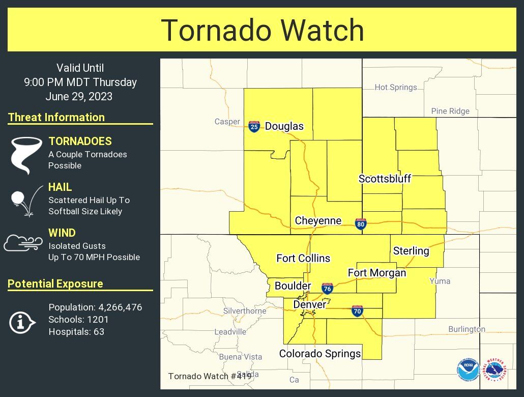
The National Weather Service on Thursday had issued a flash flood warning for Lakewood, Wheat Ridge, and Edgewater until 6 p.m., which followed an earlier tornado watch for the Denver metro area that extended into northeastern Colorado and parts of Wyoming and Nebraska effective until 9 p.m.
An severe thunderstorm warning was posted by the NWS for Aurora, Denver International Airport, Bennett and Watkins.
Denver’s airport had 738 delays and 181 cancellations as of 6:30 p.m., according to the flight tracking service FlightAware.com. The site reported 83 canceled flights and nearly 400 delays from DIA by 6:30 p.m. In addition, nearly 100 flights to Denver were canceled, as well 350 delays.
Chris Bianchi, a meteorologist for 9News, reported that nearly 2 inches of rain fell on Lakewood in an hour.
The tornado watch issued includes 13 Colorado counties: Adams, Arapahoe, Boulder, Broomfield, Denver, Douglas, Elbert, Jefferson, Larimer, Logan, Morgan, Washington and Weld.
A “tornado watch” means conditions are such that a tornado could form, which is different from a “tornado warning,” which means a tornado has been spotted or rotation has been seen on radar.
The National Weather Service said the strongest storms over Colorado on Thursday could have produced baseball-size hail and 70 mph gusts. Flash flooding was also a threat mainly in Morgan in Logan counties due to heavy rain, the weather service said.
Denver expected to see rain and mild temperatures on Thursday, with highs in the 70s heading into the weekend, according to the National Weather Service.
A hazardous weather outlook had been established for the city and surrounding areas due to the possibility of heavy rainfall, high winds, and hail.
“Scattered thunderstorms will develop over and near the Front Range this afternoon, and move onto the plains in the late afternoon and evening. The strongest storms could produce hail up to tennis ball size and wind gusts to 70 mph. A few tornados are also possible,” the weather service said in its forecast.
Here’s the full forecast from the National Weather Service:
Friday: There’s an 80% chance of afternoon showers and thunderstorms. Expect a high of 73 degrees.
Saturday: There’s a 20% chance of showers and thunderstorms heading into the afternoon. Expect mostly cloudy skies and a high near 80 degrees.
Sunday: There’s a 30% chance of showers and thunderstorms in the afternoon. Expect mostly sunny skies and a high near 86 degrees.
Monday: Expect sunny skies and a high near 89 degrees.
Tuesday (Fourth of July): There’s a slight chance of showers and thunderstorms. Expect partly sunny skies and a high near 87 degrees.

Get OutThere
Signup today for free and be the first to get notified on new updates.
PREV
PREVIOUS

June 30 is Blink-182 Day; Colorado's connection to the band
Known nationally as a band that runs naked in their music videos, marrying Kardashians and making cameos in movies — June 30, the 182nd day of the year — is known colloquially as Blink-182 day. But Coloradans have a storied history with the band. Most recently the band’s music has been pumping over the loud […]

The great work begins: Ellen McLaughlin embraces the madness of 'King Lear' | John Moore
Colorado Shakespeare Festival explores quintessential patriarch's dance with dementia through the vessel of a woman in Boulder