


Above the clouds on a frozen hike to Colorado’s Sky Pond at 10,900 feet
Tucked away in the heart of Rocky Mountain National Park, the snow-filled winter route to Sky Pond is not a trek for the inexperienced hiker. A destination found at the end of a trail that passes expansive scenes of frozen lakes and icy waterfalls, those embarking on this adventure should proceed with extreme caution and be prepared to face off with cold weather hazards.
In search of a beautiful scene during the middle of the pandemic in January of 2021, I found my sights set on Sky Pond trail thanks to its final destination – jagged rocks stretched high above the frozen surface of a lake in the alpine terrain of Colorado’s most popular national park.
Aware of the risks that came with it, I carefully picked the ‘right’ day to hit the trail. I knew cold weather would be present, including a sub-zero windchill, but forecasted blue skies and lack of recent snow would make trail finding easier – or so I hoped. While Sky Pond is a highly-trafficked route during summer months, I would soon find out that it’s far less-trafficked in the winter, perhaps rightfully so.
The standard route to Sky Pond starts at Rocky Mountain National Park’s Glacier Gorge Trailhead, clocking in at about 9 miles round-trip with close to 1,800 feet of vertical gain. This is also where popular spots such as Bear Lake, Alberta Falls, and The Loch are be reached, making an early arrival advised as parking is often limited.
The first portion of the Sky Pond hike via Glacier Gorge Trail leads to ‘The Loch’ found at about 10,000 feet of elevation, while also passing Alberta Falls along the way. On the day I hit the trail, this portion of the route was covered in hard-packed snow and easy to follow, 2.7 miles in length one-way. This portion of the trail was also much more trafficked than the remainder of the hike that would follow, with few people encountered past this point for the rest of the day.
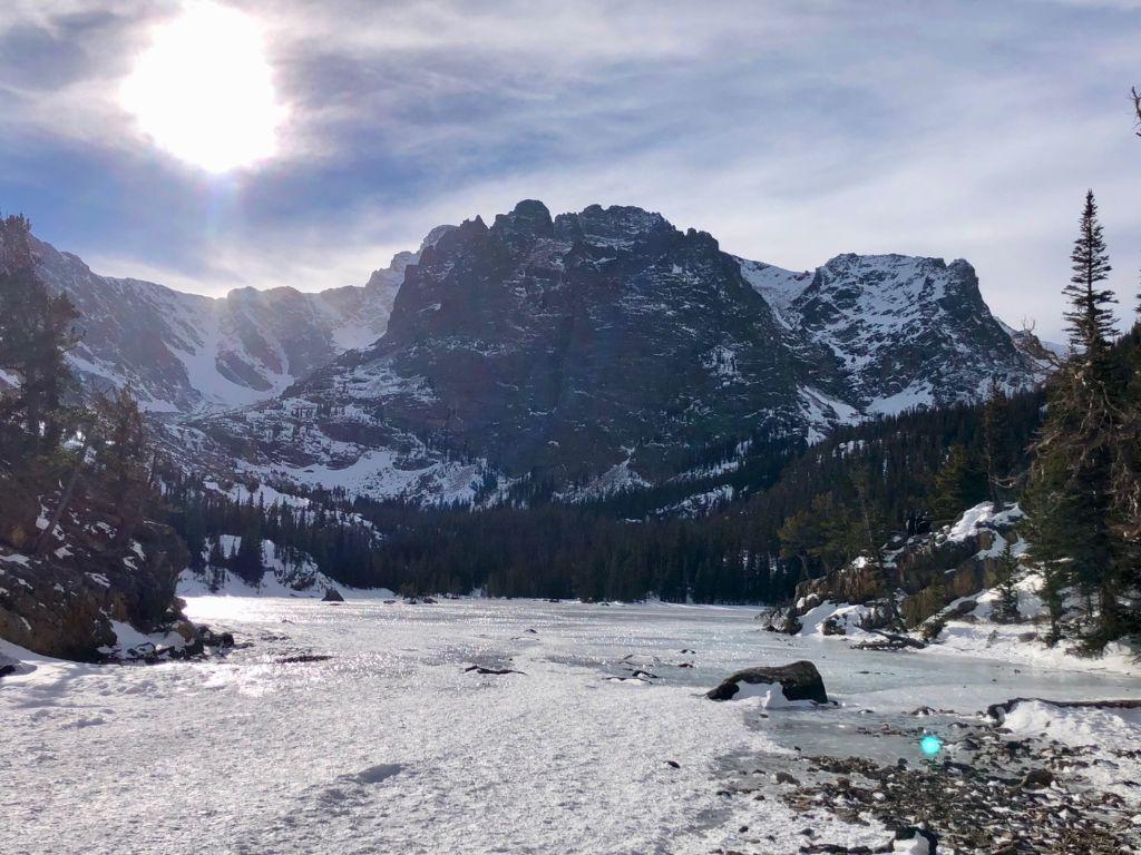
Upon reaching The Loch, the first thing I noticed was a shift in the weather. Winds started to pick up and would keep things cold and loud from there on out. The second thing to note was that the trail almost immediately disappeared.
Utilizing a downloaded map on my phone’s AllTrails app (that I had also carried on paper, thankfully) and the GPS mapping on my Garmin inReach, I felt comfortable pushing onward to break through old snow. I found that keeping track of a known landmark – a frozen creek that followed a portion of the trail – also helped with navigation.
Surrounded by a wall of mountains and howling wind, I quickly gained elevation as I left The Loch behind.
While no tracks existed – either due to drifting snow or lack of people on the trail in recent days – the map and my prior knowledge of the route allowed for effective navigation amid the uphill terrain. Though snowshoes had not been needed prior to this, a pair could have been nice – unfortunately I was ignorant and left them in my trunk.
With careful steps, I reached the base of Timberline Falls. This is a frozen waterfall that must be scaled to reach the basin that holds Lake of Glass and Sky Pond. Climbing it was possible without having to touch much ice on the date that I was there – as I avoided the frozen bits, it was most comparable to class three scrambling. Still, a few snow-covered holds made my boot crampons necessary and my axe a tool that I was thankful to have brought along.
At the top of the falls, the view opened up to the Lake of Glass and was accompanied by another blast of wind. Had the wind not been present, the rest of the hike would have been a very different experience, but the wind was persistent – much stronger than what had been forecasted for the area, too. It was an important reminder to always be prepared for conditions worse than anticipated, especially in the winter.
This is where the winter trail got a bit more abstract.
On terrain made up of rocks aside pockets of deep snow, safe route-finding became much more involved. Familiar with the standard approach and comfortable with high-elevation scrambling, I opted to stay high, where more rock was showing, making my way in the direction of Sky Pond. Slowly, but surely, progress was made, albeit my breaths grew heavy.
After a bit of scrambling that took a little longer than expected and involved a few slips into hidden waist-deep powder pockets, the route dropped into the portion of the 10,900-foot basin where Sky Pond is located.
Desolate. Frigid. Breathtaking.
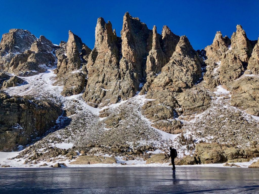
I had arrived at, perhaps, the most beautiful place in Colorado. Jagged rock walls towered above me. A dry blast of snow whisked across the opaque ice covering the pond, skipping across weathered cracks and small bubbles of air frozen in place just beneath the surface.
I stepped onto the ice, my crampons crunching as they left their mark. From the center of the alpine lake, the full view of my surroundings could be appreciated.
The most prominent view at Sky Pond is of the iconic Cathedral Spires, which includes the Sharkstooth formation. This formation demands attention in photos of the spot and I found it even more awe-inducing in real life. Taylor Peak also stands tall above the pond, hitting an elevation of 13,158 feet at the summit – more than 2,000 feet above Sky Pond at 10,900 feet above sea-level.
After staying at Sky Pond until the blasting wind made it almost unbearable, I made the return trip – this time, much easier, traveling the route in the opposite direction and with better lighting. In about half the time it took to reach my turnaround point, I was in the car and headed home.
Overall, my trip to Sky Pond was an unforgettable experience, as many in Colorado’s Great Outdoors tend to be. While I expected the trail to be more difficult to follow during the winter, I didn’t expect to be breaking trail many days after the last snowfall. This added a layer of navigation and physicality that could have been a deterrent if I wasn’t prepared.
Surely among Colorado’s most stunning scenes, Sky Pond is a spot admired by many, but seen in-person by few – especially during winter months. If you plan to visit this destination, proceed with extreme caution, make decisions that prioritize safety, and, as always, leave no trace.
Editor’s Note: Ice safety is something that should be taken very seriously. Know how to judge if ice will be able to hold you and know what to do if it doesn’t. Don’t assume that because ice holds someone else, that it will also be safe for you. Accidents can always happen and they can be deadly. Proceed with extreme caution and only if you are experienced in traveling over ice. Read more about ice safety here.
Get OutThere
Signup today for free and be the first to get notified on new updates.
PREV
PREVIOUS
Up to 18" of snow could hit Colorado mountain range this weekend amid widespread snow
It’s going to be a weekend of snow around Colorado’s high country – it won’t be much snow in most places, but there should be some fresh powder at some of the state’s resorts – particularly those in the southwest. Along with the snow will likely come concerns related to high-country travel amid slick conditions, […]

19 Denver metro area restaurants open for Thanksgiving in Colorado
As Thanksgiving approaches, Coloradans are planning their meals for the big day, with turkey, mashed potatoes, gravy, and much more. However, for those who don’t feel like cooking there are plenty of Colorado restaurants open on Thanksgiving. Here are some Denver restaurants staying open for Thanksgiving: Located near Ball Arena and Union Station, this upscale, […]