


12-plus inches of additional snow could hit Colorado if ‘high-end’ forecast pans out
After a snowy weekend in Colorado, it’s looking like a bit more fresh powder could be on the way. That said, predictions related to potential accumulation totals vary greatly depending on what scenario shakes out.
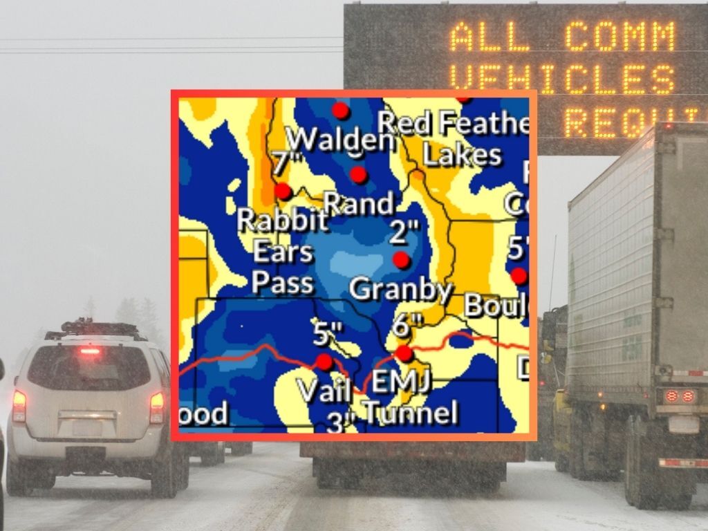
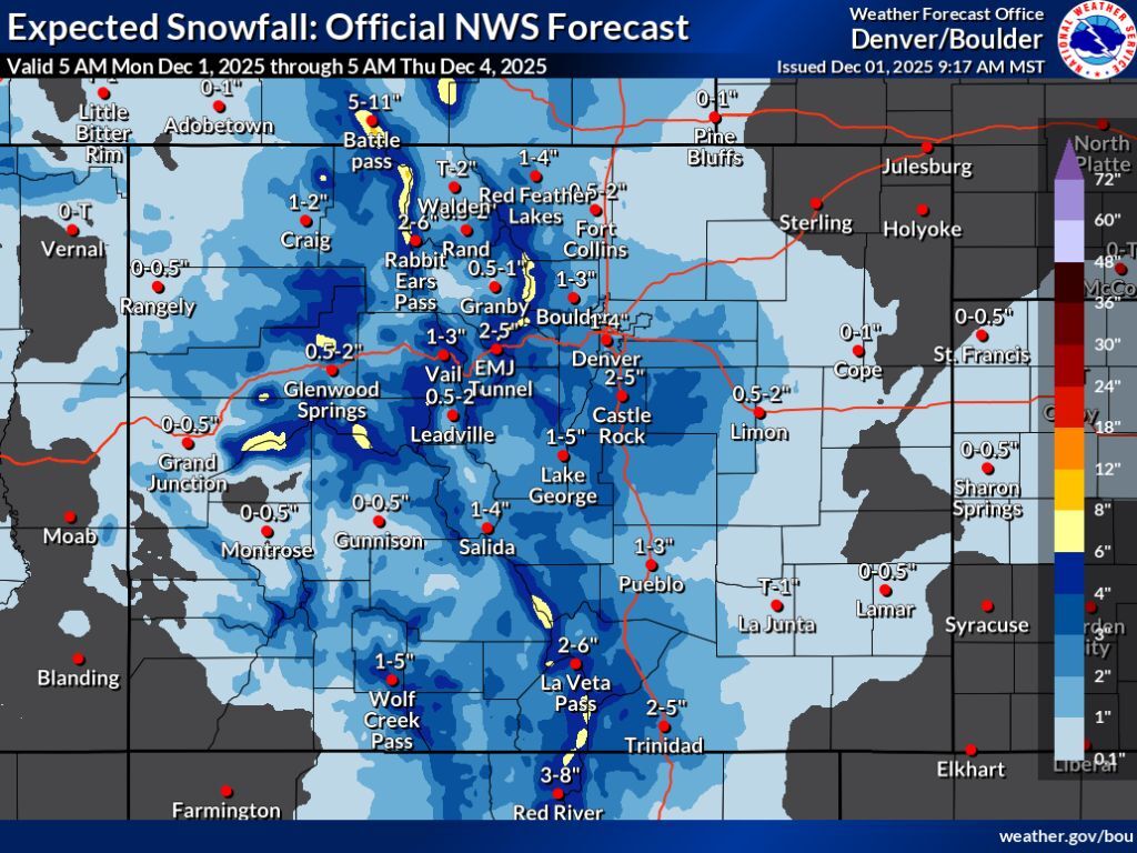
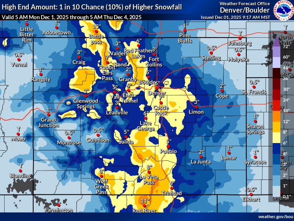
The National Weather Service publishes three snowfall prediction maps – low-end (10% chance), ‘expected’ (80% chance) and high-end (10% chance). While the ‘low-end’ map shows the chance for about one to three additional inches of widespread snow through Thursday morning, the ‘high-end’ snowfall forecast map shows the possibility for much deeper accumulation – a foot or more on many peaks.
Let’s dig into the ‘expected’ snowfall forecast map first, as this has the highest chance of coming to fruition at an 80% chance.
In this scenario, widespread snow occurs during the week, but totals top out at less than six inches on most peaks, with about one to four inches possible in the Denver area. This could still cause travel concerns, as parts of I-70 could get hit with a few inches of snow, as well as many other roads around Colorado’s mountainous terrain.
The ‘high-end’ snowfall scenario depicts a much more impactful snow event, upping snowfall possibilities in Denver to six inches, with snowfall in the range of eight to 12 inches possible on the stretch of I-25 between the Mile High City and Colorado Springs. Meanwhile, many peaks in northern and southern Colorado could get snow in the range of eight to 12 inches, with 12 to 18 inches of snow possible in some select high elevation areas.
Find a look at both of those maps below starting with the ‘expected’ scenario. Keep scrolling to find ‘high-end’ predictions:
As far as Colorado’s ski resorts go, OpenSnow predicts that Beaver Creek and Steamboat Springs get the most snow over the next five days – about nine inches. See the full resort-by-resort five-day forecast from OpenSnow here.
This past weekend’s storm helped Colorado’s snowpack in a big way, with the state’s snowpack now at about 46 percent of the norm for December 1. This compares to the state being at about 36 percent of the norm for the date headed into the holiday weekend.
Find additional weather forecasting from the National Weather Service here.
STAY INFORMED: Get free Colorado news with our daily newsletter (Click here)
Get OutThere
Signup today for free and be the first to get notified on new updates.
PREV
PREVIOUS
I-70 reopens after closures near Glenwood Springs
Interstate 70 has been reopened after multiple crashes involving multiple vehicles caused the road to close near Glenwood Springs. The first crash occurred in the westbound lanes near mile point 118, east of Glenwood Springs. I-70’s westbound lanes were closed right before noon from Dotsero to Glenwood Springs. The westbound lanes were opened around 1:20 […]

Red Rocks event list for 2026 climbs to 53 performances as December hits
Curious what events are set to take place at a venue that many consider to be Colorado’s ‘most iconic’ in 2026? In our latest update, we highlight 4 recently announced shows (and a pre-show yoga session) that are now on the calendar for 2026, bringing the running total to 53 concerts and comedic performances already […]