


Colorado’s snowpack at just over half of norm for date – even less in some regions

As the end of the year nears, Colorado’s snowpack is still way behind the norm for the date. And while there’s a little bit of snow on the way over upcoming days, OpenSnow’s Joel Gratz has reported that the “trend in the forecast is not a positive one, with less snow likely compared to previous forecasts.”
Just how far is Colorado’s snowpack behind compared to the norm? Right now it’s at 55 percent of what’s typical for December 23 statewide, according to the USDA.
Here’s a look at how each region stacks up:
Arkansas River Basin (southern Colorado): 52 percent of norm
Colorado Headwaters River Basin (western Colorado, north of Grand Junction): 50 percent of norm
Gunnison River Basin (western Colorado, south of Grand Junction): 52 percent of norm
Laramie and North Platte River Basin (northern Colorado): 69 percent of norm
San Miguel-Dolores-Animas-San Juan River Basin (southwest corner of state): 47 percent of norm
South Platte River Basin (northern Front Range): 63 percent of norm
Statewide: 55 percent of norm
Upper Rio Grande River Basin (southern Colorado): 52 percent of norm
Yampa-White-Little snake River Basin (northwest Colorado): 63 percent of norm
Meanwhile, dry conditions continue to linger in Colorado, with roughly 57 percent of the state abnormally dry or worse, with about 36 percent of the state in technical drought. Drought is most severe in the state’s northwest quadrant.
Over the next five days, OpenSnow reports that Steamboat and Wolf Creek should get about 11 inches of fresh powder, with other resorts in the single digits. Find the full OpenSnow report here.
STAY INFORMED: Get free Colorado news with our daily newsletter (Click here)
Get OutThere
Signup today for free and be the first to get notified on new updates.
PREV
PREVIOUS

4.6-star spot dubbed Colorado's 'best Italian restaurant' known for handmade noodles
The winter season is the perfect time for a hearty Italian meal, savory and filling and sure to lead to a cozy tail-end of the night. While pasta is perhaps one of the most popular at-home dishes, sometimes tracking down fresh handmade noodles created by a professional is what the soul craves. A recent piece […]
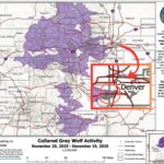
Updated wolf map shows species in Denver County watershed
Colorado Parks and Wildlife has released their monthly wolf tracking map, which shows the watersheds where the species has been detected from November 25 through December 19, 2025. Notably, the map shows that wolves have been present in a watershed area that includes a small portion of Denver County – while this watershed is a […]