


‘Winter Storm Warning’ activated with double-digit totals possible on I-25
Thursday and Friday are set to bring snow to a large portion of Colorado, and if the ‘high-end’ snowfall forecast from the National Weather Service holds true (10% chance), major travel impacts could occur along both I-25 and I-70.
In the state’s more populated Front Range, snow is expected to ramp up during late-afternoon hours on Thursday, continuing into the evening and overnight, tapering off as Friday progresses. As far as the I-25 corridor goes, the most snow is expected south of Denver. The National Weather Service has noted that Thursday evening and Friday morning commutes could be difficult, especially in the Pikes Peak region.
Maps of both the ‘expected’ snowfall scenario (80% chance) and the ‘high-end’ snowfall scenario (10% chance) through Sunday morning can be found in the article below, and remember, most of this snow will be falling on Thursday and Friday with Saturday and Sunday expected to be mostly dry. Before digging into that, though, here are a few key takeaways to consider.
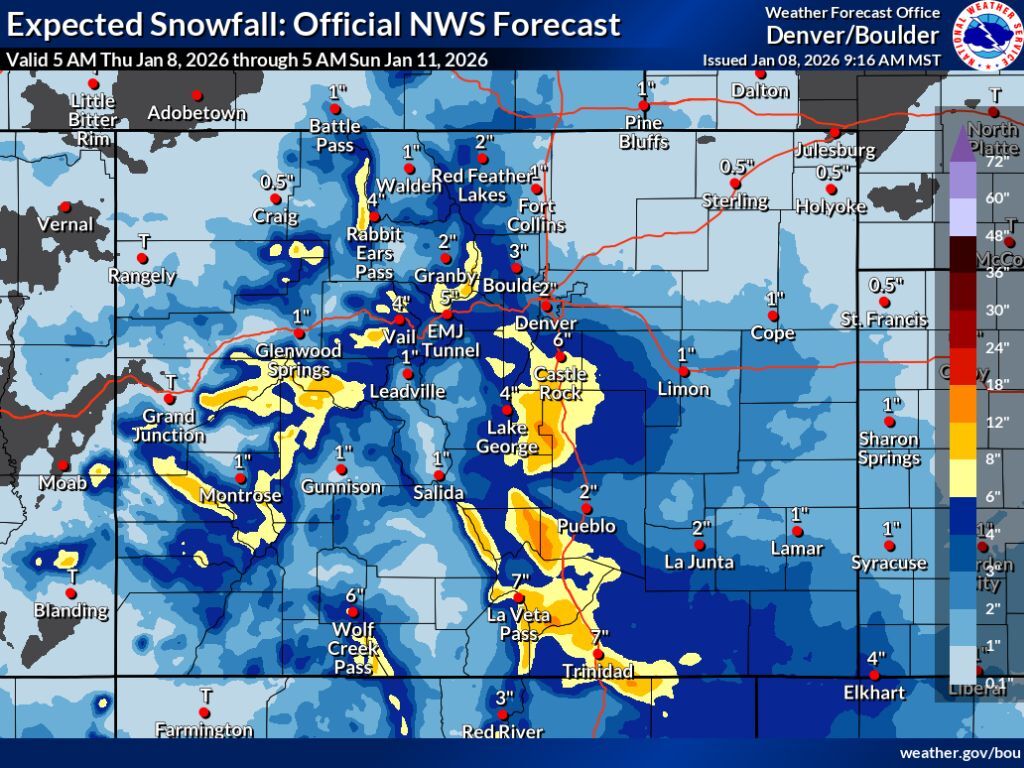
Expected scenario:
- Denver only gets 2 inches in this scenario while Colorado Springs gets between six and eight.
- Between six and 12 inches of snow fall between Castle Rock and Colorado Springs
- The I-70 corridor gets between four to six inches
- Impacts would likely be relatively limited compared to the ‘high-end’ scenario
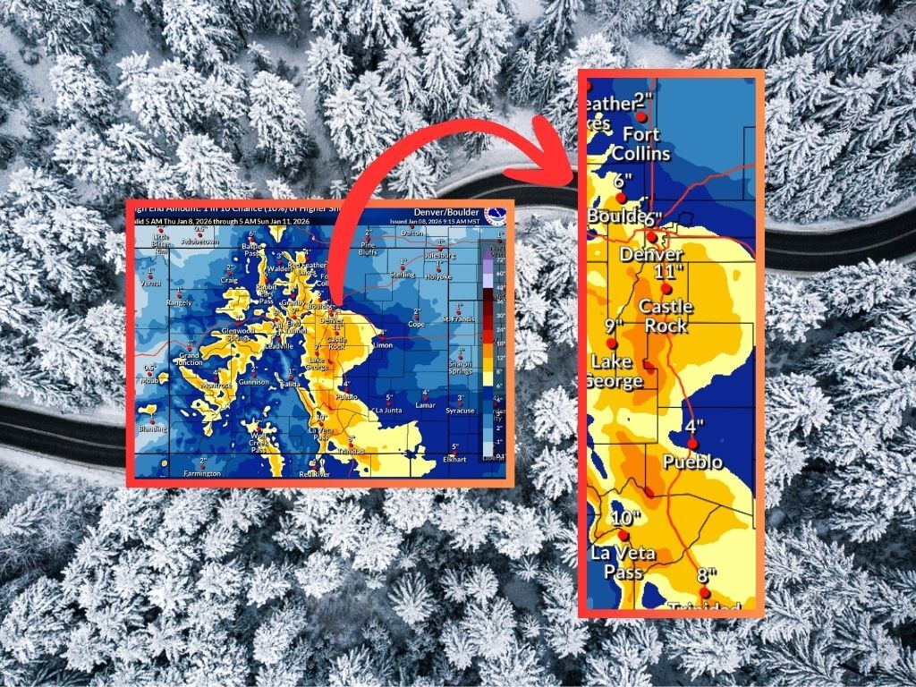
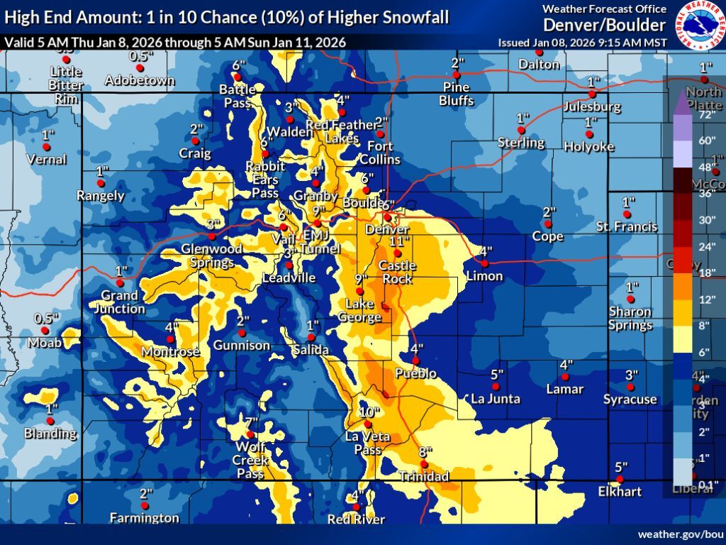
High-end scenario:
- Denver gets up to six inches of snow, Castle Rock gets 11, and Colorado Springs gets between eight and 12.
- Pikes Peak gets snow in the range of 18 to 24 inches
- The stretch of I-25 between Pueblo and Trinidad gets between eight and 12 inches
- Parts of the I-70 corridor get between eight and 12 inches with nine expected around the Eisenhower-Johnson tunnel complex.
- This scenario would bring widespread impacts for many Coloradans, likely resulting in travel delays in the Denver metro area, along I-25, and along I-70.
Without further ado, here’s a look at both maps:
Note: While these maps show the various snowfall forecasts from Thursday morning through Sunday morning, Saturday and Sunday shouldn’t bring much snow, if any. Expect the majority of the depicted totals to come Thursday and during the first half of Friday in most areas.
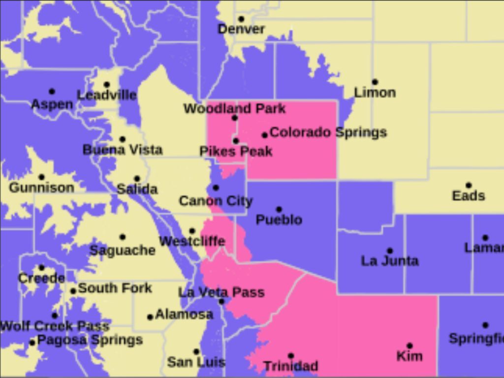
Given the snow that’s on the way, a ‘Winter Storm Warning’ has been activated for the Pikes Peak region and parts of southern Colorado, with widespread ‘Winter Weather Advisories’ active, too (additional details here).
It should also be noted that this storm is favoring the Front Range and I-25 corridor over the state’s ski resorts. OpenSnow calls for Snowmass to get the most powder of the next five days at nine inches.
As of January 8, Colorado’s statewide snowpack is at about 63 percent of the norm for the date – still lower than where it was at this point in the season than all but two years since 1987 (2000 and 2018). That said, widespread snow of this nature could be a nice boost if the high-end snowfall forecast ends up coming to fruition.
Find additional forecasting from the National Weather Service here.
STAY INFORMED: Get free Colorado news with our daily newsletter (Click here)
Get OutThere
Signup today for free and be the first to get notified on new updates.
PREV
PREVIOUS

Breckenridge man arrested after messages "detailed plans and a timeline" for local mass shooting
According to the Summit County Sheriff’s Office, a man was arrested on January 7 for allegedly threatening to commit a mass shooting in the local area. Law enforcement responded to the suspect’s residence in unincorporated Breckenridge on Wednesday after receiving multiple reports related to the male threatening to kill himself and other people. Deputies arrived […]

Climber was left stranded on 4x4 ledge after partner fell 500 feet to death in Colorado
Additional details have been released related to a New Year’s Eve mountain climbing accident that occurred in Colorado resulting in the death of 52-year-old Shafiq Noorani of Aurora. According to a January 7 update from the Alpine Rescue Team, Noorani fell more than 500 feet from the northeast face of The Citadel on December 31, […]