


Colorado ski area could get 20″ of snow this week as widespread winter storm hits
In a storm forecast that comes with “high uncertainty” according to OpenSnow’s Joel Gratz, significant snow may finally be hitting Colorado’s mountains between Thursday night and Saturday of this week.
Colorado’s statewide snowpack is currently at about 57 percent of the norm for January 21 – the record-low for the date since at least 1987, when snowpack records started. At this point, Coloradans are desperate for any mountain snow, and it’s looking like Centennial Staters will finally get their wish.
Expected totals vary quite a bit depending on what scenario ultimately unfolds, though its looking like most of the state will see at least some snow through the start of the weekend.
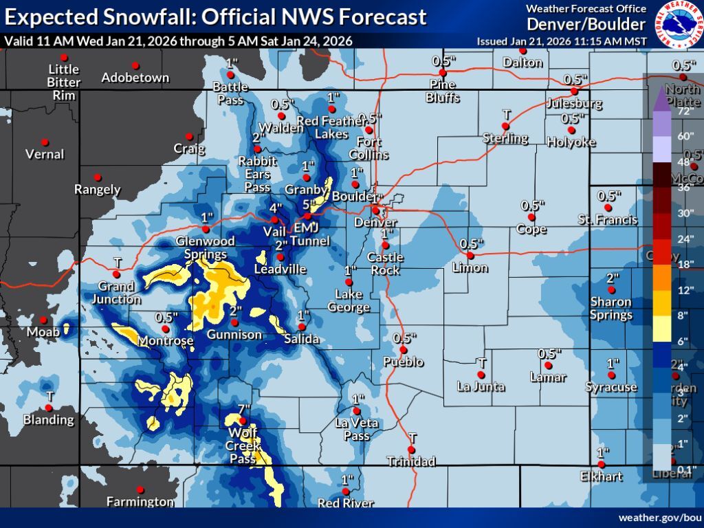
As noted in past reporting, the National Weather Service publishes forecasts related to a few different scenarios ahead of each storm – the ‘expected snowfall’ (80% chance), the ‘high-end snowfall’ (10% chance), and the ‘low-end snowfall’ (10% chance).
Starting with the most likely scenario – the ‘expected’ snowfall scenario – peak totals land in the range of eight to 12 inches in mountains near Aspen, those near Telluride, and around Wolf Creek Pass. Elsewhere, totals of about two to six inches can be expected on most peaks through Saturday morning, with a few exceptions in the range of six to eight inches.
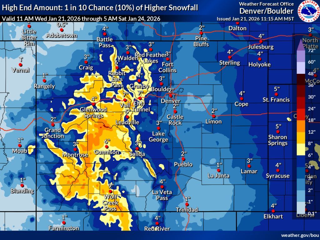
Meanwhile, the ‘high-end’ snowfall scenario shows that totals in the range of eight to 12 inches could be much more widespread, spanning all nearly all of Colorado’s central and western peaks. In areas hit the hardest in the aforementioned ‘expected’ scenario, totals could hit 12 to 18 inches through Saturday morning, or even a bit higher in some very limited areas.
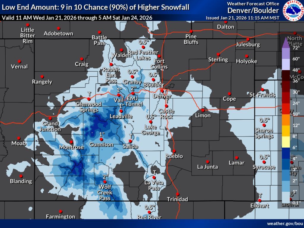
And then, of course, there’s the ‘low-end’ snowfall scenario, which depicts a situation where this storm fizzles out. This would mean that peak totals end up being two and six inches on western peaks south of I-70, with not much snow elsewhere.
Regardless of the scenario, impacts along the state’s heavily-populated I-25 corridor should be fairly limited, with only a couple inches of snow possible even in the high-end scenario.
The OpenSnow resort-by-resort five-day forecast seems to echo the possibility of the ‘high-end’ scenario taking place, though this report also includes potential snowfall throughout the day on Saturday, as well, opposed to National Weather Service mapping which is currently available only through Saturday morning. In this OpenSnow report, Wolf Creek gets hit with 20 inches of snow over the next five days and Monarch gets 18. Other resorts get between seven and 13 inches (see the full breakdown here).
It’s also worth noting that several sources call for more moderate totals. Open-Metro is calling for a maximum of about six inches at resorts in the Durango area over the next five days, while Pivotal Weather is showing peak totals of about nine inches in the area of Aspen through Monday morning.
Given the significant variance between forecasts, it looks like a lot of the potential for this storm remains up-in-the-air. Either way, at least some snow should be hitting Colorado.
Find additional weather reporting from the National Weather Service here.
STAY INFORMED: Get free Colorado news with our daily newsletter (Click here)
Get OutThere
Signup today for free and be the first to get notified on new updates.
PREV
PREVIOUS

More wolves coming to Colorado? CPW provides update on potential 2026 release
Those following along with Colorado’s wolf reintroduction effort have likely been wondering if – and when and where – wolves would be released into the state’s landscape during the winter of 2025 to 2026. After all, wolves were translocated and released during the 2023-2024 winter and the 2024-2025 winter. With the end of January approaching, […]
A skier's guide to Eldora Mountain: Terrain, dining, lodging, parking, and more
Often referred to as Boulder’s “backyard” mountain, Eldora Mountain ski area offers skiers the perfect spot for a quick, convenient, and high-quality ski day without the hassle of I-70 traffic. Eldora is regarded as a top resort for beginners and kids, with great lessons and easy terrain, though it also offers glades and steeps for […]