


Forecast intensifies to show 24″ of snow possible on some Colorado peaks thru weekend
Good news or bad news first? I’ll start with the bad news.
Colorado’s snowpack currently sits at just 56 percent of the norm for the date at the statewide level – the lowest for January 22 since records started in 1987. It’s also looking like above-norm temperatures could continue for much of the state as the snowier months of the year start to hit.
Now for the good news – snow forecasts for this upcoming weekend have ramped up, showing deeper totals and providing a glimpse at the start of a potential turnaround in the season that could hit mid-February.
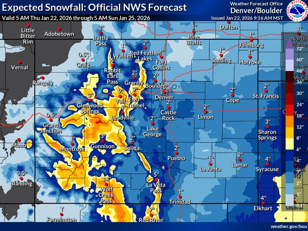
As has been noted in OutThere Colorado snowfall reports many times before, the National Weather Service provides multiple maps based on various snowfall scenarios that could occur – the ‘expected’ scenario with an 80 percent chance, the ‘high-end’ scenario with a 10 percent chance, and the ‘low-end’ scenario, also with a 10 percent chance. The latest maps published by this agency account for Thursday morning through Sunday morning, with significant snow expected and double-digit accumulation totals possible in at least somewhere in the state in all scenarios.
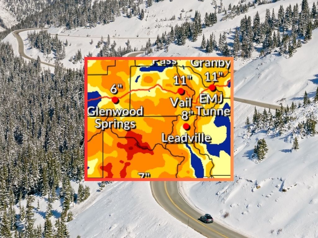
Across the board, the central mountains and southern mountains get hit the hardest through Sunday morning.
In the ‘expected’ and most likely scenario, peak totals hit about 18 to 24 inches near Aspen and just south of Wolf Creek Pass, with totals in the range of eight to 18 inches expected on many peaks around the western half of the state.
See this ‘expected’ scenario depicted on the map below and keep scrolling for a look at other scenarios:
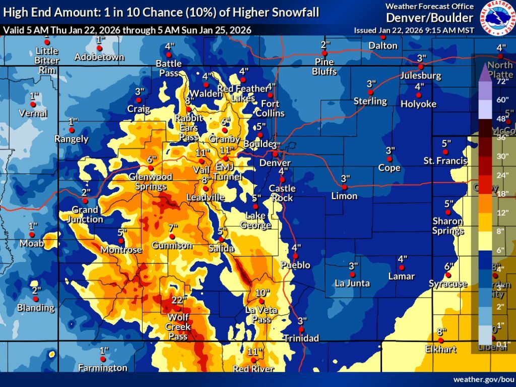
Next, let’s take a look at the ‘high-end’ snowfall forecast – this shows similar areas getting hit the hardest, but that totals in the range of 12 to 18 inches could be much more widespread, with more peaks having a shot at snow in the range of 18 to 24 inches, too – and some in the Elks and Sangre de Cristos having potential for 24 to 30. This scenario also shows a significant uptick in snowfall for peaks north of I-70. More snow would also be possible on the Eastern Plains – about four to eight inches, which has many times proven to be enough when it comes to impacting travel in this region.
See the ‘high-end’ scenario depicted on the map below:
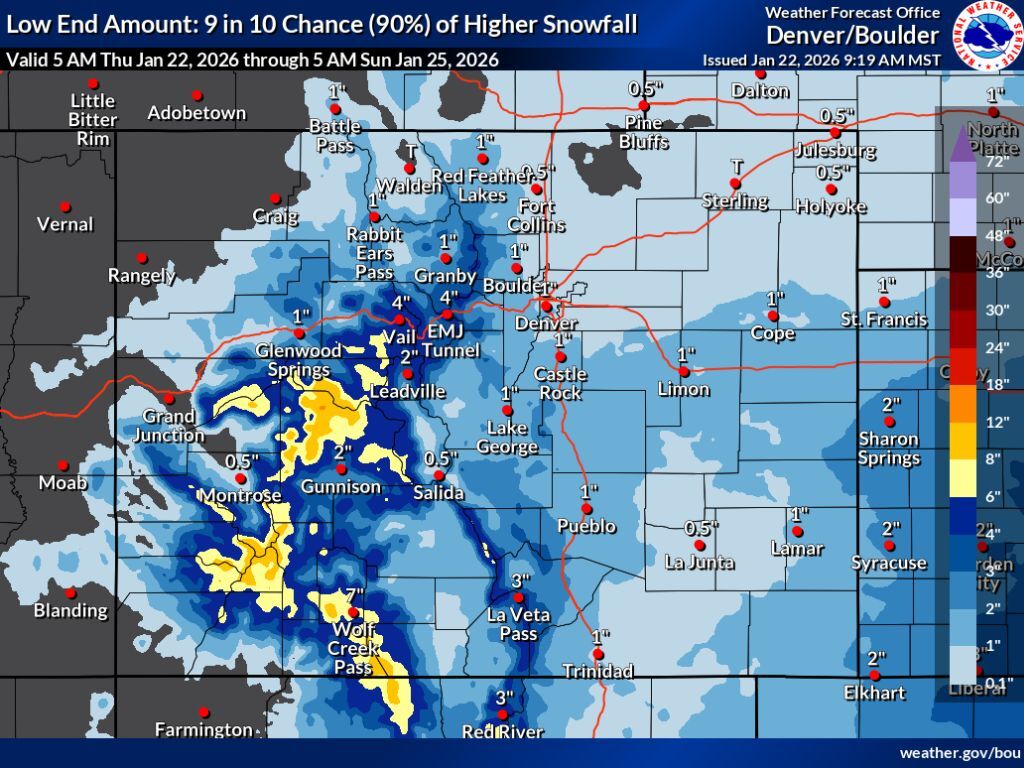
The third scenario that’s published – the ‘low-end’ scenario – again shows similar areas getting hit the hardest, and even in this scenario, localized areas in the peaks near Aspen could get snow in the range of 12 to 18 inches. Meanwhile, most western Colorado mountains south of I-70 see between four and 12 inches with less snow elsewhere.
See this ‘low-end’ scenario depicted on the map below:
In all scenarios, at least some snow hits Colorado from Thursday into Sunday morning. Totals along the Front Range metro areas should be manageable – about an inch in Denver on the low-end up to four inches on the high-end. I-70 travel into the mountains, however, could see greater impacts, with the high-end scenario showing between 12 to 18 inches being possible on some stretches of this heavily-trafficked route. Couple that with increased traffic of desperate Coloradans long awaiting a powder day and that’s the recipe for delays.
For slopesport enthusiasts on the hunt for fresh snow, the risk of a long, delay-ridden drive into the mountains might be worth it. According to OpenSnow, Wolf Creek, Monarch, Snowmass, Silverton, and Telluride can all expect more than a foot of accumulation over the next five days. Find the full resort-by-resort breakdown here.
Could all of this snow be enough to push Colorado above all-time snowpack lows? Maybe there’s a chance if the high-end totals end up hitting. The state currently sits at a 4.8 inches of snow-water equivalent and the all-time low by Sunday is 5.5 inches. Either way, there’s a good chance snowpack will slip back below the all-time low of 6.0 inches by January 31.
Find additional forecasting information from the National Weather Service here.
STAY INFORMED: Get free Colorado news with our daily newsletter (Click here)
Get OutThere
Signup today for free and be the first to get notified on new updates.
PREV
PREVIOUS

Two dogs sustain life-threatening injuries from coyote attacks in Denver metro
Pet owners in the Denver-metro city of Lafayette have been urged to exercise caution after two small dogs were attacked by coyotes over the last two days. According to the local police department, the dogs sustained life-threatening injuries. One encounter took place in a yard on Shoshone Trail and the other in a yard on […]

Often-overlooked 'Little Rocky Mountain National Park' a 70,000-acre hidden gem known for moose
Sometimes referred to as ‘Little Rocky Mountain National Park,’ Colorado’s largest state park spans 70,932 acres. This means that while it’s just over a quarter of the size of its nickname’s namesake (265,807 acres), it’s larger than both Mesa Verde National Park (52,485 acres) and Black Canyon of the Gunnison National Park (30,750 acres). Even […]