


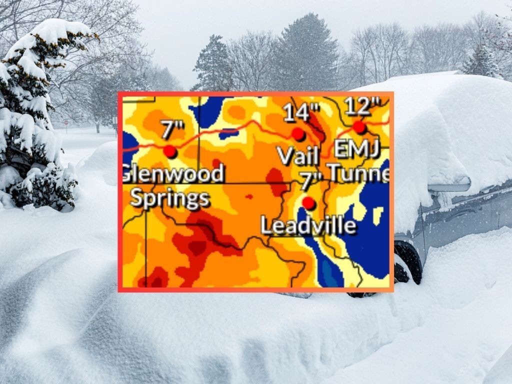
27″ of snow possible along highway stretch that travels thru Colorado mountains
A winter storm is upon Colorado, with temperatures expected to plunge to the single-digits and even far below zero in some parts of the state. Along with the frigid temps will come plenty of snow – about eight to 18 inches on many western Colorado peaks found south of I-70 even if the storm ‘fizzles out’ and the ‘low-end’ snowfall expectation holds true.
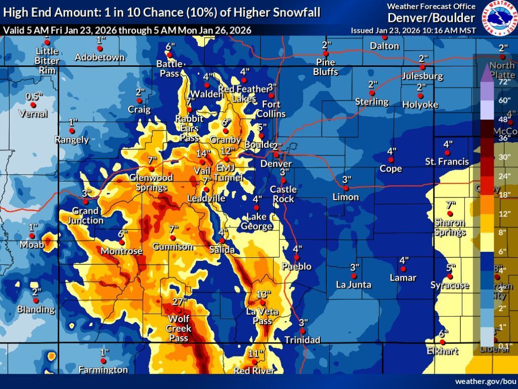
The ‘low-end’ snowfall totals probably won’t become reality though, given the 10 percent chance for this scenario. More likely, is the ‘expected’ snowfall scenario – with an 80 percent chance – and then there’s also the ‘high-end’ snowfall scenario, with a 10 percent chance and a scenario that would be likely to result in major travel disruptions if it comes to fruition.
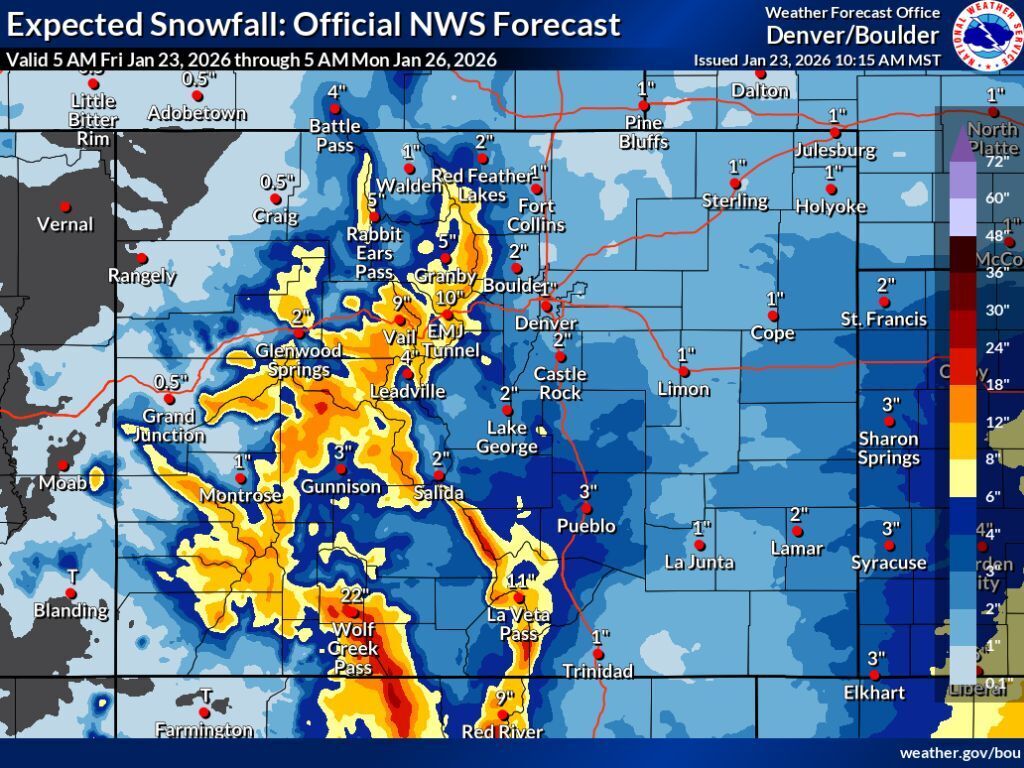
Let’s start with the ‘expected’ snowfall scenario – in this situation, the majority of Colorado’s mountains get between eight to 18 inches of snow through Monday morning, with totals in the range of 12 to 18 inches being widespread in the western half of the state. Some peaks could get even more, with the Elk Range near Aspen and mountains south of Wolf Creek Pass having a chance of 18 to 24 inches, along with some peaks in the Sangre de Cristo range. While this forecast stretches into early next week, the majority of this snow is expected on Friday and Saturday (map of this scenario found below in article).
Next, let’s get into the ‘high-end’ scenario – less likely, but a scenario that would undoubtedly result in travel delays amid frigid temperatures. In this scenario, more peaks get snow in the range of 18 to 24 inches through Monday morning, with some expected to get snow in the range of 24 to 30 – specifically the Elks near Aspen, the Sangre de Cristos, and those near Wolf Creek Pass. Parts of I-70 get snow in the range of 12 to 14 inches with Wolf Creek Pass getting a whopping 27 inches of snow. As Coloradans know, it doesn’t take much for vehicles to start sliding and lanes to get shut down, thus in this scenario – or the aforementioned ‘expected’ snowfall scenario – it will be crucial to be prepared for serious travel concerns.
In all scenarios, the Front Range metro area is expected to be mostly missed, with about two inches of snow expected in Denver should the ‘high-end’ snowfall scenario occur. That’s not to say the Front Range won’t be impacted by this winter storm, though. Denver, for example, is expected to hit a temperature of negative five degrees over the weekend, and that’s significantly warmer than what’s expected in some other spots. Breckenridge could hit -16 in the mountains and Limon on the Eastern Plains could hit -21.
See mapping of both the ‘expected’ and the ‘high-end’ snowfall scenarios below:
It’s likely there will be quite a bit of traffic on the roads this weekend despite the weather given that many Coloradans are desperate for a powder day on the slopes. This will make it crucial to pack the trunk with this weather in mind, knowing that getting stuck or stranded is a possibility. Don’t leave for the mountains without a full tank of gas and considering bringing along these 27 survival items for the drive.
As of January 23, Colorado’s snowpack is at just 56 percent of the norm for the date – an all-time low since records started in 1987. Perhaps this storm could, however, play a major role in turning the season around.
Find additional forecasting information on the National Weather Service website.
STAY INFORMED: Get free Colorado news with our daily newsletter (Click here)
Get OutThere
Signup today for free and be the first to get notified on new updates.
PREV
PREVIOUS

Winter struggles prompt town to announce popular ice rink won't open this year in Colorado
The unusually warm winter (and lack of snow) is having a pretty significant impact on winter outdoor recreation in Colorado. From lack of open terrain at the state’s resorts to Rocky Mountain National Park’s only sledding slope still being mostly barren, the weather has meant changing plans for many people, locals and tourists, alike. One […]

CBI concludes review of investigation into Hunter S. Thompson's death
The Colorado Bureau of Investigation has announced that a follow-up investigation into the death of Hunter S. Thompson that came at the request of Thompson’s widow has confirmed that Thompson died of suicide. The formal request for the review was received by the Pitkin County Sheriff’s Office on July 31, more than 20 years after […]