


Colorado spot reports 23″ of snow over weekend, but when will more snow hit?
Colorado got some pretty decent snow totals over recent days – not enough to turn the season around quite yet, but more snow might be on the way soon.
Before digging into snow that might be on the way, here’s a list of a few snow totals from the last few days:
Note from the author: These snow totals come from the National Weather Service showing totals over the last 72 hours unless an outbound link citing another source is present.
- Crested Butte: 23 inches (note: NWS cited a weather station located in mountains west of town, the local ski resort reports much less)
- Sawpit: 18.5 inches
- Monarch Pass: 14 inches (resort got less – four inches in last 48 hours; 15 inches in last seven days)
- Vail Resort: 6 inches in last 48 hours; 14 inches in last seven days
- Aspen Snowmass: 13 inches in last 72 hours
- Breckenridge Resort: 4 inches in last 48 hours; 13 in last seven days
- Wolf Creek Pass: 12 inches
- Telluride Resort: 3 inches in last 48 hours; 11 in last seven days
- Steamboat Resort: 10 inches in last three days
- La Veta Pass: 6 inches
- Crestone: 5.6 inches
- Durango: 5.3 inches
- Colorado Springs: 5.1 inches
- Wetmore 5 inches
- Denver: 1 to 3 inches
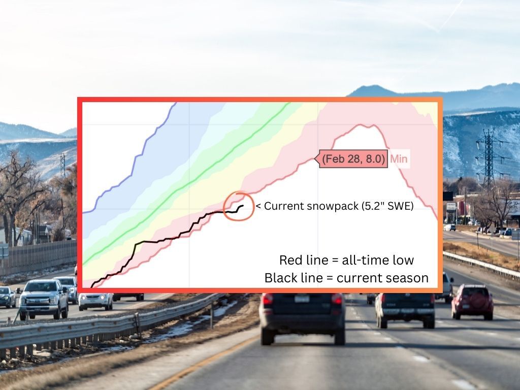
In other words, some snow landed this weekend. That said, it ended up best reflecting the lower-end of the estimated snowfall scenario from the National Weather Service – not the 10 percent chance ‘high-end’ scenario that would have meant deeper totals being more widespread. Unfortunately, this snow wasn’t quite enough to pull Colorado’s statewide snowpack back above all-time record lows. The state’s snowpack currently sits at 58 percent of the norm for the date with a to-date snow-water equivalent of 5.2 inches compared to the previous all-time low of 5.6.
Now, let’s look ahead. Unfortunately, the National Weather Service continues to show no real chance of widespread precipitation in Colorado through at least February 2, with the state also absent from warnings on the agency’s ‘risk of heavy snowfall map’ that extends through February 8. Meanwhile, OpenSnow notes that no major storms will occur for the next two weeks with a turnaround possible on February 10. The skiing-focused forecasting service does, however, call for a refresh of about seven inches at Steamboat Resort over the next five days (three inches or less expected elsewhere).
Looking ahead to that February 10 date noted by OpenSnow, AccuWeather is calling for just five days of snow in Breckenridge between then and February 24, none of which look too noteworthy. Steamboat might get more snow during that period though, with seven days of snow expected between February 10 and February 24 and more snow expected on most of those days. That said, it’s still not looking like much.
The big question is whether or not the typically snowy month of February could be enough to bring this season back above all-time lows in terms of snowpack for the state of Colorado. At this time and given the forecasts that are available, it’s looking like that won’t be the case. As was previously noted, the snowpack currently sits at 5.2 inches of snow water equivalent. By February 10 – which looks like it will bring the next real chance of any regular widespread snow – the snowpack will need to be at 6.7 inches to reach the current all-time low. By the end of February, it will need to reach eight inches. At this time, the forecast is making that seem impossible.
By all accounts, it’s looking like Colorado’s record-low snowpack season is set to continue.
STAY INFORMED: Get free Colorado news with our daily newsletter (Click here)
Get OutThere
Signup today for free and be the first to get notified on new updates.
PREV
PREVIOUS

A skier's guide to Vail Ski Resort: Terrain, dining, lodging, parking, and more
Renowned for its vast terrain, Vail is the largest single-mountain ski resort in North America. With over 5,300 acres of skiable terrain, including the extensive back bowls (known for their deep powder and tree glades), Vail Ski Resort offers a world-class skiing experience. As well as the incredible skiing, Vail is known for its European-style […]
Monarch Mountain's long-dreamed No Name Basin set to debut
The trails have been cut. The chairlift is ready. And finally, the snow came. It’s time for perhaps the most anticipated terrain expansion in Monarch Mountain’s 87 years. An opening celebration is set for No Name Basin on Thursday — what the ski area described as “a historic milestone” in its announcement. That morning, the […]