




12″ of snow could hit Denver over upcoming 24-hour stretch
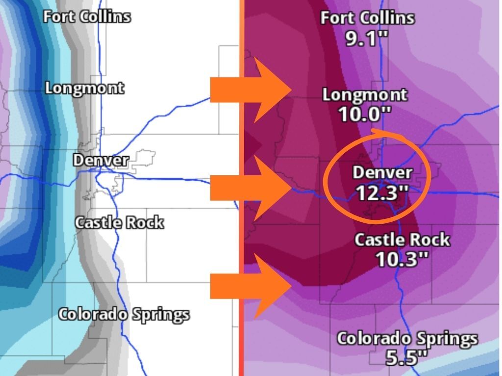
Much of the Front Range has escaped serious snow thus far this winter, but that could change come the first week of March. Current forecast mapping from Pivotal Weather shows that Denver is favored to be one of the snowiest places in the state over upcoming days, specifically during a 24-hour stretch that will make all of the difference.
UPDATE (2/26/26): Given that this Pivotal Weather forecast is looking more than a week ahead, expect a lot of change over coming days. The latest mapping shifts this forecast to a stretch between March 6 and March 8, dropping expected totals to 10 inches during that time. That said, the forecast now calls for 14 inches through the end of March 12 – in other words, more snow but over a longer period of time. It’s also worth noting that while Pivotal Weather is a source that’s proven fairly accurate in terms of snowfall predictions thus far this season – if not a bit conservative, some other sources, like AccuWeather, are calling for temperatures to be too warm in Denver during this period to result in much snow. It’s a ‘wait-and-see’ scenario.’ Read more about this update here.
From now until 5 p.m. on March 5, Denver is expected to get essentially no measurable snow. The same could be said for Colorado Springs, Castle Rock, and Fort Collins. The 24 hours that comes after that, however, is looking like it will result in major impacts if the current snowfall forecast comes to fruition.
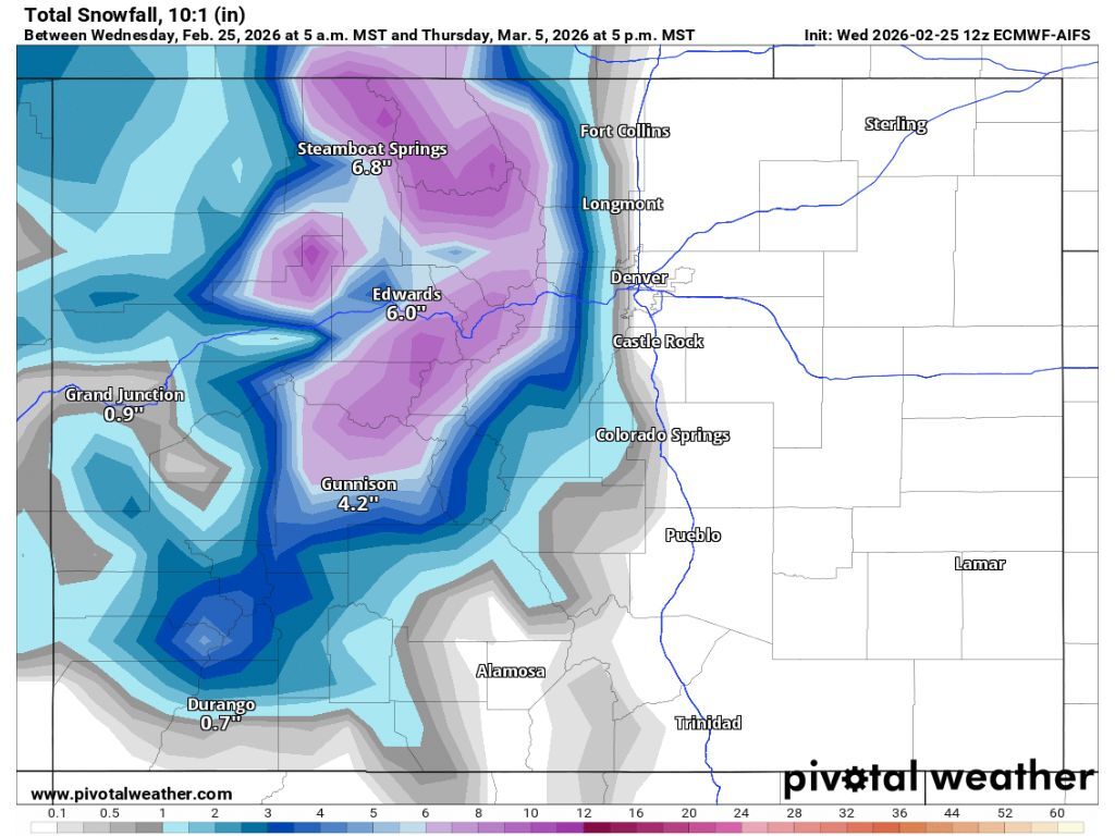
Between 5 p.m. on March 5 and 5 p.m. on March 6, Pivotal Weather is calling for Denver to get 12.3 inches of snow, with 9.1 inches expected in Fort Collins during the same period along with 10.3 in Castle Rock and 5.5 in Colorado Springs. If this scenario holds true, totals in the Mile High City will rival those that mountain peaks around the state will have gotten over the week-plus prior to this storm.
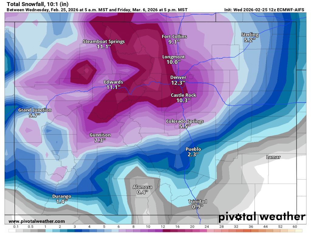
Keep in mind that this storm is still more than a week out, so a lot can change between now and then. If this storm holds true though, expect travel issues in Denver during the tail-end of the first week of March.
As of February 25, Colorado’s snowpack sits at 63 percent of the norm for the date with a snow-water equivalent of 7.8 inches. That snow-water equivalent ties that of February 25, 2002 at a record low for the date.
STAY INFORMED: Get free Colorado news with our daily newsletter (Click here)
Get OutThere
Signup today for free and be the first to get notified on new updates.
PREV
PREVIOUS

Denver isn't the biggest city in Colorado and it might not be state's most populous much longer either
Ask the average person what Colorado’s largest city is and they’ll probably respond with “Denver… obviously.” Believe it or not, they’re wrong. Keep in mind we’re talking size, not population, and that we’re talking the actual city of Denver, not the Denver metro area. Under those terms, the largest city in Colorado is, in fact, […]
Latest map shows wolves exploring new parts of southern Colorado
Colorado Parks and Wildlife has released their wolf tracking map that accounts for January 27 through February 24 and there are several interesting takeaways. Before digging into this map, it’s crucial to note that the inclusion of any highlighted area does not mean that wolves were present in the entire highlighted area, merely that at […]