


14-plus inches of snow could hit some Colorado peaks over upcoming days
Widespread snowfall is expected to move through the state over coming days, with a more significant wave of snow likely to start on Sunday and continue into next week.
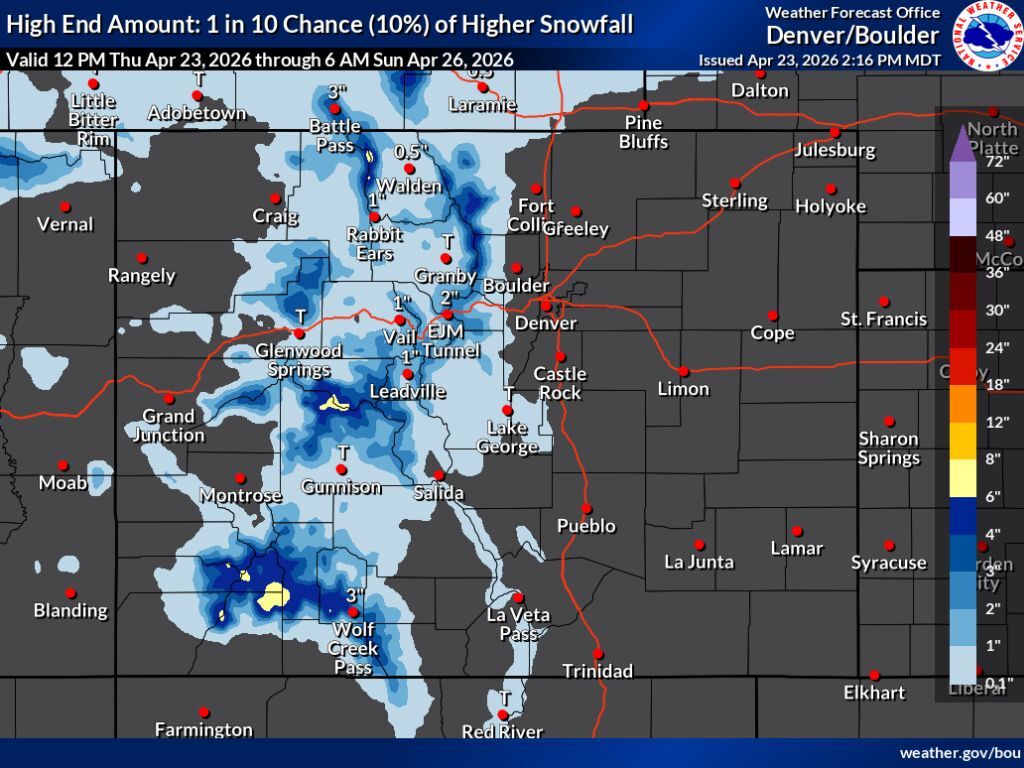
According to the National Weather Service, on-and-off snow through Sunday morning should drop flurries around much of Colorado’s high country, though most areas should be limited to four inches or less – even in the ‘high-end’ scenario. There is a chance that some peaks in southwest Colorado and the Elks near Aspen could get about six to eight inches during this period, but that only happens if the 10% chance high-end scenario comes to fruition. That said, more significant snow should soon follow.
What’s more interesting is the snow that’s set to start on Sunday. Pivotal Weather mapping shows that this round of snow could bring about six to eight inches to many peaks in the western half of the state by Monday morning, mostly missing the Front Range and Sangre de Cristos. Totals continue to climb into Tuesday morning, and at that point, the Flat Tops could have about 14 inches of snow, with about 10 to 11 inches having fallen on other western peaks. Again, the Front Range and Sangre de Cristos get mostly missed.
Pivotal Weather mapping shows that this round of snow continues until mid-day on Wednesday, and by that time, totals between now and then could reach up to 19 inches of snow in the Flat Tops and about 14 inches in the Elks. Small portions of the Park Range near Steamboat Springs could get about 13 inches and the San Juans could get about a foot. Front Range peaks and the Sangre de Cristos still get significantly less.
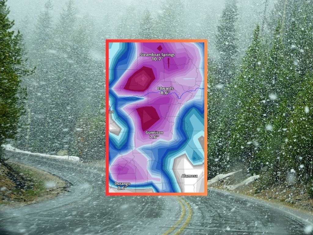
Not that it matters too much now that most ski areas have ended their seasons, but the OpenSnow five-day report does show similar totals in similar areas that Pivotal Weather predicts will get hit the hardest. The OpenSnow report shows southwest locations getting the most snow over the next five days, putting Wolf Creek and Silverton at 15 and 14 inches, respectively. Meanwhile, Arapahoe Basin – known for its late-season skiing – only gets five.
As of April 23, Colorado’s snowpack is at just 16 percent of the long-term norm for the date per the USDA – on par with what’s typical for June 2 or June 3. Some river basins are even worse off – the Arkansas River Basin, for example, which is at 9 percent of the typical norm for April 23.
Expect the National Weather Service to publish maps accounting for this next wave of snow at some point leading into or during the weekend – it’ll be interesting to see whether or not it varies from the Pivotal Weather prediction. Find National Weather Service forecasts here.
STAY INFORMED: Get free Colorado news with our daily newsletter (Click here)
Get OutThere
Signup today for free and be the first to get notified on new updates.
PREV
PREVIOUS

Officials say animal attack, foul play, and self harm not suspected in case of missing Colorado hunter
The Chaffee County Sheriff’s Office has released some additional information in the ongoing search for turkey hunter Kaden Sites, 27, in the area of Mount Shavano. According to the latest update, a 275-acre area of National Forest land found north of the Weldon Creek subdivision and northwest of Poncha Springs was searched. This was described […]

Breck set to reopen for one last surprise day of skiing and snowboarding
It looked like Breckenridge Resort’s last day of skiing and snowboarding for the season would be April 19, but per a surprise April 23 announcement, one of the spot’s lifts is set to spin again. According to Breckenridge Resort, Colorado SuperChair will operate on Peak 8 on Saturday, April 25, providing access to Middle 4 […]