


Happy Trails: This southern Colorado mountain could be just the challenge you’re seeking

Humboldt Peak is a great introduction to Class 2 climbing in Colorado. Photo by Mark Reis, Special to The Gazette
Mark Reis, Special to The Gazette


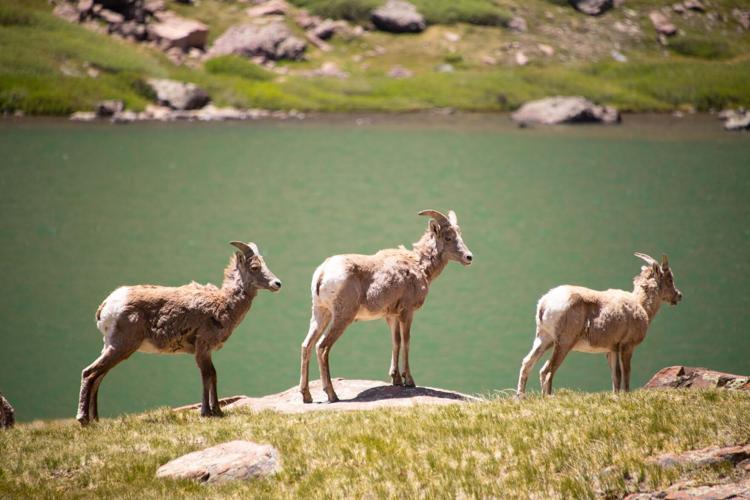


A herd of bighorn sheep enjoys a sunny afternoon in the Sangre de Cristo mountain range in southern Colorado on July 1, 2020. (Video by Nathan Van Dyne, The Gazette; photos by Mark Reis, Special to The Gazette)
{
“@context”: “https://schema.org”,
“@type”: “VideoObject”,
“name”: “Bighorn Bash in Colorado”,
“description”: “A herd of bighorn sheep enjoys a sunny afternoon in the Sangre de Cristo mountain range in southern Colorado on July 1, 2020. (Video by Nathan Van Dyne, The Gazette; photos by Mark Reis, Special to The Gazette)”,
“thumbnailUrl”: “https://bloximages.newyork1.vip.townnews.com/denvergazette.com/content/tncms/assets/v3/editorial/0/12/01246a79-6bfc-55c0-82bb-9e82fcad4f45/5f3705e59037e.image.jpg?resize=1396%2C785”,
“uploadDate”: “2020-07-19T20:58:00-06:00”,
“contentUrl”: “https://cdn.field59.com/GAZETTE/a872c50aaed886a926b10f91c084dcbe78a59d13_fl9-360p.mp4”
}
Humboldt Peak
You’ve taken Barr Trail from Manitou Springs to the top of America’s Mountain. You’ve conquered Grays and Torreys in a single day. Your fourteener passport even includes the rare air of Mount Elbert, at 14,433 feet the highest peak in Colorado.
But perhaps you’re looking for a tougher test. Not one named Longs, Capitol or Little Bear, but one that ventures into more difficult terrain than Pikes Peak.
Look no further than Humble Humboldt. This mountain in southern Colorado is a great introduction to Class 2 climbing and the easiest (by far) in the Crestone group of the Sangre de Cristo range.
Happy Trails: Maybe the best Colorado Springs-area hike that you haven’t tried
While its nickname might suggest a laid-back experience, Humboldt requires some route-finding and also presents the possibility of danger due to moderate exposure and potential rockfall.
From the upper trailhead (the lower trailhead tacks on a hefty amount of mileage and elevation gain), follow the four-wheel-drive road along the creek and through the trees. After 2.5 miles, veer right at the junction and follow the singletrack to South Colony Lakes.
With Crestone Needle towering above and a herd of bighorn sheep often lounging near the shore, it’s a quintessential Colorado postcard. Enjoy it for a while, but the crux of the hike awaits.
Happy Trails: Short, steep trail west of Colorado Springs sure to take your breath away
The trail switchbacks above treeline to the ridge. Follow the path east to rock outcroppings frequented by marmots. From here, be on the lookout for cairns and segments of trail that will guide you first to the false summit and then on to the top.
Relish the stunning views and return the way you came.
Trip log: 11.5 miles round trip (from upper trailhead), 4,295 feet elevation gain, 14,064 feet max
Difficulty: Difficult
FYI: High-clearance, 4WD vehicle needed to reach upper trailhead. Dogs on leash. No restrooms at trailhead.
NATHAN VAN DYNE, THE GAZETTE