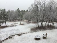
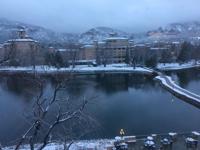
The fourth-largest snowstorm in Denver’s history came to an end Monday, leaving the the Denver metro area to dig out from under more than two feet of heavy, wet snow.
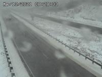
The slow-moving gusty weekend storm pounded areas of Colorado, leaving 27.1 inches of snow at Denver International Airport, canceling flights, shutting down interstate highways and stranding motorists. Interstate 25, which was closed Sunday between Castle Rock and Colorado Springs because of white-out conditions, remained closed until mid-morning Monday. Interstate 70 east of Denver was closed for several hours.
The National Weather Service announced the official end of the snowstorm at 6:25 a.m. Monday; however, more snow is predicted for Tuesday afternoon as well as the weekend.
Stranded vehicles littered major highways as the Colorado State Patrol worked to tow them throughout the day
“We can certainly say despite asking folks to stay off the roadways, we did handle hundreds of calls statewide each day dealing with crashes, slide offs, stuck and stranded motorists, and more,” Trooper Joshua Lewis said.
To find vehicles left on highways, drivers should return to the area where they left their vehicle and travel in the same direction, taking the first exit available, officials said. Towed vehicles will be moved to the largest parking lot from the off-ramp. For those unable to locate their vehicle, Colorado State Patrol will provide a complete list of tow companies used in this storm once it is compiled.
Denver remained on accident alert until Monday morning as the area suffered from icy and snow-packed roads and low visibility. According to the Denver Police Department, officers responded to 60 stuck vehicles from Saturday to Monday, including 50 at Denver International Airport. Officers rescued more than 100 people from their cars.
Bison graze for food near Kremmling, Colo., as a winter storm continues into the morning Monday, March 15, 2021. Much of Colorado was hit by a major winter storm over the weekend bringing as much as 40 inches of snow in parts of the state and closing major highways including Interstate 70 and Interstate 25. (The Gazette, Christian Murdock)
Clouds roll over a snow-covered 14,115-foot Pikes Peak as seen from Woodland Park Monday, March 15, 2021, as a winter storm clears out of the area. Woodland Park recorded 23 inches of snow from the weekend storm. (The Gazette, Christian Murdock)
Clouds roll over a snow-covered 14,115-foot Pikes Peak as seen from Woodland Park Monday, March 15, 2021, as a winter storm clears out of the area. Woodland Park recorded 23 inches of snow from the weekend storm. (The Gazette, Christian Murdock)
Alex Nauman, top right, Dave Mehta, left, and another good samaritan pull Kirk Cyborowski and his wife out of the deep snow in the meridian between the east and westbound lanes of U.S. Highway 24 near Woodland Park Monday, March 15, 2021. Cyborowski, who lives in Lake George, was driving his wife, who has cancer, to the hospital when he hit the deep slush on the roadway and spun into the snow bank. ( The Gazette, Christian Murdock)
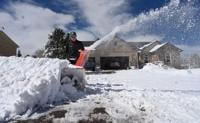
Thatcher Mills digs out his driveway with his snowblower after heavy wet snow hit the Highlands Ranch area Sunday, March 14, 2021. Many residents in Highlands Ranch were out shoveling and using snow blowers.
A lone car sits on the side of highway 285 after spinning out in the snow as a snowplow passes on the other side of the highway near Conifer on March 13, 2021. By 6 p.m. on Saturday, several inches of snow had accumulated in the foothills west of Denver, and for the Denver metro area, several dozen inches of snow were forecast to fall through the end of the weekend. (Forrest Czarnecki/The Gazette)
The St. Patrick’s Day was canceled for the second year in a row, but a 5K for St. Patrick’s Day was run no matter what the weather. Runners starts were staggered and after the race started large snowflakes started to drop in downtown on Saturday, March 13, 2021. (Photo by Jerilee Bennett, The Gazette)
The St. Patrick’s Day was canceled for the second year in a row, but a 5K for St. Patrick’s Day was run no matter what the weather. Runners starts were staggered and after the race started large snowflakes started to drop in downtown on Saturday, March 13, 2021. (Photo by Jerilee Bennett, The Gazette)
The St. Patrick’s Day was canceled for the second year in a row, but a 5K for St. Patrick’s Day was run no matter what the weather. Runners starts were staggered and after the race started large snowflakes started to drop in downtown on Saturday, March 13, 2021. (Photo by Jerilee Bennett, The Gazette)
The St. Patrick’s Day was canceled for the second year in a row, but a 5K for St. Patrick’s Day was run no matter what the weather. Runners starts were staggered and after the race started large snowflakes started to drop in downtown on Saturday, March 13, 2021. (Photo by Jerilee Bennett, The Gazette)
The St. Patrick’s Day was canceled for the second year in a row, but a 5K for St. Patrick’s Day was run no matter what the weather. Runners starts were staggered and after the race started large snowflakes started to drop in downtown on Saturday, March 13, 2021. (Photo by Jerilee Bennett, The Gazette)
The St. Patrick’s Day was canceled for the second year in a row, but a 5K for St. Patrick’s Day was run no matter what the weather. Runners starts were staggered and after the race started large snowflakes started to drop in downtown on Saturday, March 13, 2021. (Photo by Jerilee Bennett, The Gazette)
The St. Patrick’s Day was canceled for the second year in a row, but a 5K for St. Patrick’s Day was run no matter what the weather. Runners starts were staggered and after the race started large snowflakes started to drop in downtown on Saturday, March 13, 2021. (Photo by Jerilee Bennett, The Gazette)
Slush and snow snarled Interstate 25 over Raton Pass Saturday morning. The Colorado Department of Transportation has advised drivers to stay home while a weekend storm slams the state. (Colorado Department of Transportation)
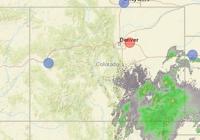
A radar image from the National Weather Service shows moisture surging into Colorado from the southeast. That’s expected to bring heavy snow to the Front Range and thunderstorms to the plains.
Clouds conceal Pikes Peak from view off Circle Drive in Colorado Springs Saturday morning as Colorado braced for a winter storm. Tom Roeder / The Gazette
A ridgeline near Kittredge disappears into the low clouds and fog on March 13, 2021. The Denver area and Front Range foothills are forecasted to see anywhere from 20 inches to three feet of snow throughout the weekend but by noon on Saturday, it was lightly snowing with minimal accumulation in the Denver area. (Forrest Czarnecki/The Gazette)
A ridgeline along the Hogback Mountains near Morrison disappears into the low clouds and fog on March 13, 2021. The Denver area and Front Range foothills are forecasted to see anywhere from 20 inches to three feet of snow throughout the weekend but by noon on Saturday, it was lightly snowing with minimal accumulation in the Denver area. (Forrest Czarnecki/The Gazette)
Horses clad in their blankets feed during the beginnings of the snowstorms near Hwy. 83 north of Black Forest on Saturday, March 13, 2021. (Photo by Jerilee Bennett, The Gazette)
Traffic heads southbound through the fog and sleet on Monument Hill at dusk near County Line Rd. on Saturday, March 13, 2021. (Photo by Jerilee Bennett, The Gazette)
A man who declined to give his name clears snow from the front sidewalk of the King Soopers in Conifer on March 13, 2021. By 6 p.m. on Saturday, several inches of snow had accumulated in the foothills west of Denver, and for the Denver metro area, several dozen inches of snow were forecast to fall through the end of the weekend. (Forrest Czarnecki/The Gazette)
A car sits on the side of the road after spinning out in the snow while other vehicles pass by near Conifer on March 13, 2021. By 6 p.m. on Saturday, several inches of snow had accumulated in the foothills west of Denver, and for the Denver metro area, several dozen inches of snow were forecast to fall through the end of the weekend. (Forrest Czarnecki/The Gazette)
A sign advertising firewood for sale contrasts against the heavy snowfall near Conifer on March 13, 2021. By 6 p.m. on Saturday, several inches of snow had accumulated in the foothills west of Denver, and for the Denver metro area, several dozen inches of snow were forecast to fall through the end of the weekend. (Forrest Czarnecki/The Gazette)
A lone car sits on the side of highway 285 after spinning out in the snow near Conifer on March 13, 2021. By 6 p.m. on Saturday, several inches of snow had accumulated in the foothills west of Denver, and for the Denver metro area, several dozen inches of snow were forecast to fall through the end of the weekend. (Forrest Czarnecki/The Gazette)
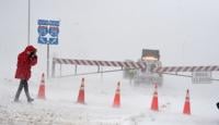
Highway 24, east of Constitution Ave. in Colorado Springs, is closed on Sunday morning because of blowing snow. A CDOT truck sits at the road block as a snow plow truck heads east towards Falcon on Sunday, March 14, 2021. (Photo by Jerilee Bennett, The Gazette)
Highway 24, east of Constitution Ave. in Colorado Springs, is closed on Sunday morning because of blowing snow on Sunday, March 14, 2021. (Photo by Jerilee Bennett, The Gazette)
Even though there’s a blizzard, nature still calls for this dog and dog owner at an apartment complex near Interquest Pkwy. on Sunday, March 14, 2021. (Photo by Jerilee Bennett, The Gazette)
A front end loader tries to keep up on the falling and blowing snow near Interquest Pkwy. on Sunday, March 13, 2021. (Photo by Jerilee Bennett, The Gazette)
Stu Spath of Centennial cross country skis to Vasa Fitness on County Line Road for a morning swim as snow continues to fall after dumping several inches of snow overnight. Stu says its about a 2-mile trek to the gym.
Left to right are Dayne Schmittel, Delilah West 9 years old and Chad Laine head up the hill Sunday, March 14, 2021, for a quick run down Ruby Hill, a favorite place for sledders to go. The blowing snow made it difficult to and stand as snow continued to fall in the Denver metro area
After going to ask a CDOT worker about the opening of I-25, Traveler Tom Nielsen realized he cannot find any way north. The Interquest Pkwy. was shut down on I-25 North on Sunday afternoon, March 14, 2021. (Photo by Jerilee Bennett, The Gazette)
After a semi-truck from St. Louis got diverted from I-25 at Interquest Pkwy., the driver got stuck on the parkway. A Good Samaritans named Rob and a truck driver named Craig helped him to get out on Sunday, March 14, 2021. (Photo by Jerilee Bennett, The Gazette)
Even though there’s a blizzard, nature still calls for this dog and dog owner at an apartment complex near Interquest Pkwy. on Sunday, March 14, 2021. (Photo by Jerilee Bennett, The Gazette)
A front end loader tries to keep up on the falling and blowing snow near Interquest Pkwy. on Sunday, March 13, 2021. (Photo by Jerilee Bennett, The Gazette)
Two vehicles that were stuck between an outer road and I-25 wait for removal on Monday, March 15, 2021. near Castle Rock was still waiting for removal on Monday, March 15, 2021. All the vehicles that were stuck on I-25 were removed by the time the interstate reopened on Monday morning. There were still vehicles on the outer roads that were still waiting for removal. (Photo by Jerilee Bennett, The Gazette)
Shortly after I-25 reopens, a line of semi’s that were stuck on the northbound offramp of Woodmen Rd. wait for the north onramp to reopen so they can get on their way on Monday, March 15, 2021. (Photo by Jerilee Bennett, The Gazette)
A car that may have been exiting on the off ramp to Tomah Rd. near Castle Rock was still waiting for removal on Monday, March 15, 2021. All the vehicles that were stuck on I-25 were removed by the time the interstate reopened on Monday morning. There were still vehicles on the outer roads that were still waiting for removal. (Photo by Jerilee Bennett, The Gazette)
Two vehicles that were stuck between an outer road and I-25 wait for removal on Monday, March 15, 2021. near Castle Rock was still waiting for removal on Monday, March 15, 2021. All the vehicles that were stuck on I-25 were removed by the time the interstate reopened on Monday morning. There were still vehicles on the outer roads that were still waiting for removal. (Photo by Jerilee Bennett, The Gazette)
A car that may have been exiting on the off ramp to Tomah Rd. near Castle Rock was still waiting for removal on Monday, March 15, 2021. All the vehicles that were stuck on I-25 were removed by the time the interstate reopened on Monday morning. There were still vehicles on the outer roads that were still waiting for removal. (Photo by Jerilee Bennett, The Gazette)
These two cars made it to Beacon Lite Rd. before they got stuck on Monument Hill off of County Line Rd. On Monday, March 15, 2021. All the vehicles that were stuck on I-25 were removed by the time the interstate reopened on Monday morning. There were still vehicles on the outer roads that were still waiting for removal. (Photo by Jerilee Bennett, The Gazette)
A vehicle that made it as far as Beacon Lite Rd. and County Line Rd. was still stuck on Monday, March 15, 2020. All the vehicles that were stuck on I-25 were removed by the time the interstate reopened on Monday morning. There were still vehicles on the outer roads that were still waiting for removal. (Photo by Jerilee Bennett, The Gazette)
A snowplow clears the southbound shoulders near Monument Hill on I-25 on Monday, March 15, 2021. All the vehicles that were stuck on I-25 were removed by the time the interstate reopened on Monday morning. There were still vehicles on the outer roads that were still waiting for removal. (Photo by Jerilee Bennett, The Gazette)
A snowplow clears the offramp near Monument Hill on I-25 on Monday, March 15, 2021. All the vehicles that were stuck on I-25 were removed by the time the interstate reopened on Monday morning. There were still vehicles on the outer roads that were still waiting for removal. (Photo by Jerilee Bennett, The Gazette)
Good Samaritan neighbors Larry Most and the Scott family were clearing the entrance and driveway of an elderly couple near County Line Rd. In Monument on Monday, March 15, 2021. Some areas of Monument got almost 20 inches of snow during the weekend blizzard. (Photo by Jerilee Bennett, The Gazette)
Good Samaritan neighbors Daniel Scott and his mother, Mary Scott, were clearing the entrance and driveway of an elderly couple near County Line Rd. In Monument on Monday, March 15, 2021. Some areas of Monument got almost 20 inches of snow during the weekend blizzard. (Photo by Jerilee Bennett, The Gazette)
Good Samaritan neighbors Larry Most (front) and Craig Scott use snow blowers to clear the driveway of an elderly couple near County Line Rd. In Monument on Monday, March 15, 2021. Some areas of Monument got almost 20 inches of snow during the weekend blizzard. (Photo by Jerilee Bennett, The Gazette)
Aaron Kellar excavates the snow from his driveway near County Line Rd. In Monument on Monday, March 15, 2021. Some areas of Monument got almost 20 inches of snow during the weekend long blizzard. (Photo by Jerilee Bennett, The Gazette)
Good Samaritan neighbors Oliver Scott and his mother, Mary Scott,were clearing the entrance and driveway of an elderly couple near County Line Rd. In Monument on Monday, March 15, 2021. Some areas of Monument got almost 20 inches of snow during the weekend blizzard. (Photo by Jerilee Bennett, The Gazette)
A bison is covered in snow as it grazes for food near Kremmling, Colo., during a winter storm Monday, March 15, 2021. Much of Colorado was hit by a major winter storm over the weekend bringing as much as 40 inches of snow in parts of the state and closing major highways including Interstate 70 and Interstate 25. (The Gazette, Christian Murdock)
Bison graze for food near Kremmling, Colo., as a winter storm continues into the morning Monday, March 15, 2021. Much of Colorado was hit by a major winter storm over the weekend bringing as much as 40 inches of snow in parts of the state and closing major highways including Interstate 70 and Interstate 25. (The Gazette, Christian Murdock)
Clouds roll over a snow-covered 14,115-foot Pikes Peak as seen from Woodland Park Monday, March 15, 2021, as a winter storm clears out of the area. Woodland Park recorded 23 inches of snow from the weekend storm. (The Gazette, Christian Murdock)
Clouds roll over a snow-covered 14,115-foot Pikes Peak as seen from Woodland Park Monday, March 15, 2021, as a winter storm clears out of the area. Woodland Park recorded 23 inches of snow from the weekend storm. (The Gazette, Christian Murdock)
Alex Nauman, top right, Dave Mehta, left, and another good samaritan pull Kirk Cyborowski and his wife out of the deep snow in the meridian between the east and westbound lanes of U.S. Highway 24 near Woodland Park Monday, March 15, 2021. Cyborowski, who lives in Lake George, was driving his wife, who has cancer, to the hospital when he hit the deep slush on the roadway and spun into the snow bank. ( The Gazette, Christian Murdock)
Thatcher Mills digs out his driveway with his snowblower after heavy wet snow hit the Highlands Ranch area Sunday, March 14, 2021. Many residents in Highlands Ranch were out shoveling and using snow blowers.
A lone car sits on the side of highway 285 after spinning out in the snow as a snowplow passes on the other side of the highway near Conifer on March 13, 2021. By 6 p.m. on Saturday, several inches of snow had accumulated in the foothills west of Denver, and for the Denver metro area, several dozen inches of snow were forecast to fall through the end of the weekend. (Forrest Czarnecki/The Gazette)
RTD suspended all bus services Monday because of the poor road conditions. Light rail services continued with delays, expect for the R Line which closed Monday when excessive snow remained on portions of the track.
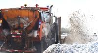
About 60 plows worked to clear the Denver metro area roads, including 23 residential plows targeting neighborhood streets, officials said.
“CDOT, county, and city plows are all out working hard to clear the roads the best they can, but we would like to reiterate to please stay home if you are able,” Colorado State Patrol officials said. “Many drivers have ventured out and slid off the roadway or crashed because it is very slick out.”
Hundreds of flights out of Denver were cancelled or delayed as crews worked to treat the runways for ice and snow. All of the airport’s runways were closed until 2 p.m. Monday.
The storm also resulted in extensive power failures throughout the state, with tens of thousands of Coloradans without electricity Sunday, according to Xcel Energy data.
By Monday afternoon, 10,000 residents were still without power near Greeley, 1,500 near Fort Collins and 260 near Denver, according to Xcel, which cited heavy snow and high winds displacing power lines and damaging utility poles as some causes for the power failures. Some utility poles have also been damaged by drivers crashing into them while sliding off of icy roads.
“One of the reasons this storm was so impactful was that it produced heavy, wet snow,” the National Weather Service reported. “This type of snow is able to easily stick to objects like power lines and branches.”
The storm likely made a good dent in this year’s drought conditions, especially in the east where 2 to 3 inches of rain was recorded near Lamar, said Kyle Mozley, a meteorologist with the National Weather Service in Pueblo.
Even so, improving the dry conditions depends on the months to come.
“If we keep continuing to get these storms to roll through, then it probably will alleviate some of that drought,” Mozley said. “But if it is just a one-and-done and it stays dry, the drought is going to persist.”
State Climatologist Russ Schumacher called the storm “very significant” for northern Colorado and the eastern plains in terms of moisture. The storm brought the wettest day in over 18 months to places such as Kiowa County, he said. Snowpack got a large boost to the east of the Continental Divide, which he said will help recharge the soil moisture in the agricultural areas of eastern Colorado.
“So this will definitely make a difference with respect to our ongoing drought in those spots,” Schumacher said. “West of the Divide, though, there wasn’t nearly so much snow, and those are the areas that both have worse drought conditions and are where most of our water comes from, even for us east of the Divide.”
As far as what the summer months may look like, following one filled with wildfires that tore through the state, Schumacher said it’s still “too early to say.”
“The outlooks for the rest of spring and summer still point toward warm and dry conditions, but there’s always a lot of uncertainty with those so we’re just going to need to wait and see how the next few months play out …,” he said.
As snow began to melt and skies cleared along the Front Range, meteorologists shifted their focus to the incoming storm, which is likely to bring more snow Tuesday.
The biggest snow totals are expected in southern Colorado, near the New Mexico border, where between 10 inches to a foot of snow is possible, officials said.
The Gazette’s Olivia Pretzel contributed to this report.
MILAN – The “Quad God” crashed to earth with an icky thump. How the heck did that happen? “I blew it,” U.S. figure skater Ilia Malinin said Friday. He not only failed to win gold that had been deemed a...
Nicole C. Brambila nico.brambila@denvergazette.com
nico.brambila@denvergazette.com
Updated 7 hours ago
Amid heightened public scrutiny following recent leadership upheaval, the Cherry Creek School District will launch an independent audit of its internal controls and impose stricter contract approval rules, lowering the dollar threshold for board oversight and requiring additional executive and...
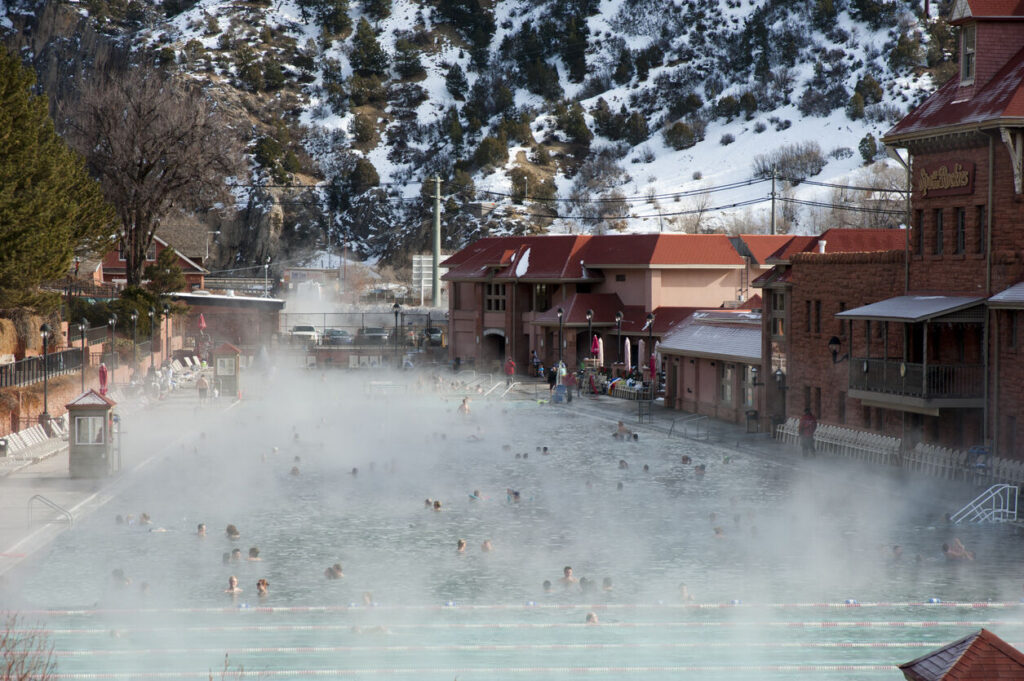
Whether you’re looking to soothe tired muscles after a long ski day or simply looking for a relaxing winter activity, a soak in a hot springs is an excellent choice. Colorado has a variety of hot springs that offer everything...
It may be a short work week, but the Denver City Council will still have a robust agenda on Tuesday after Presidents’ Day. For those following Council Bill 26-0125, the Safety and Transparency in Public Authority Act, which proposes to...
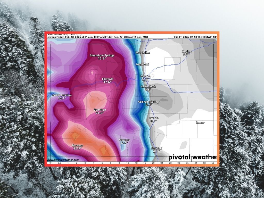
Over the last three days, big snow has fallen in several key parts of Colorado’s ski country, including about 30 inches on some select peaks in the Aspen area and between 18 and 24 inches on peaks near Steamboat Springs....
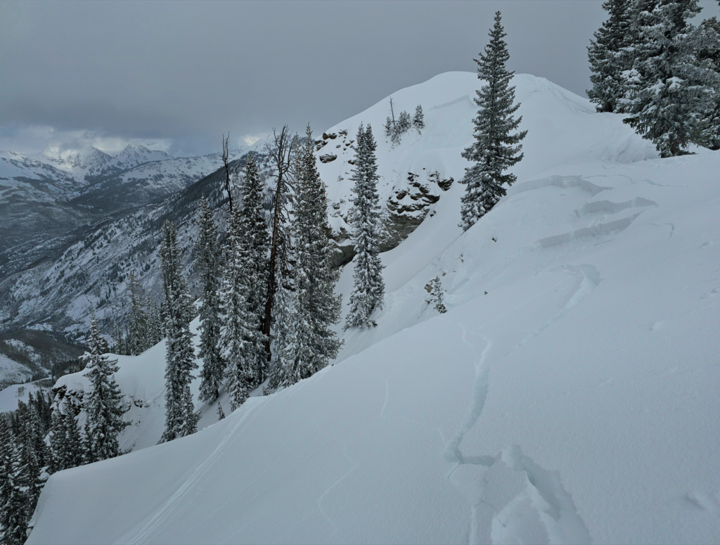
Colorado avalanche officials warn of a dangerous Presidents’ Day weekend in the backcountry, aligning with historic trends in the state. The long weekend is expected to bring the highest levels of avalanche danger Colorado has seen so far in February,...
Aurora Fire Rescue recently adopted a new response program that integrates telehealth into 911 dispatch, connecting non-emergency medical callers with physicians. The new service, Aurora Clinical Navigation, uses a platform called MD Ally to connect 911 callers experiencing non-emergency medical...
Niko Medved is thinking about a weekend he never wanted to end. It’s been a week full of déjà vu for the former Colorado State coach, now in his first season at Minnesota. First, his Golden Gophers hosted Maryland on...
A Denver man was sentenced to 40 years in prison Friday for a murder-for-hire plot against his wife while he was in jail. Yaury Hill, 34, pleaded guilty Feb. 6 for trying to convince his roommate to kill his wife...
Thornton Police Department officers arrested a man on suspicion of attempted murder Wednesday after he led them on a chase. Ismael Barajas Aguilar, 39, faces attempted murder, assault, domestic violence and resisting arrest charges after he allegedly shot a woman...


