Live weather blog: Multiple Colorado Springs-area school districts on 2-hour delay after snowstorm
Numerous Colorado Springs-area school districts along with local military installations are on delayed starts Tuesday after the snowstorm that rolled through southern Colorado on Monday.
Fort Carson and the Air Force Academy are on delayed reporting status.
Among the schools with two-hour delays: District 49, Academy District 20, Cheyenne Mountain 12, Colorado Springs District 11, Manitou Springs District 14 and Lewis-Palmer District 38, Fountain-Fort Carson District 8 and Widefield District 3.
Several other public agencies and faith-based organizations are also delaying their openings Tuesday morning.
Click here for the latest list of delays.
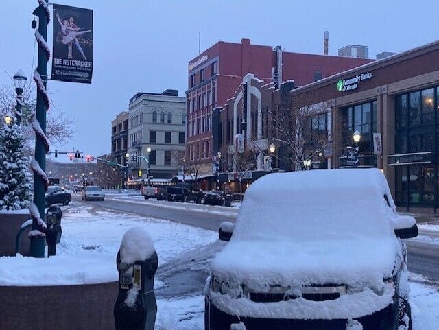
Parts of Colorado Springs received 5-plus inches of snow Monday and into early Tuesday; Woodland Park had 6-plus, according to the National Weather Service in Pueblo.
Snow totals in the Pikes Peak region: Monday, Dec. 9
Tuesday forecast
Sunny skies are forecast to return Tuesday with a high temperature of 34 degrees in Colorado Springs, according to the National Weather Service, with Wednesday expected to reach 45.
Colorado Springs weather: Cold and breezy Tuesday around the Pikes Peak region
9:30 p.m. Monday update
Colorado Springs remains under a Winter Weather Advisory until 10 p.m., while some areas have seen up to 5 inches of snowfall so far on Monday, according to the National Weather Service in Pueblo.
The snow so far has made for hazardous driving conditions. A spokesperson with the Colorado Springs Fire Department said Monday afternoon that crews had responded to at least 35 traffic crash calls for services across the city. Several have involved multiple vehicles and caused closures and delays on major roadways.
Closures and delays
Multiple school districts are on a 2-hour delay for Tuesday morning, including Academy District 20, Colorado Springs School District 11, Cheyenne Mountain District 12, District 49, Harrison District 2, Hanover 28 and Manitou Springs School District 14.
Fort Carson and Peterson and Schriever Space Force Base will also be on a 2-hour delay Tuesday. Fort Carson soldiers report by 9 a.m. Click here for an updated closings list.
Mountain Metro Transit buses will start service at 9 a.m. Tuesday, according to a news release. The delay is for both regular buses and ADA paratransit service. Due to predicted icy road conditions, residents should expect detours and delays.
Snowstorm causes traffic snarls in Colorado Springs
Lanes on I-25 reopen following crash
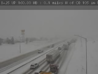
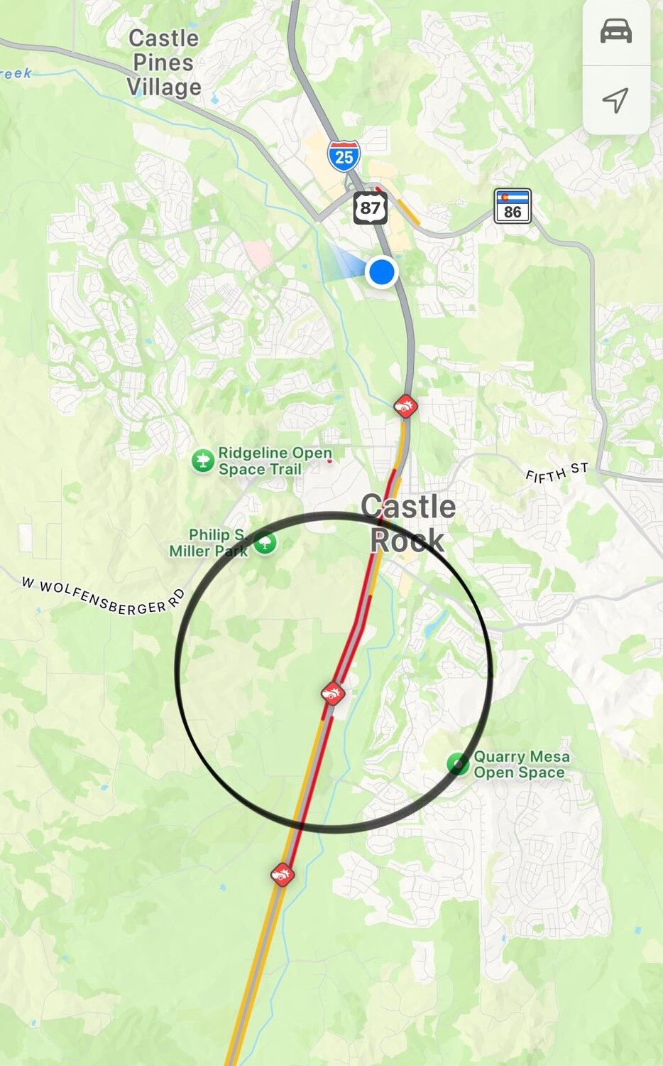
A three-lane closure of I-25 at Castle Rock has been cleared as of 6:30 p.m. According to the Colorado Department of Transportation, the blockage was between exit 182 and 184 due to a crash.
Monday morning, I-25 was shut down at Plum Creek Parkway, near mile marker 180, after multiple crashes, according to the Douglas County Sheriff’s Office. The lanes were reopened by 1 p.m.
Click here for updates from the Colorado Department of Transportation.
Tutt Boulevard reopens following crash
The Colorado Springs Police Department responded to a multi-vehicle crash on Tutt Boulevard near Tutt Center Place Monday. A spokesperson with the CSPD said the crash happened around 11:45 a.m. and involved about 10 cars. No injuries were reported.
Tutt Boulevard has since reopened.
Snowfall totals around Colorado Springs
Reported by the National Weather Service.
2.6″ – Air Force Academy as of 12 p.m.
4.5″ – NW Black Forest as of 2:34 p.m.
1″ – NW Peterson SFB as of 11 a.m.
5.4″ – Southwest Colorado Springs as of 3:20 p.m.
5″ – Broadmoor Bluffs as of 3:08 p.m.
Snow totals in the Pikes Peak region: Monday, Dec. 9
Warming shelter issued in Pueblo
A temporary emergency housing and shelter declaration has been issued for the city of Pueblo beginning at 7 p.m. Monday through 7 a.m. Dec. 16.
Accident reporting status
Both Colorado Springs and the city of Fountain have announced accident alert status.
“Road crews are on full call out but conditions are deteriorating,” read a statement posted by the CSPD on X.
Accident reporting allows drivers involved in a minor crash to make an online report in certain conditions. More information can be found here.
The forecast
After weekend temperatures in the 60s in Colorado Springs, a cold winter storm brought a significant change to the area early Monday morning.
Snowfall started during the morning commute and lasted through the early afternoon in the Pikes Peak region, bringing up to 5 inches in some areas. According to the NWS, heavy snow may continue to fall in the mountains south of Colorado Springs overnight.
Monday was also significantly colder and temperatures are expected to drop lower overnight, adding to hazardous road conditions. According to the National Weather Service in Pueblo, today’s high in Colorado Springs was forecast to be 29.
“On top of the snow, it will be much colder on Monday,” meteorologist Alan Rose with Gazette news partner KOAA said. “Highs today will only warm into the 30s in Colorado Springs and Pueblo, with middle to upper 20s in Woodland Park and the Tri-Lakes area.”
Kyle Mozley, a meteorologist with the National Weather Service in Pueblo, said one more small band of snow may bring added accumulation before tapering off Monday night.
“Everything winds down by 8 or 9 o’clock,” he said.
Behind Monday’s departing storm will come some very cold temperatures. Tuesday morning will start out in the teens in Colorado Springs, with single digit wind chills. Highs on Tuesday will only recover by a couple of degrees, topping out in the middle 30s.
“A return to near to above average highs will follow starting on Wednesday, with our late week temperatures in the upper 40s to lower 50s in the Colorado Springs area,” Rose said.