




Report calls for 3 to 5 feet of snow in Colorado over upcoming days
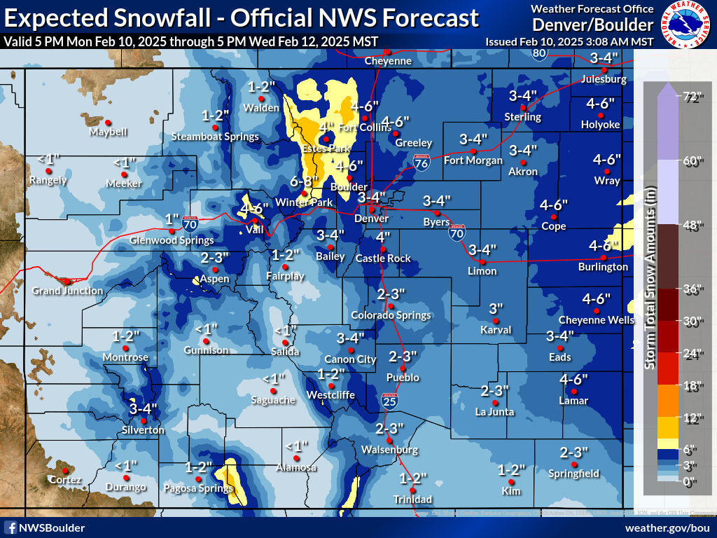
More snow is about to hit Colorado, according to the National Weather Service – and it could be very significant amid a relatively dry winter.
A first round of snow is expected to fall on and off from Monday evening through Wednesday, peaking between Tuesday night and Wednesday morning. Multiple bands of snow will be moving through the state during this period, with officials warning Coloradans about potentially slick commutes on the Front Range on Tuesday night and Wednesday morning.
Mapping shows that peaks along the Continental Divide north of I-70 should get the deepest totals in the most likely scenario for this first wave, along with peaks in the area of southwest Colorado’s Wolf Creek Pass. These totals should reach about a foot, with widespread snow ranging from flurries to six inches elsewhere.
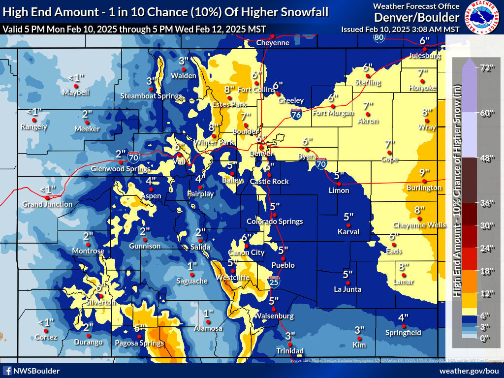
Meanwhile, in a high-end scenario, quite a bit of snow could fall in the Eastern Plains region, with totals of up to a foot possible along the state’s border with Kansas.
See maps depicting both scenarios below, and keep scrolling for information about more snow that might be on the way:
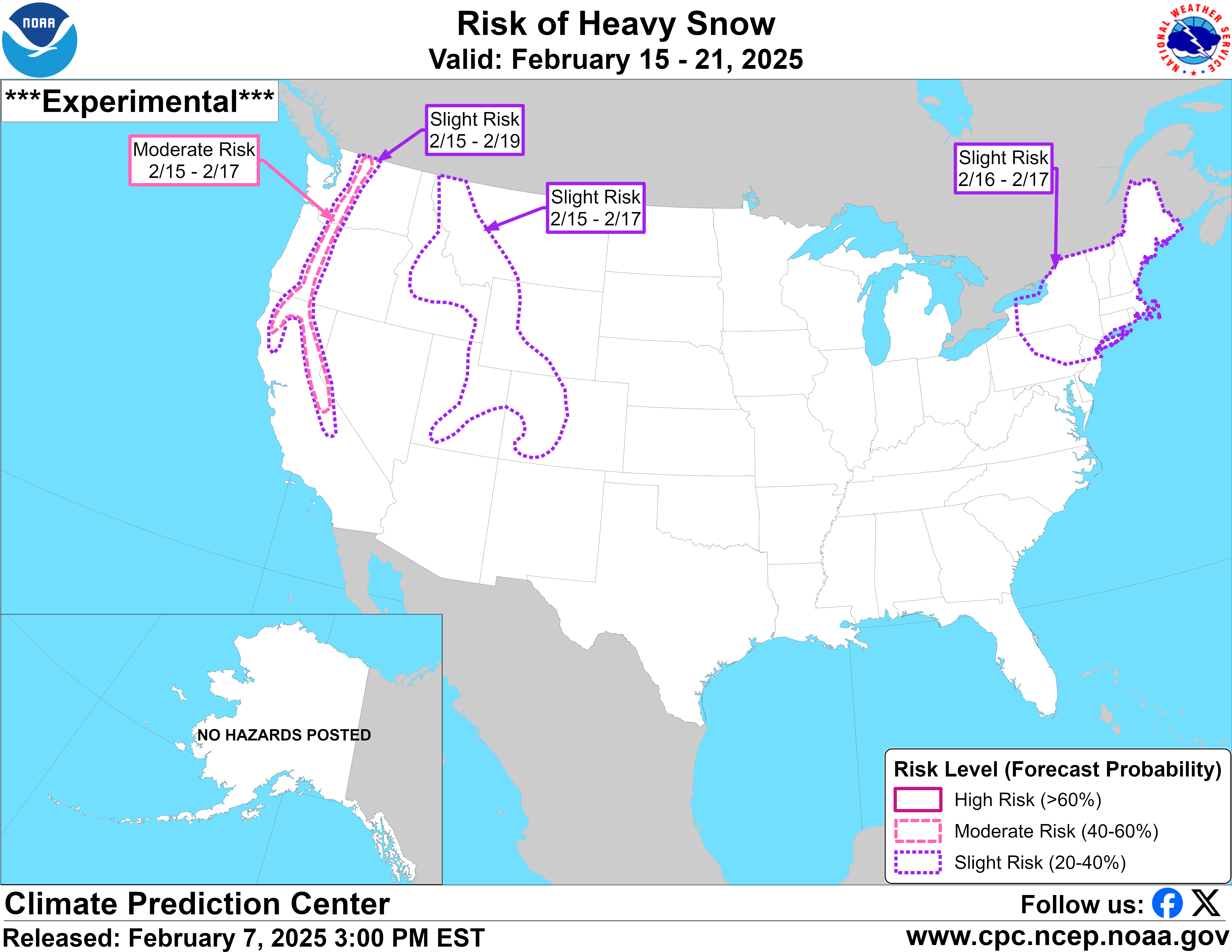
Following this round of snow to start the week, longer-term mapping indicates that heavy snow might be on the way this weekend. Much of Western Colorado is included on the ‘risk of heavy snow’ map from the National Weather Service for dates of February 15 through February 17.
The daily OpenSnow report helps to pin down how much snow can be expected through Friday at ski areas around the state, showing that Wolf Creek is likely to get the most fresh powder – to the tune of 31 inches. Keep in mind, that more snow will likely fall from Saturday through Monday, too.
A report from Denver Gazette’s Jonathan Ingraham indicates that between three and five feet of snow will be possible in the mountainous areas of central and southern Colorado through February 18.
As of February 10, statewide snowpack levels are at about 82 percent of the long-term norm for the date, with southwest Colorado being the region that’s lagging behind what’s typical the most at just 62 percent of the norm for the region. The help put these numbers into perspective, the state is in the 18th percentile compared to other snow seasons dating back to 1987. Meanwhile, southwest Colorado is in the 13th percentile.
Find additional weather information on the National Weather Service website.
Get OutThere
Signup today for free and be the first to get notified on new updates.
PREV
PREVIOUS
Annual 'camping report' shows decrease in 'no-shows' and increase in booking difficulties
The Dyrt has released its 2025 Camping Report, looking at the latest trends, topics, and figures related to the United States camping industry. The report shows that cancellations and no-shows dramatically decreased last year, allowing more people to enjoy the outdoors. As per the report, 81.1 million Americans camped in 2024, with 5.8 million of […]

Colorado zoo in the running for 'best zoo in US' vote
Cheyenne Mountain Zoo has once again been nominated as the ‘best zoo’ in the country as part of USA Today’s 10Best Readers’ Choice Awards. At time of publishing, the zoo was in third place on the leaderboard of 20 nominees from around the US. Readers can vote once per day until voting closes on March 10 […]