


Light snow to fall in Colorado before Thanksgiving, then heavy snow inbound as December starts
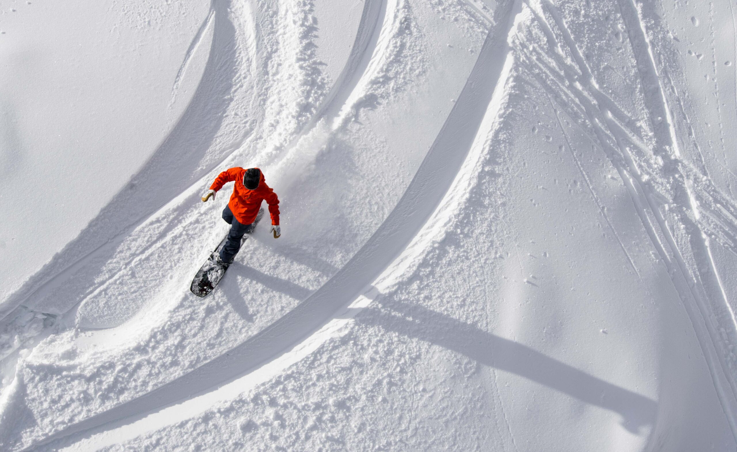
Winter returned to Colorado’s high country over the weekend, especially in the southern and central mountains.
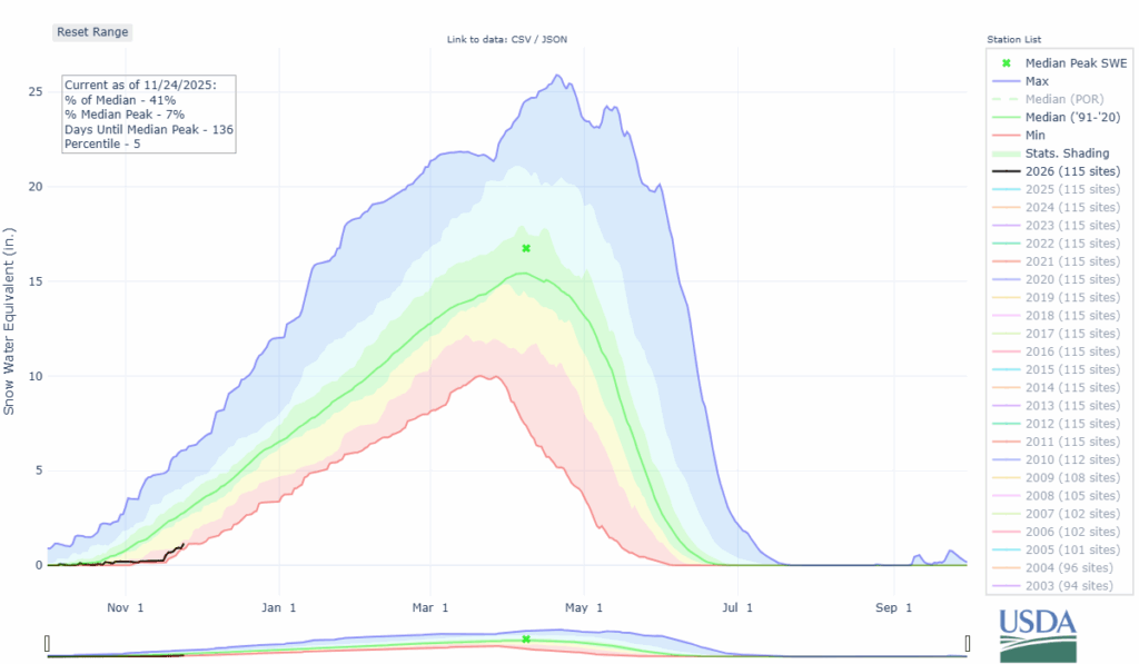
The state’s snowpack is slowly rebounding as well, with the median average moved above 33%.
Thanksgiving week forecast shows more snow through the holiday weekend, but a larger and heavier snow event is possible over the first couple of days of December.
Recap:
Five ski areas were supposed to open over the weekend, but due to lack of snow or other weather conditions, only two areas opened, Wolf Creek and Steamboat.
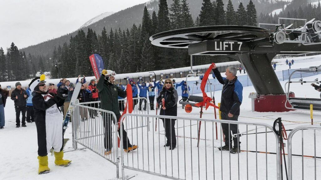
Loveland Ski Area officially opened the newly replaced Lift 7 to the public on Friday. “This new lift is all about creating a better experience for our guests,” Rob Goodell, COO and Senior Vice President of Loveland Ski Area said. “By giving beginners more space and time to get comfortable loading, we’re helping families and new skiers feel confident from their very first run.”
Snow returned to Colorado, especially southern Colorado, over the weekend as several inches fell for Sunday morning in the southern and central mountains; Wolf Creek reported eight inches and Monarch Mountain one inch at 8 a.m., but showed about six inches at 4:35 p.m.

Colorado’s snowpack:
The state’s snowpack started Sunday at 33% of median average with 0.9 inches of snow water equivalent locked up in the snow.
By Monday morning those numbers had jumped, with the median average at 41% and 1.1 inches of snow water equivalent.
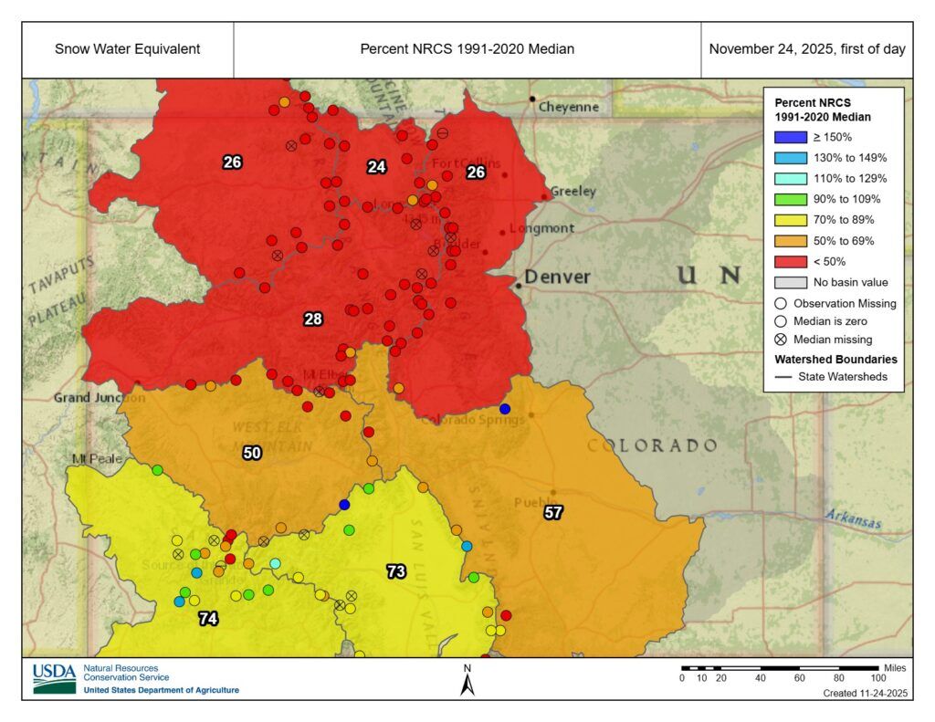
Also, the eight Colorado river basins are finally beginning to show signs of filling up with the five southern-most basins exceeding 50% of average. Compared to the start of the month when not one basin was above 20% of average.
Forecast:
Colorado is just south of a storm pushing through southern Montana and northern Wyoming on Monday, however, some light snow could fall in the northern mountains Monday night into Tuesday morning, with a trace-1 inch possible north of Interstate 70.
Snow is forecast to redevelop Tuesday night in the northern mountains and last into late night Wednesday or early Thursday morning (Thanksgiving Day).
Snowfall accumulations will be light with another 2-4 inches possible for the northern mountains for Thursday’s first chairs. The central and southern mountains should not see any accumulations.
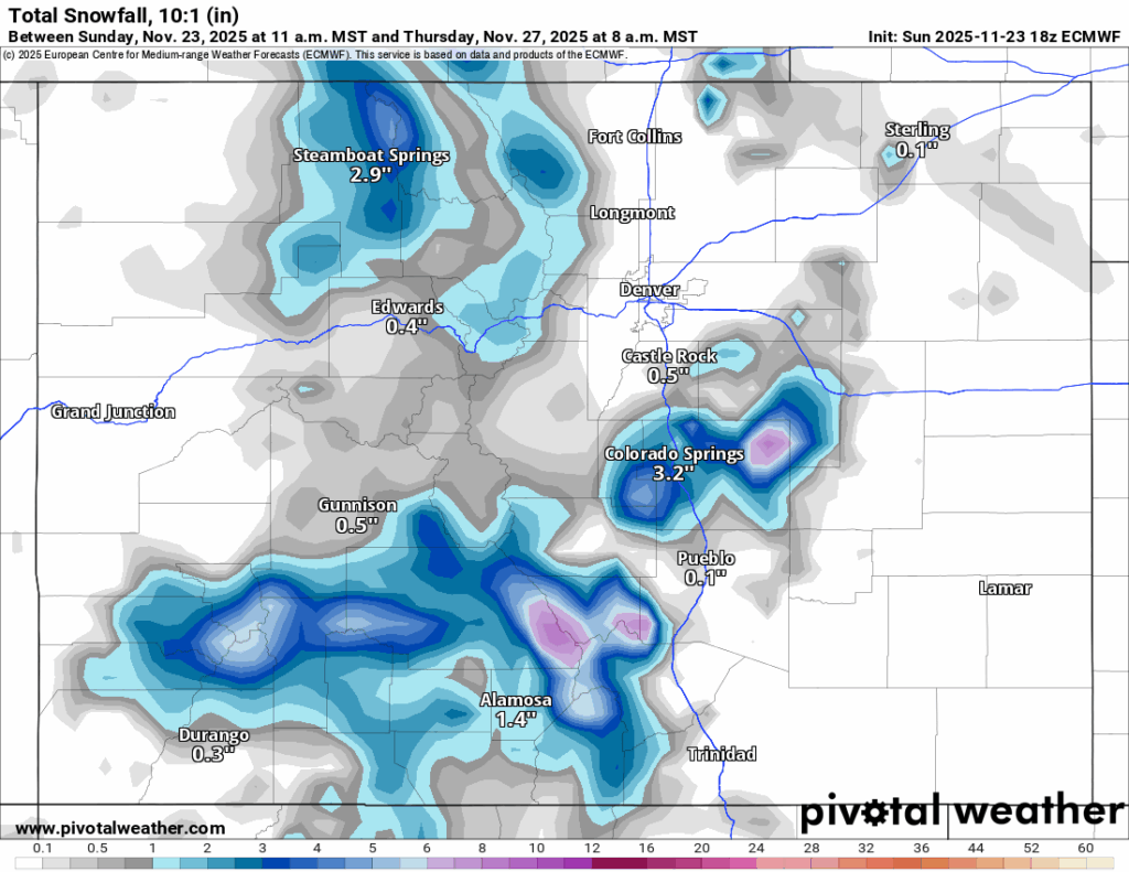
Friday is forecast to be calm and cool as the state is between storms. Highs are forecast to be in the mid 30s at most base areas and mid 20s at the summits.
Long-term forecast:
On Thursday, ahead of the Thanksgiving weekend, an area of low pressure is forecast to push ashore into the Pacific northwest.
By Saturday, this low pressure will have pushed south-southeastward, with snow developing in northern Colorado on Saturday night and spreading across the rest of the state Sunday morning.
Snow continues into Monday afternoon/evening, Dec. 1, with the southern mountains benefiting the most from this storm.
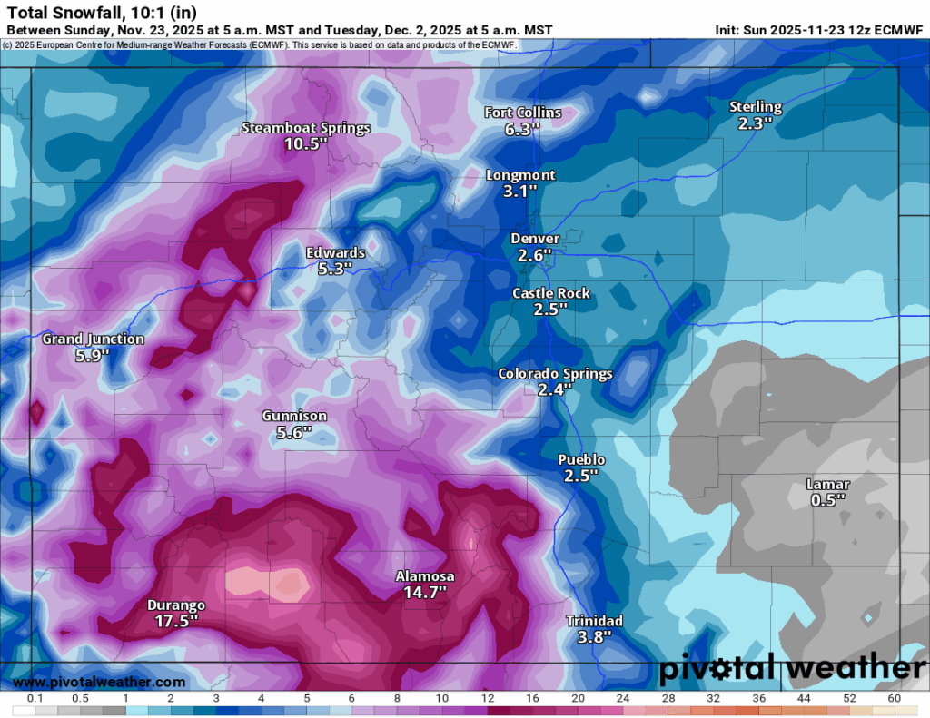
Possible snowfall totals in the southern mountains could be significant, with between 18-24 inches, in the central mountains between 8-16 inches with the highest amounts around the Grand Mesa and in the northern mountains between 6-12 inches with the highest amounts in the Park Range and Flattops in northwestern Colorado.
Colorado ski resorts’ planned opening dates and 24-hour totals:
Arapahoe Basin – 0″
Aspen Highlands – Dec. 13
Aspen Mountain – Nov. 27
Beaver Creek – Delayed
Breckenridge – 0″
Buttermilk – Dec. 13
Cooper – Dec. 10
Copper Mountain – 0″
Crested Butte – Nov. 26
Echo Mountain – TBD
Eldora Mountain – 0″
Granby Ranch – Nov. 26
Hesperus – Closed for the season
Howelsen Hill – Nov. 29
Kendall Mountain – December
Keystone – 0″
Loveland – 0″
Monarch – Delayed
Powderhorn – Delayed
Purgatory – Delayed
Silverton – Private mountain after Dec. 1, Guided and Heli season Dec. 27
Snowmass – Nov. 27
Steamboat – 0″
Sunlight – Dec. 12
Telluride – Nov. 27
Vail – 0″
Winter Park – 6″
Wolf Creek – 0″

Female aviators use Earheart’s legacy to inspire future pilots at Wings over the Rockies
Michael Braithwaite
michael.braithwaite@gazette.com
Updated 2 minutes ago
“Someone’s got to sit in that seat, why not me?” The line was written at the top of a poster board in the Wings Over the Rockies hanger at Centennial Airport Saturday morning. It also captured the essence of the...
Michael Braithwaite
Reporter

Can deliberation save democracy? | Vince Bzdek
vince-bzdek
vince.bzdek@gazette.com
Updated 54 minutes ago
In September 2019, 523 Americans traveled to Dallas, Texas, for an experiment called “America in One Room.” The gathering was designed to test a theory: Could representative citizens deliberate productively even in an era of intense polarization? The event took...
vince-bzdek
Reporter
Colorado health equity funder’s redirection debated
Debbie Kelley
debbie.kelley@gazette.com
Updated 20 hours ago
A redirection in grantmaking that began two years ago for The Colorado Trust, a 40-year-old Denver-headquartered funder, has led some employees to now voice concerns, which has reportedly put their jobs in jeopardy. The vice president of communications for the...
Debbie Kelley
Reporter
Redistricting scheme would give Colorado Democrats seven House members, split El Paso County
Bob Loevy
bob-loevy@denvergazette.com
Updated 8 hours ago
A proposed redistricting plan, which could give Colorado seven Democratic members of the U.S. House of Representatives and only one Republican, would split El Paso County into two parts and thereby weaken the county’s influence in Congress. El Paso County,...
Bob Loevy
Reporter
Battle of the Badges connects cops, community and cancer
John Moore
john.moore@denvergazette.com
Updated 5 hours ago
For Aurora and Denver first responders, the gloves come on for a good time and a good cause Guns down, gloves up. That was the mantra last Saturday night for the 30 Denver and Aurora police officers, firefighters, corrections officers...
John Moore
Reporter

Hopes and fears: Colorado Iranians speak out on widening war
Mark Samuelson
mark.samuelson@denvergazette.com
Updated 6 hours ago
Group talks about young people protesting against the Islamic Republic, and Reza Pahlavi and the monarchy When Denver area real estate agent Fara Novin dined out for her birthday Friday night, Feb. 27, she blew out a candle on a...
Mark Samuelson
Reporter

Truck driver hospitalized, United flight deplaned after Denver airport crash
Michael Braithwaite
michael.braithwaite@gazette.com
Updated 22 hours ago
The driver of a de-icing truck was hospitalized and a United Airlines flight was deplaned after a crash at Denver International Airport Friday morning. Amid heavy snowfall, United Airlines flight 605 headed to Nashville hit the truck while leaving the...
Michael Braithwaite
Reporter

Aurora police increase reward for 2024 cold fatal shooting case
Michael Braithwaite
michael.braithwaite@gazette.com
Updated 23 hours ago
The Aurora Police Department doubled the reward for information about a 2024 cold case fatal shooting to $4,000 Friday. The suspect in the shooting, which took place outside a convenience store in the 12000 block of East Colfax Avenue around...
Michael Braithwaite
Reporter
Another TABOR fight: Democrats plan to redirect residents’ refunds to K-12 spending
Marianne Goodland
marianne.goodland@coloradopolitics.com
Updated 3 hours ago
Colorado voters could decide this fall whether billions of dollars that would otherwise be returned as refunds under the Taxpayer’s Bill of Rights should instead go to public schools under a ballot measure unveiled Thursday by Democrats. Supporters say the...
Marianne Goodland
Reporter
Analysis: Colorado legislators introduce 18 energy bills amid debate over emissions goals
Scott Weiser
scott.weiser@gazette.com
Updated 24 hours ago
Colorado legislators have introduced 18 energy-related bills so far in the 2026 session, with Democrats sponsoring 14 and Republicans four, highlighting the sharp partisan split over how aggressively the state should pursue its greenhouse gas reduction goals while protecting affordability...
Scott Weiser
Reporter
PREV
PREVIOUS

Money Museum director in Colorado Springs helps make sense of the penny's demise
Abraham Lincoln was three years away from being elected president when the half-cent coin was discontinued as an official form of American currency. Now, his visage on the 1-cent coin is on track to join the lineage of obsolete coins throughout U.S. history. At one end of the basement floor of the Money Museum near […]

Denver weather: Mild conditions Monday starts dry Thanksgiving week, but snow is coming
Thanksgiving week starts off dry, calm and seasonal after cooler temperatures and some rain fell around metro Denver over the weekend; but still no snow. Denver residents can expect sunny skies, with a high near 57, according to the National Weather Service in Boulder. Light and variable winds become north between 5 to 10 mph […]