


Another round of 18 to 24″ of snow possible on Colorado mountain range
After a weekend of widespread snow in Colorado’s mountains, more snow is on the way. This round of wintery weather won’t be quite as widespread, but it should bring significant accumulation to a part of the state that’s already been hit hard in recent days.
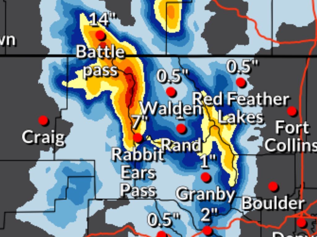
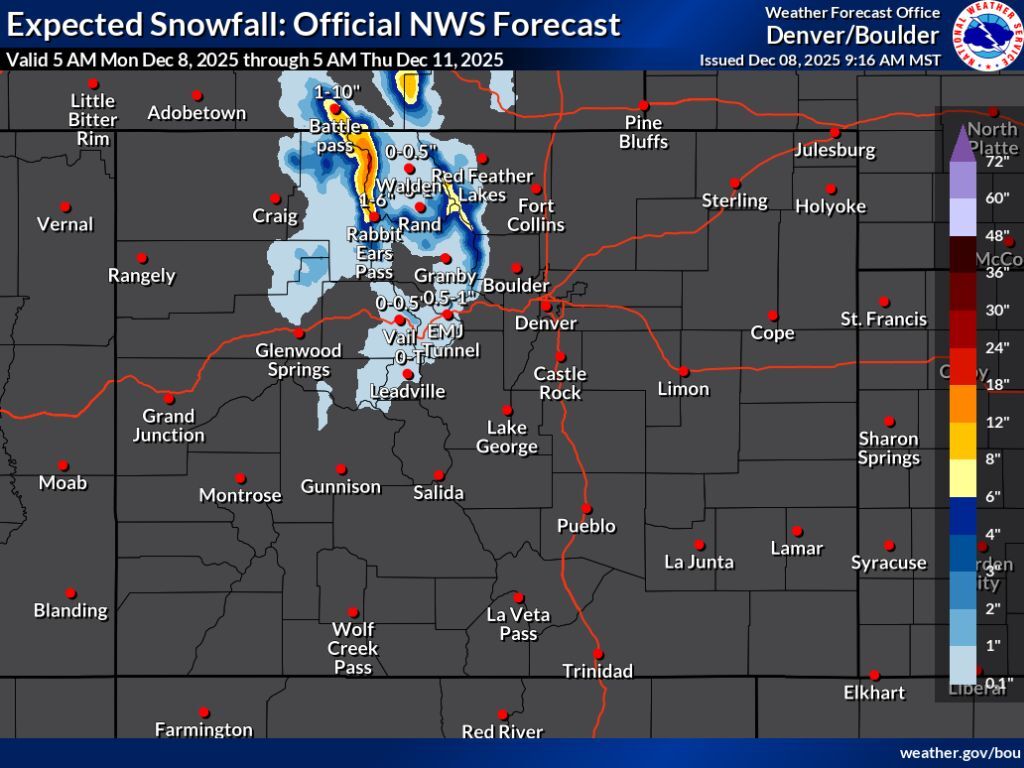
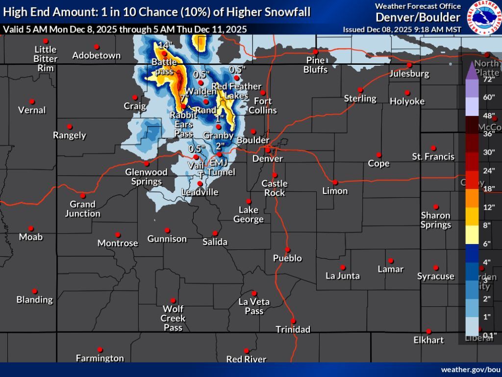
With this latest round of snow, most heavy accumulation will be limited to the Park Range of northwest Colorado, near Steamboat Springs. The current forecast depicts Tuesday and Wednesday as being the period in which most of this snow will fall.
Through Thursday morning, this area should get between 12 to 18 inches of snow on high-elevation peaks in the most likely ‘expected’ snowfall scenario (80% chance). These totals get upped to 18 to 24 inches if the ‘high-end’ snowfall scenario occurs (10% chance), with snowfall in this scenario being a bit more widespread, but still limited to northern Colorado. Even in the high-end scenario, I-70 still only gets about two to four inches during this stretch.
According to the Steamboat Resort mountain report, the ski area has gotten 17 inches of fresh snow over the last three days. This brings their total up to 34 inches on the season – and keep in mind that it was at about 13 inches prior to the storm that occurred on the tail-end of last week.
While the Park Range near Steamboat is expected to get hit pretty hard with this storm, the ski area might not benefit too much. According to OpenSnow, just four inches of snow are expected at the resort over the next five days.
The recent snow also helped with the snowpack in northwest Colorado in a big way. Last Friday, the area’s snowpack was at about 40 percent of the norm for the date. Today, snowpack is at about 75 percent of what’s typical for December 8.
The big widespread snow that fell on most Colorado mountains also helped to boost snowpack at the statewide level, too. Last Friday, statewide snowpack was at about 54 percent of the norm. Today, it’s at about 72 percent of what’s expected for the date.
See mapping of both snowfall forecast scenarios below:
Find additional weather and forecasting information on the National Weather Service website.
STAY INFORMED: Get free Colorado news with our daily newsletter (Click here)
Get OutThere
Signup today for free and be the first to get notified on new updates.
PREV
PREVIOUS

Rescue teams save individual stuck in Indian Creek
Douglas County Search and Rescue responded when an individual became stuck in Indian Creek on Thursday night. According to a Facebook post from DCSAR, they responded to a personal emergency beacon activation of an individual deep in Indian Creek who was ill and was not able to make it out themselves. DCSAR was able to […]
3 caught in 'surprise' avalanche that traveled 1,500 feet down mountainside in Colorado
As might be expected, avalanche risk around the state has increased after big snow in recent days. While that risk is subject to sudden change, at time of the publishing, mountains in northern Colorado are mostly at a risk level of 3 of 5 while those in the southern half of the state are at […]