


Trio of snow storms headed for Colorado, could deliver 10-20 inches by Christmas weekend
Snow is finally back in the forecast for Colorado as a trio of storms could bring snow to the state from the middle of this week through the Christmas weekend; maybe fresh snow on Christmas Day too.
Current forecast models show the possibility of between 10-20 inches of snow for the northern and central mountains over the next 10-12 days, with a bit lower totals in the southern mountains.
Good news for southern Colorado skiers and riders too.
Cuchara Mountain Park in Huerfano County could be spinning Chair 4 by New Year’s, the ski area announced Friday.
Cuchara said in a post online, “Panadero Ski Corporation says it is still working through a few minor maintenance items and tracking down some records from years past, but if all goes according to plan — and the weather gods cooperate — Cuchara Mountain Park’s Chair 4 will be open to the public by New Year’s.”
Recap:
Saturday and Sunday saw dry and warm (for December) conditions across the state. The high temperature at Copper Mountain on Saturday was 38 degrees and on Sunday was 44 degrees. The high temperature at Cascade near Purgatory on Saturday was 57 degrees and on Sunday was 52 degrees.
Forecast:
Monday and Tuesday are forecast to be dry and sunny across all three mountain zones.
During those days, a developing low pressure system in the Pacific Northwest will push eastward into Montana, dropping an arm of moisture southward into northern Colorado on Wednesday, bringing some snow showers with it.
Snow is forecast to last from Wednesday morning to Thursday morning.
Snowfall totals from Storm 1 in the northern mountains is forecast to be between 2-8 inches with the highest amounts in the Park Range around Steamboat.
In the central mountains, expected snowfall totals are between 2-8 inches with the highest amounts on the Grand Mesa and Flattops, and in the southern mountains between 1-2 inches with the northern San Juan Mountains receiving the snow.
Storm 2 arrives in two waves, Thursday night through Friday morning and Friday night through Saturday night, although the Thursday night storm should be limited in snowfall.
This storm favors the northern and central mountains similar to the first storm, with additional snow accumulations in the northern mountains of between 4-6 inches with the highest totals in the Park Range again, but the Front Range could see decent amounts.
For the central mountains, additional snowfall of between 2-4 inches is possible with the highest amounts in the Sawatch Mountains, and in the southern mountains between 1-2 inches with the northern San Juan Mountains benefiting once again.
Long-term forecast:
Sunday through Christmas Day Thursday, is forecasting toward being dry before Storm 3 arrives either late Christmas night or Friday, Dec. 26.
Current weather models have Storm 3 tracking northeastward across Colorado from the desert southwest, suggesting the southern mountains should benefit the most from this storm.
Assuming the weather models stay true, this storm will be mostly a mountains snow event, not an upslope event, bringing snow to all three mountain zones. The southwestern mountains would see snow late Thursday, Dec. 25 night/early Friday, Dec. 26 morning first before the storm spreads snow into the central and northern mountains on Friday through Saturday, Dec. 27.
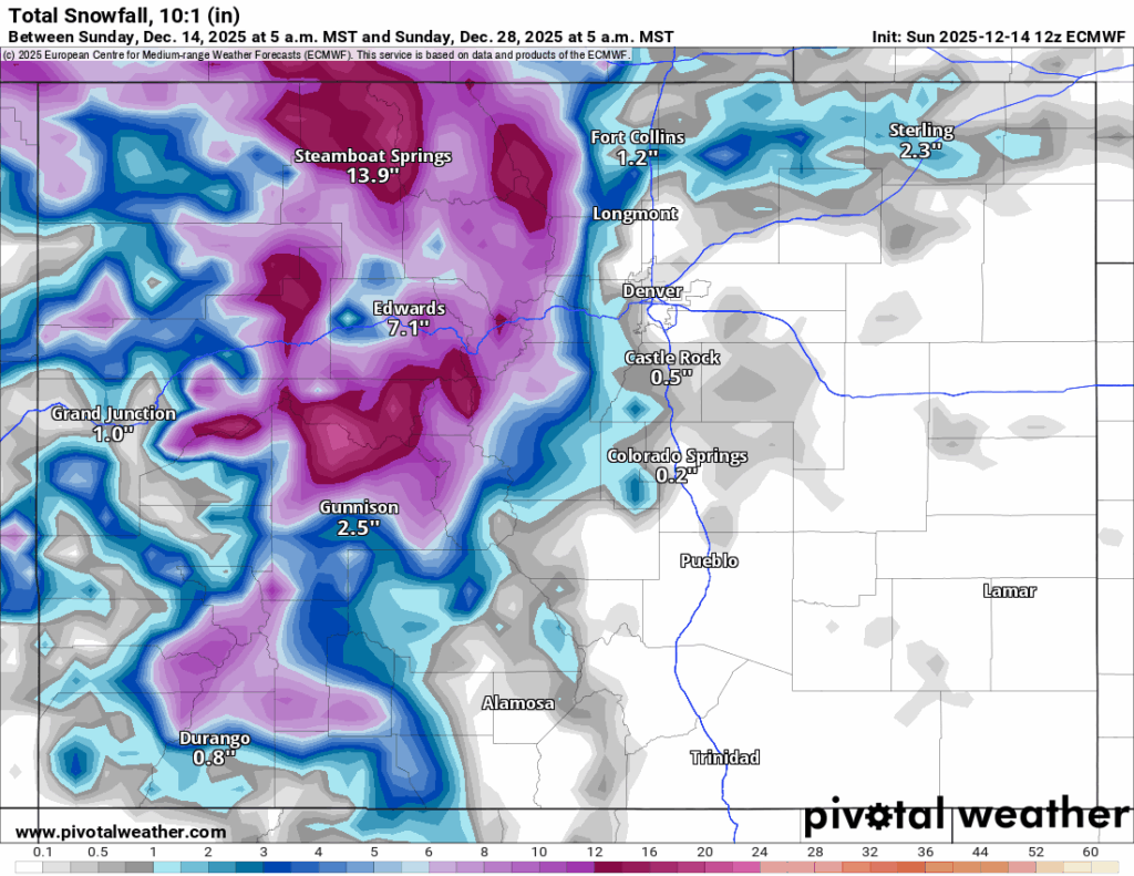
When all is said and done with these three storms, the northern mountains could receive between 10-20 inches, the central mountains between 10-20 inches and the southern mountains between 6-12 inches.
Colorado ski resorts 24-hour totals:
Arapahoe Basin – 0″
Aspen Highlands – 0″
Aspen Mountain – 0″
Beaver Creek – 0″
Breckenridge – 0″
Buttermilk – 0″
Cooper – 0″
Copper Mountain – 0″
Crested Butte – 0″
Cuchara – 0″
Echo Mountain – 0″
Eldora Mountain – 0″
Granby Ranch – 0″
Hesperus – Closed for the season
Howelsen Hill – 0″
Kendall Mountain – 0″
Keystone – 0″
Loveland – 0″
Monarch – 0″
Powderhorn – 0″
Purgatory – 0″
Silverton – Guided & Heli season Dec. 27
Snowmass – 0″
Steamboat – 0″
Sunlight – 0″
Telluride – 0″
Vail – 0″
Winter Park – 0″
Wolf Creek – 0″

State audit: Rape kit backlog reduced but more work needed to hit goal
Jenny Deam
jenny-deam@denvergazette.com
Updated 21 minutes ago
In the past year, the Colorado Bureau of Investigation has slashed the time it takes to process DNA collected in sexual assault cases, but the agency still is far short of its turnaround goal, the state auditor reported on Wednesday....
Jenny Deam
Reporter

Aurora officials look to Fort Worth in creation of police oversight office
Kyla Pearce
kyla-pearce@denvergazette.com
Updated 2 hours ago
As Aurora officials continue the process of creating a police oversight office, the police monitor of a Texas city similar to Aurora in size, demographics and structure told officials and residents Tuesday night that her office has built a strong...
Kyla Pearce
Reporter

Greeley voters halt landmark development project
Hap Fry, Special to The Gazette
hap-fry@gazette.com
Updated 2 hours ago
GREELEY – The landscape-altering Cascadia development project has been put on ice, according to unofficial results of a city referendum on the project Tuesday. The proposed Cascadia amenities included an 8,600-seat multiuse arena and ice center that would be the...
Hap Fry, Special to The Gazette
Reporter
Polis administration awards $7.2 million to cut emissions from large buildings
Scott Weiser
scott-weiser@denvergazette.com
Updated 3 hours ago
The Colorado Energy Office awarded $7.2 million Wednesday to help owners of large buildings across the state pursue high-impact projects that reduce greenhouse gas emissions through improved energy efficiency and electrification. The grants, drawn from federal Climate Pollution Reduction Grant...
Scott Weiser
Reporter

Denver Police arrest man, 20, in fatal Maple Avenue house party fight, shooting
Michael Braithwaite
michael.braithwaite@gazette.com
Updated 2 hours ago
Denver Police Department announced an arrest Tuesday in connection with a shooting a few weeks prior, during which one person was killed and another injured. Yeanbraiker Yriarte-Valera, 20, faces a first-degree murder charge after he allegedly shot and killed a...
Michael Braithwaite
Reporter
Report: Palantir exit could deal $178M blow to Colorado economy
Bernadette Berdychowski
bernadette.berdychowski@denvergazette.com
Updated 4 hours ago
Palantir Technologies’s decision to move its headquarters from Colorado to Florida is raising fresh concerns about the state’s business climate, with a new report warning the departure could shave hundreds of millions of dollars from Colorado’s economy and signal broader...
Bernadette Berdychowski
Reporter

Report: Palantir exit could deal $178M blow to Colorado economy
Bernadette Berdychowski
bernadette.berdychowski@denvergazette.com
Updated 17 minutes ago
Palantir Technologies’ decision to move its headquarters from Colorado to Florida is raising fresh worries about the state’s business climate, with a new report warning the departure could shave hundreds of millions of dollars from Colorado’s economy and signal broader...
Bernadette Berdychowski
Reporter

New Arvada Center CEO is Zoo’s Noelle DeLage
The Denver Gazette
the-denver-gazette@denvergazette.com
Updated 4 hours ago
The Arvada Center has named Noelle DeLage, chief communications and philanthropy officer of the Denver Zoo Conservation Alliance, as its next president & CEO. DeLage succeeds the retiring Philip Sneed effective July 1, just as the Arvada Center begins its...
The Denver Gazette
Reporter

House Ethics Committee dismisses some claims, advances others against Rep. Ron Weinberg
Marianne Goodland
marianne-goodland@denvergazette.com
Updated 3 hours ago
The House Ethics Committee voted on Wednesday to accept three allegations filed against Rep. Ron Weinberg, R-Loveland, but combined two into one subject area. The two issues involve inappropriate comments made to female lawmakers in two separate incidents and the...
Marianne Goodland
Reporter
Bipartisan opposition sinks eviction bill in Colorado
Marissa Ventrelli
marissa-ventrelli@denvergazette.com
Updated 21 minutes ago
Two Democrats sided with Republicans on a legislative panel to reject a proposal that would have made several changes to eviction filings and proceedings, including requiring judges to suppress court records. Sponsored by Rep. Junie Joseph, D-Boulder, House Bill 1047...
Marissa Ventrelli
Reporter
PREV
PREVIOUS

Denver area events for Dec. 15
If you have an event taking place in the Denver area, email information to carlotta.olson@gazette.com at least two weeks in advance. All events are listed in the calendar on space availability. Monday RiNo Arts District Food Tour — 1-4 p.m., Denver, $60 and up. Registration required: deliciousdenverfoodtours.com. My Favorite Queens — Presented by the Denver Gay Men’s […]

Denver weather: Record heat possible Monday as warm December continues
Denver just experienced six days straight of a high temperature of 60 degrees or above, and now can add Monday as day seven. The record high for Dec. 15 is 68 degrees. Denver residents can expect sunny skies today, with a high near 69, according to the National Weather Service in Boulder. South winds between […]