


Officials seek more ‘active management’ at sand dunes in northwest Colorado

At a scenic site of sand dunes in northwest Colorado, land managers want more “boots on the ground” through a new collaboration.
“Active management” was another phrase often repeated at a recent meeting in Walden, where officials with the Bureau of Land Management and Colorado Parks and Wildlife spoke to people who know and love North Sand Hills OHV Area, as the BLM has called it. The landowning agency has called it “Colorado’s only open sand dune area for OHV recreation.”
At the meeting to introduce new management, an agency representative alluded to “huge needs” regarding emergency response and law enforcement at the remote area: “That’s the biggest change we’re gonna see. We’re gonna have staffing out there we haven’t had in the past.”
That will be from CPW, which foresees a “Recreation Area as part of the Colorado State Park system,” a spokesperson previously told The Gazette in an email. Mentioned at the recent meeting was the Arkansas Headwaters Recreation Area, where CPW manages recreation and charges fees along a far-reaching stretch of river through federal land.
Bringing the model to North Sand Hills has long been in the works, said Doug Vilsack, the BLM’s Colorado director — “to kind of really address some of the camping opportunities that we have and the amazing recreation opportunities we have there,” he said. “How can we really build this place out and ensure we’re maintaining those opportunities, but at the same time maintaining safety?”
The BLM and CPW agreed to a memorandum of understanding last year, CPW’s deputy region manager said at the recent meeting. “It’s a MOU saying we’re gonna work together,” Jacob Brey said. “It’s early; it doesn’t dictate how things are gonna be done. That’s what this process is for, what your input is for.”
Feedback is being collected online through March 1, and another in-person and virtual meeting is anticipated during the summer.
Also this summer — when North Sand Hills seasonally opens to motorists — “you’ll start to see more of a presence between both agencies,” Brey said. He said surveying would continue to better understand the land encompassing nearly 2,500 acres in view of the Medicine Bow mountains, adjacent to State Forest State Park.
Along with safety concerns, “we also kind of see some resource damage and habitat degradation,” Brey said. “We want to try to curtail that before it gets out of hand.”
Surveying would determine “what’s been disturbed, what our (recreation) footprint is now and what it could be,” he said, adding interests to explore potential utility infrastructure and capacity.
“One of the things we’ve heard loud and clear is that there’s a lot of over capacity, and then there’s a lot of times where it’s under-utilized,” Brey said. “So it’s about finding that balance and how do we spread out that use.”

Vision Zero: As Denver doubles down, fatalities keep climbing
Mark Samuelson
mark-samuelson@denvergazette.com
Updated 6 hours ago
A decade ago, Denver became one of many U.S. cities to adopt a bold, new model of traffic safety — one that envisioned an end to the hundreds of serious injuries and dozens of fatalities that plague the streets each...
Mark Samuelson
Reporter
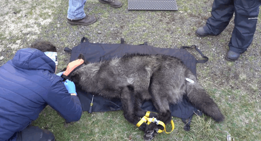
14th wolf dies in northwest Colorado
Marianne Goodland
marianne-goodland@denvergazette.com
Updated 7 hours ago
The 14th wolf to die in Colorado since their reintroduction about two years ago took place during a “collaring” operation in the northwestern region of the state last week. Colorado Parks and Wildlife said the wolf, identified as #2305 —...
Marianne Goodland
Reporter

Officials to discuss Colfax BRT, construction, business impacts at Aurora open house
Kyla Pearce
kyla-pearce@denvergazette.com
Updated 8 hours ago
Aurora and East Colfax Bus Rapid Transit officials will hold an open house for the public on Feb. 11 to talk about the transit project coming to the Colfax community. The open house is scheduled from 5:30 to 7:30 p.m....
Kyla Pearce
Reporter

More Denver residents could qualify for city property tax assistance
Deborah Grigsby
deborah.smith@denvergazette.com
Updated 7 hours ago
More Denver residents could qualify for the city’s property tax assistance program under a proposed change to the municipal code now making its way to the City Council. Members of the Community Planning and Housing Committee on Tuesday considered lowering...
Deborah Grigsby
Reporter

Jeffco had largest increase in homelessness in metro area last year
Sage Kelley
sage.kelley@denvergazette.com
Updated 7 hours ago
While Denver officials boasted a decrease in homelessness over the past few years, Jefferson County has seen the highest increase in the metro area. Jeffco saw a 27% increase in homelessness from 2024 to 2025 — the largest increase within...
Sage Kelley
Reporter

Colorado attorney general joins lawsuit against Trump energy emergency order
Scott Weiser
scott-weiser@denvergazette.com
Updated 6 hours ago
Colorado Attorney General Phil Weiser joined a multistate lawsuit challenging an executive order invoking the National Emergencies Act that President Donald Trump issued on the day of his inauguration. The order fast-tracks fossil fuel projects by bypassing or shortening environmental...
Scott Weiser
Reporter

Colorado’s federal judges slash motions backlog to lowest in years
Michael Karlik
michael-karlik@denvergazette.com
Updated 8 hours ago
Colorado’s federal trial judges collectively had 37 motions in civil cases that had been sitting on their dockets for at least six months without a ruling, as of Sept. 30. That is the smallest backlog the state’s U.S. District Court...
Michael Karlik
Reporter

Colorado delegation splits in House vote to end federal government shutdown
Ernest Luning
ernest-luning@denvergazette.com
Updated 7 hours ago
Colorado’s U.S. House members divided mostly along party lines Tuesday in separate votes on a funding deal to end the federal government’s partial shutdown, while giving Congress more time to negotiate long-term funding for the Department of Homeland Security. Lawmakers...
Ernest Luning
Reporter
Immigration resolution ignites hours of debate in Colorado House
Marissa Ventrelli
marissa-ventrelli@denvergazette.com
Updated 4 hours ago
A joint resolution affirming lawmakers’ “commitment to Coloradans navigating the complex United States immigration system” sparked more than three hours of debate on the House Floor on Tuesday morning, reflecting the tension rising between Colorado and the Trump administration, which...
Marissa Ventrelli
Reporter

Wife of former Cherry Creek superintendent placed on paid administrative leave
Nicole C. Brambila nico.brambila@denvergazette.com
nico.brambila@denvergazette.com
Updated 8 hours ago
Less than a week after Cherry Creek Schools Superintendent Chris Smith abruptly resigned following allegations of a toxic work environment, his wife, Brenda Smith, has been placed on paid, administrative leave, officials confirmed Tuesday. Brenda Smith is the district’s chief...
PREV
PREVIOUS

Denver weather: Chance of rain, snow Tuesday
Partly sunny skies will give way to a chance for afternoon rain and overnight snow in Denver on Tuesday, meteorologists predict. The National Weather Service in Boulder said to expect partly sunny skies with a high near 52 degrees in Denver on Tuesday. That’s about 7 degrees warmer than the average high for Feb. 3 […]

Lindsey Vonn 'confident' she can race at Olympics with ruptured ACL in left knee
CORTINA D’AMPEZZO, Italy (AP) — Lindsey Vonn is “confident” she can compete at the Milan Cortina Winter Olympics beginning this week with a torn ACL from a crash four days ago. Vonn said on Tuesday the damage to her left knee was a “completed ruptured” ACL, bone bruising “plus meniscal damage.” After three days of […]