


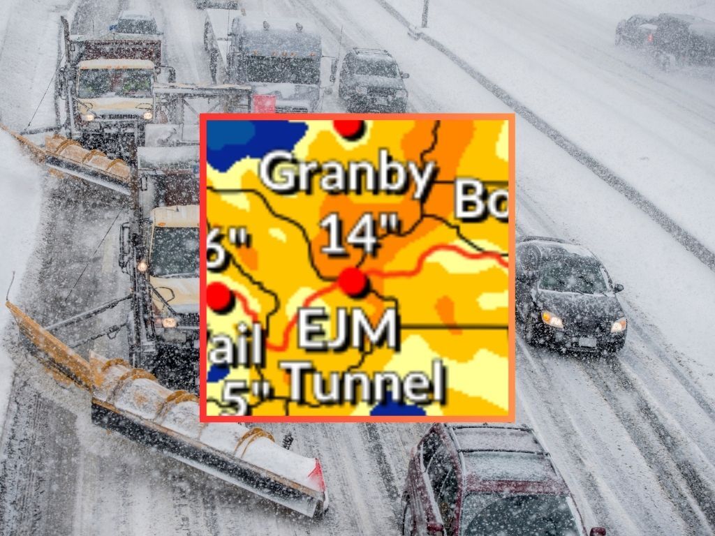
14″ of snow expected on key stretch of I-70 over next few days
Heads up Colorado travelers – big snow is expected over the next few days, and it may mean delays or an increased risk of vehicular crashes across much of the state’s mountainous terrain.
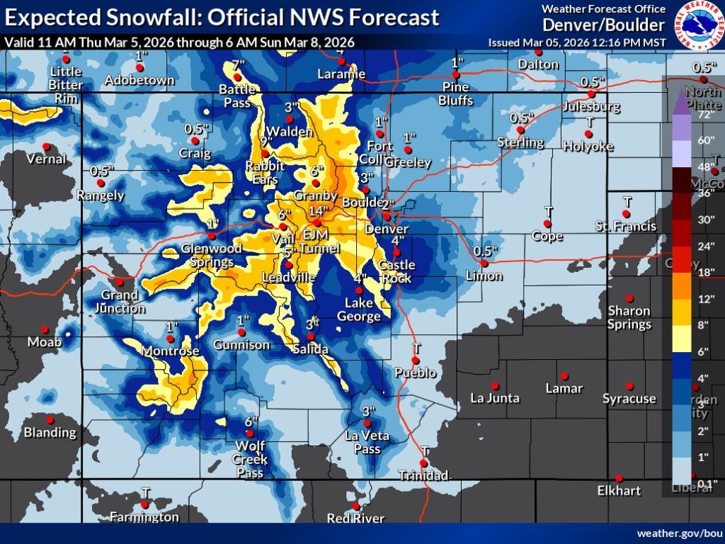
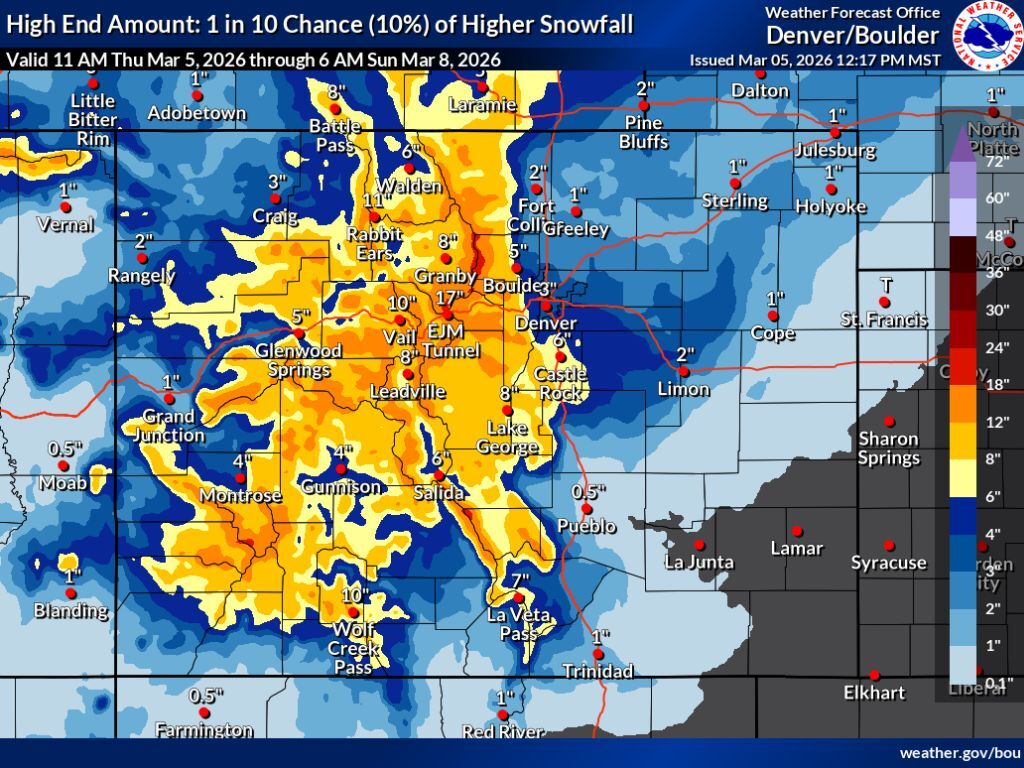
In the most likely snowfall scenario provided by the National Weather Service (80% chance), the area of the highly-trafficked Eisenhower-Johnson Memorial Tunnel Complex along I-70 gets about 14 inches of snow between 11 a.m. on Thursday and 6 a.m. on Sunday. Much of this snow should fall on Friday. In the less-likely, but more impactful ‘high-end’ snowfall scenario (10% chance), snow accumulation along this stretch of highway jumps to 17 inches.
Meanwhile, most of Colorado’s mountains will likely get between six and 12 inches of snow during this period in the most likely scenario, with snow in the 12 to 18-inch range possible along the Continental Divide north of I-70. The ‘high-end’ scenario shows that totals of this nature could be much more widespread, with some of the heaviest hit mountains getting snow in the range of 18 to 24 inches, as well.
Per the latest OpenSnow report, many of Colorado’s ski areas are looking at 10 or more inches of snow over the next five days. All major ski areas should get at least some snow (see a resort-specific breakdown here).
National Weather Service mapping related to both the ‘expected’ snowfall scenario (80% chance) and the ‘high-end’ snowfall scenario (10% chance) can be found below:
As of March 5, the statewide snowpack is at 61 percent of the norm for the date – 8.1 inches of snow-water equivalent and record low for this point in the season. The previous record low for March 5 was 8.4 inches and the norm is 13.2.
Find additional forecasting information on the National Weather Service website.
STAY INFORMED: Get free Colorado news with our daily newsletter (Click here)
Get OutThere
Signup today for free and be the first to get notified on new updates.
PREV
PREVIOUS

28-foot-long, 8,000-pound potato making its way through Colorado on national tour
You’ve heard about Oscar Meyer’s Wienermobile, but have you heard about the massive Idaho potato truck? It’s in Colorado at last report, towing a potato that weighs 8,000 pounds. Part of ‘The Famous Idaho Potato Tour,’ which has taken place more than a dozen times, the truck aims to pass through all 50 states and […]
Colorado's first 'glass-floored' gondola makes debut 1,200 feet above canyon floor
Colorado’s first ‘clear-floor’ gondola is open for business – but you won’t find it at a ski resort. Suspended about 1,200 feet above the canyon floor, the clear floors of the Royal Gorge Bridge and Park gondola are designed to give riders an unmatched panoramic viewing experience. As of February 28, two gondola carriages now […]