


Baseball-size hail a risk with Colorado’s urban I-25 under threat
Colorado isn’t necessarily known for severe storms happening overnight, but according to the National Weather Service, many of the state’s residents should plan for that to be the case. After damaging hail moved through parts of the urban I-25 corridor and Eastern Plains region on Tuesday, more baseball-size hail, damaging winds, and tornados are possible across a large heavily-populated swath of the state.
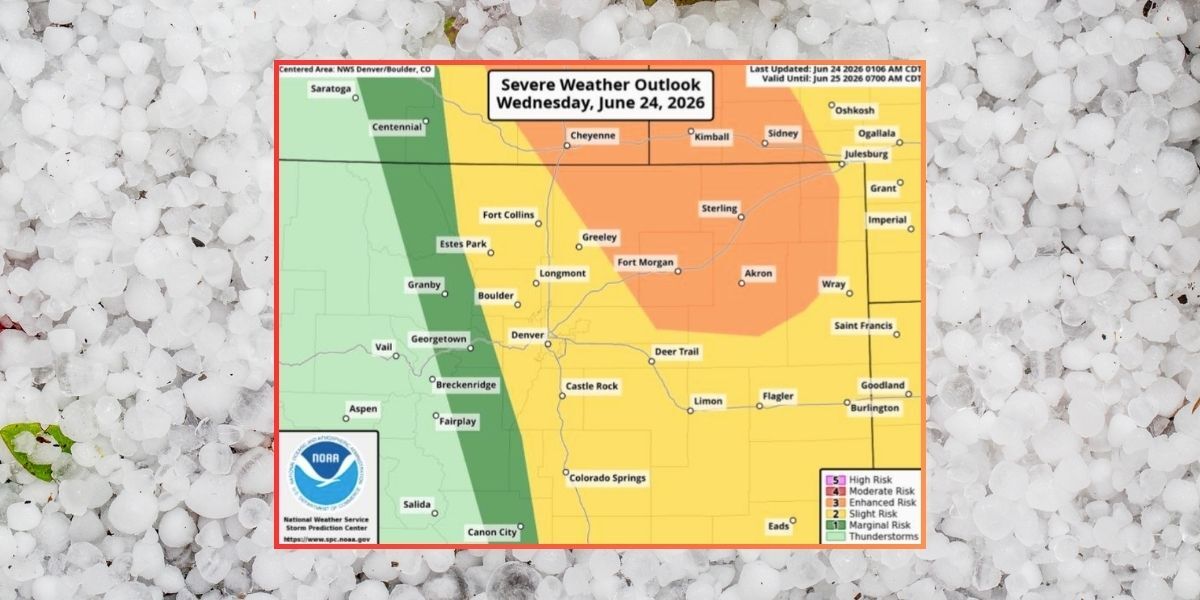
According to the National Weather Service, the timing of multiple possible storms is expected to range from 7 p.m. on Wednesday through 4 a.m. on Thursday with the strongest storms likely to appear in the evening. “Very large hail [is] possible,” says the National Weather Service, with the threat including the urban corridor.
Mapping from the National Weather Service depicts risk at five levels with five being the highest. The portion of the state at level three risk includes cities of Fort Morgan, Sterling, and Akron, with all of the I-25 corridor, including Denver, Fort Collins, Colorado Springs, and Boulder, at level two. Risk is lower in the mountains, though some Front Range spots like Estes Park are considered level two, as well.
While baseball-size hail is one risk, winds could hit speeds of up to 70 miles per hour. Additionally, the tornado threat is rated at low-medium. Damage to trees, homes, and vehicles will be possible.
Those with access to a garage in threatened areas should park inside overnight. Mapping of the risk zones can be found below:


Find additional forecasting information on the National Weather Service website. If you’re looking for a radar that shows what could occur a few hours out, The Weather Channel has a good one.
STAY INFORMED: Get free Colorado news with our daily newsletter (Click here)
Get OutThere
Signup today for free and be the first to get notified on new updates.
PREV
PREVIOUS
Colorado's most beautiful drive?
We stumbled on perhaps the most beautiful drive in Colorado by accident on Saturday. “Do you want to take the highway?” I asked my wife and our son after a day of fruitless fly fishing in the famous Dream Stream. It had been a beautiful day of hiking along the South Platte River that connects […]

Man crushed to death by half-ton boulder while on trail in Colorado
A tragic situation unfolded on June 23 in Chaffee County, Colorado, when a man was killed by a boulder that dislodged along a trail. According to a report from the sheriff’s office, two men employed by a moving company stopped at the Rapid 5 1/2 pullover after completing a job for a quick walk along […]