A German company detects wildfires from space. It made Denver its U.S. hub.
OroraTech is expanding its thermal data satellite business into the U.S., beginning with Denver.
There’s a new satellite company in town that specializes in spotting and tracking potential wildfires from space.
Just in time for Colorado’s peak wildfire season.
OroraTech, a Germany-based aerospace company founded in 2018, opened its new U.S. headquarters in downtown Denver this week.
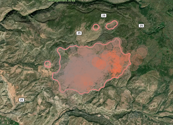
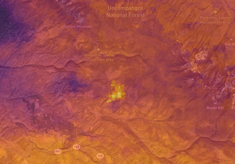
It has the largest constellation of satellites devoted to wildfires, according to the company. It operates 10 satellites with special thermal data imaging and taps into a network of public satellites, totaling more than 40 satellites in low-Earth orbit.
The satellites can detect heat anomalies and use predictive modeling to gauge the severity of potential threats.
OroraTech’s Denver hub will act as an operating center to connect with clients such as federal emergency services, utility providers and government agencies.
“Wildfires are one of the most devastating natural disasters facing the United States today, with the 2025 L.A. fires costing about $135 billion in damages alone,” said Thomas Gruebler, co-founder of OroraTech, in a news release. “We are deeply committed to introducing American firefighters and emergency responders to our satellite technology that will give them a new layer of situational awareness to make faster, smarter decisions when every minute counts.”
Satellite technology can have a lag in response to active emergency situations, said Jay Stalnacker, OroraTech’s vice president of strategy in the U.S. Many satellites with wildfire detection capabilities are built for multiple missions such as weather tracking, meaning there’s more data to sift through.
“We get satellite data days after the fire incident or days into it and so we really couldn’t rely on it and it wasn’t very useful” Stalnacker said.
OroraTech’s satellites are specifically built for wildfires and can provide real-time analysis for emergency services to respond to, he said.
Stalnacker was a former smokejumper for the U.S. Forest Service and fire management officer for Boulder County, before joining Ororatech.
“After being in the field for so long and seeing no innovation growth in technology in wildfire management, it was refreshing to see some new ideas,” he said.
The company was considering establishing its HQ in California but chose Colorado instead, Stalnacker said, citing the state’s wildfire management programs and the large aerospace industry clustered around the Front Range.
The state also has more central access to other Western states impacted by wildfires such as Montana, Wyoming and Idaho.
The company already landed a contract with Larimer County as one of the first U.S. customers for its Wildfire Solution Coop program.
“Proactive preparation is the key to reducing wildfire risk and protecting our communities,” said Justin Whitesell, emergency services director for the Larimer County Sheriff’s Office, in a press release. “However, tools for wildfire intelligence and situational awareness are still critical”
“The synergy between OroraTech’s cutting-edge technology and the Larimer County Sheriff’s Office of Emergency Services’ local initiatives exemplifies a comprehensive approach to wildfire resilience, setting a precedent for other regions facing similar challenges,” he added.
The company also signed a €20 million deal with Greece last year to monitor the entire European nation for potential wildfires.
The technology is not only able to detect a fire, but also what kind of fire it is to help first responders provide a more adequate response at the scene more effectively.
Using predictive A.I., it measures drought and wind conditions to determine how much fuel the fire has to spread.
Firefighters responding to a call can know what they’re walking into instead of going to the scene to determine the scope of the fire and calling for backup if needed, which is time lost in stopping a wildfire from going out of control.
It could also mean getting heavy air tankers and helicopters — which can take hours to arrive — sooner into the field.
“We have this thing in wildfire management called the decision-versus-time paradox. You have to make a decision and you don’t have a lot of time to make it,” Stalnacker said. “What we’re doing is adding more time to the clock and that’s invaluable.”