




Up to three inches of rain expected to fall within two hours in Colorado
Those on Colorado’s Front Range should be ready for some serious weather that could roll through on Thursday and Friday.
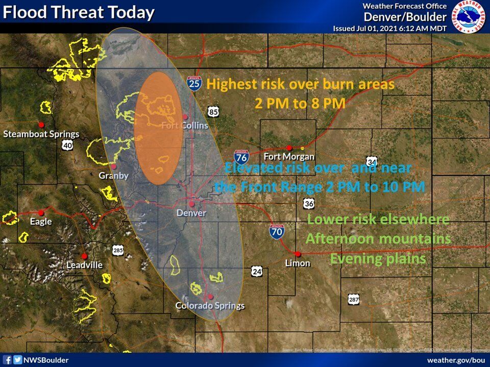
The National Weather Service is calling for severe slow-moving thunderstorms to bring monsoon rains, issuing a flood watch from Colorado’s northern border to its southern border. The flood watch runs along the I-25 corridor, stretching out to the east and west, impacting a number of cities and towns, including Fort Collins, Boulder, Denver, Castle Rock, Colorado Springs, Cañon City, Pueblo, Westcliffe, and Trinidad.
According to a ‘hazardous weather outlook‘ for the northern half of the I-25 corridor, storms in this area are expected to produce one to three inches of rainfall in a one to two-hour span. The biggest Thursday threat in this part of the state is along the eastern slopes of the Front Range between 2 PM and 8 PM, especially at higher elevations. During this time, heavy rainfall will likely hit fresh burn scars, including in the Grand County and Boulder areas, resulting in a serious risk of flash flooding.
Those located on the southern portion of I-25 should watch out for heavy rainfall on Thursday afternoon and evening, in addition to other hazards. Wind in this part of the state is expected to reach up to 60 miles per hour as storms roll through, producing hail the side of quarters. Lightning is also expected.
Thunderstorms are also predicted to hit on Friday afternoon and evening with locally heavy rainfall possible due to how slow the storms are expected to move.
Weather should calm down around much of Colorado by the time the weekend hits.
Find more weather updates on the official National Weather Service website.

Get OutThere
Signup today for free and be the first to get notified on new updates.
PREV
PREVIOUS
Flash flood watch issued for I-25 corridor, Front Range
The National Weather Service Thursday morning issued a flash flood watch for El Paso, Teller and Pueblo counties and much of the Interstate 25 corridor. Forecasters issued the watch to heighten awareness about an elevated risk for floods due to “slow-moving thunderstorms with heavy rain that could potentially lead to flash flooding along part of the I-25 corridor,” said Stephen Rodriguez, a National Weather Service […]

Public urged to avoid 'skin-to-water' contact at Colorado reservoir
Colorado Parks and Wildlife is alerting the public about a blue-green algae bloom that could be potentially dangerous if touched or ingested at DeWeese Reservoir in northern Custer County. According to a press release, officials are concerned about the increased levels of toxicity found on Wednesday in tests of the reservoir water after elevated levels of […]