


Mountain pass could get 30 inches of snow this weekend, 15″ expected on I-70

With big snow on the way this weekend and Colorado’s central and northern mountain regions set to get double-digit accumulation through Sunday (and one range having the potential for four-plus feet), the National Weather Service has released a series of its more interesting winter weather-related images. The images depict how much snow is expected on various high-traffic roads around the state, providing some easy-to-digest insight on what travelers can expect.
The most problematic roadway of the weekend is likely to be a toss-up between US 40 over Rabbit Ears Pass and the mountainous stretch of I-70. Rabbit Ears Pass could get up to 30 inches of snow from Friday night through Sunday, thus the sheer amount of fresh powder could cause issues. Meanwhile, parts of I-70 – specifically the Eisenhower-Johnson Tunnel Complex area and Vail Pass – should get up to 15 inches of snow. It doesn’t take much to result in delays on this stretch of road. It’s also worth noting that while Berthoud and Loveland passes weren’t among the spots the National Weather Service highlights, these roads are in the same general area and should also get their fair share of snow.
Check out a few of the maps below:
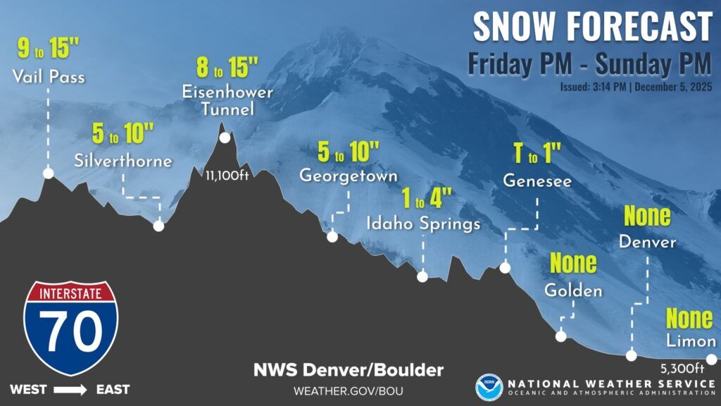

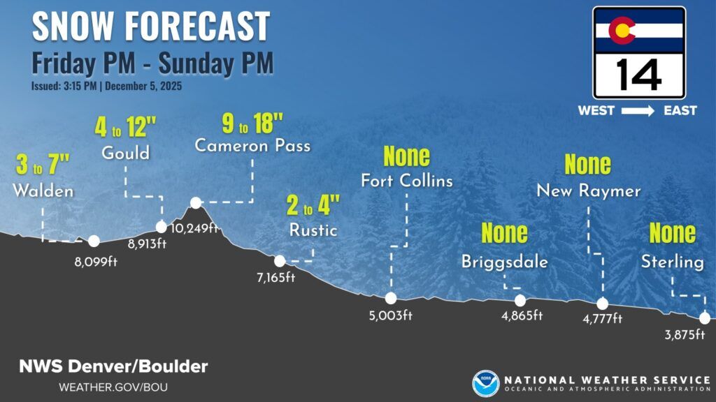
While those on the Front Range shouldn’t expect much (if any) snow along I-25, most mountain travel could get dicey. The National Weather Service is warning the public that travel could be “very difficult to impossible.”
If you’re planning on visiting the mountains, plan ahead by packing these 27 survival items. Follow along with updates on road conditions on the Colorado Department of Transportation CoTrip map.
STAY INFORMED: Sign-up for the daily OutThere Colorado newsletter here
Get OutThere
Signup today for free and be the first to get notified on new updates.
PREV
PREVIOUS

The 'friendliest' neighborhood in Denver is also one of metro's 'most affordable'
When it comes to picking a place to call home, what more can you ask for than friendliness and affordability? According to Nextdoor, a certain Denver metro neighborhood offers both of those attributes, known for its peaceful and family-friendly atmosphere, clean parks, and diverse community feel. Nextdoor’s ranking of the 20 ‘friendliest’ neighborhoods in the […]

Colorado resort ranks among the 'most legendary' on Earth
Forbes’ inaugural Hotel Icons List includes lots of luxurious European lodging, with the Waldorf Astoria Amsterdam, Ritz Paris, and the Savoy in London. Only five U.S. hotels made the list, with four of those five being in the East Coast. The last U.S. establishment that made the list is located in Colorado. The Broadmoor is […]