


Up to 12 inches of snow could hit peaks on Friday – but more is likely on the way
The first of three waves of snow expected to hit Colorado through the end of April should land on Friday, and while more significant snow could be on the way, some specific areas could get snow in the range of eight to 12 inches as this initial round lands.
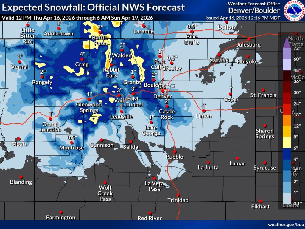
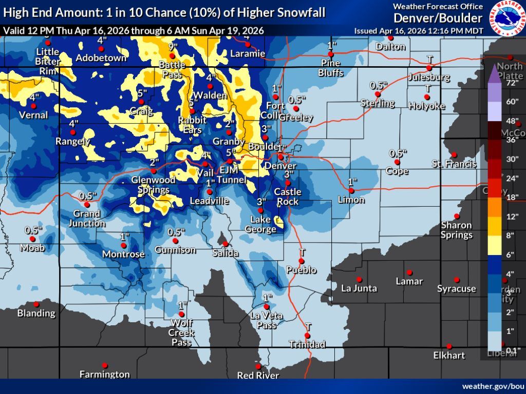
Earlier today, the National Weather Service released their snowfall forecast for April 16 through the morning of April 19 – but keep in mind, while this period spans several days, the vast majority of that snow should hit on Friday, April 17.
In general, incoming storm should favor northern Colorado, with limited pockets of deeper totals accumulating on peaks south of I-70. The hardest hit areas should be the northern Front Range and the Park Range near Steamboat Springs, with these spots having potential for about six to eight inches of snow in the most likely scenario. Meanwhile, much of northern Colorado gets about three to six inches.
In the high-end scenario (10% chance), deeper totals are more widespread, but still not above eight to 12 inches of snow. Totals in that range will be mostly restricted to higher-elevation areas, though it doesn’t take much to drastically impact travel over mountain passes and along mountain highways (as was seen this week when a 70-vehicle pile-up occurred on I-70).
Totals along the I-25 corridor are limited in both scenarios, though relatively widespread flurries are expected. Places like Boulder and Castle Rock could end up with snow in the two to three-inch range.
See mapping of both snowfall scenarios (the ‘expected’ scenario with an 80% chance and the ‘high-end’ scenario with a 10% chance) below:
It’s worth noting that while impacts should be relatively limited in this storm, Colorado is featured on the National Weather Service’s ‘risk of heavy snow’ map for several upcoming days next week. Read more about that here.
As of April 16, the statewide snowpack is at 20 percent of the norm for the date – typical of what’s seen around May 31 on the normal season.
Find additional forecasting on the National Weather Service website.
STAY INFORMED: Get free Colorado news with our daily newsletter (Click here)
Get OutThere
Signup today for free and be the first to get notified on new updates.
PREV
PREVIOUS

The argument for 'pay-to-play' in outdoor recreation (and 5 key concerns that come with it)
Don’t hate me – I’m fully aware that most outdoor recreation enthusiasts would prefer that all access is free. Gear is already expensive, so is the gas to get to the trailhead and with all of the positive benefits that outdoor recreation can bring to life, it’s worth the effort to make sure that these […]

NWS 'risk of heavy snow' map includes large swath of Colorado next week
As you may have heard, three more rounds of snow are expected to hit Colorado through the month’s end. While one of those waves is expected to land on Friday, another, more significant round of snow could soon follow. Per the National Weather Service ‘Risk of Heavy Snow’ map that’s produced by the agency’s Climate […]