


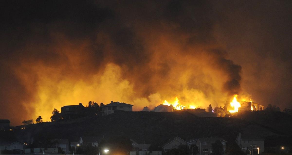
Fight over wildfire evacuation planning heads to the Colorado Springs City Council
Jerilee Bennett, Gazette file
A long-simmering fight over wildfire evacuation planning is headed to the Colorado Springs City Council Tuesday for a vote on a possible new ordinance that residents say falls short of what is needed.
The city staff’s proposed ordinance would require breaking the city up into evacuation zones based on topography, the road network and other factors. City fire officials have said smaller evacuation zones could be easier to evacuate. It also calls for an education campaign for residents to know their zone, if a wildfire or another disaster prompted an evacuation. The evacuation plan would be updated every five years under the proposed rule.
Council President Tom Strand said the seven other board members that could be reached were interested in the staff-developed proposal that was presented to them informally in May. He said he was interested in hearing again from city staff and residents.
“I am anxious to hear what it’s in the best interest of the city from all parties that are involved,” he said.
Advocates say the draft ordinance does not include any of the specifics they asked for in November following presentations by evacuation experts. As part of that meeting, councilmembers heard about the long-evacuation times residents would face trying to flee a wildfire in the Broadmoor neighborhood and other areas west of Interstate 25.
Bill Wysong with Westside Watch, a Colorado Springs wildfire safety advocacy group, said the ordinance seems to be a political move ahead of the coming mayoral and City Council elections in April.
“It doesn’t warrant the time and effort that the city has spent on it,” Wysong said. The city does not need an ordinance to purchase the ZoneHaven system that would help city officials evacuate the community in smaller zones, he said.
Residents asked the city to model how long it could take to leave neighborhoods and designate evacuation routes for hazards coming from all four directions. The proposed ordinance would require the city to post evacuation times and routes online. It would also require the city to evaluate how new developments could increase evacuation times and require that longer times be addressed through design changes or added roads.
“People need to know how long is it going to take you to get out,” said Dana Duggan, a founder of Westside Watch. Residents and visitors also need maps with safe zones where they could shelter identified, because it’s easy to get disoriented in the chaos of a fire.
Evacuation modeling presented by Old Dominion University Professor Mike Robinson, to the City Council in November showed evacuating the Broadmoor area during the summer with visitors at The Broadmoor resort, Cheyenne Mountain Zoo and Seven Falls could take about five hours. The Fast Local Emergency Evacuation Times system Robinson helped develop to model evacuations is available for free to cities and others to plan for emergencies.
Robinson was hired by Pacific, Gas & Electric Co. to assess evacuation plans in California following the 2018 Camp fire in Paradise that killed about 85 people.
A Los Angeles Times investigation of the Camp fire showed the community was split into zones for evacuation purposes to help prevent traffic congestion. But most of the city’s zones never received an order to leave because the “loss of fiber-optic lines and cell towers shut down the warning system completely.” The community also never used evacuation modeling to determine how long it could take for the whole community to leave, the investigation showed.
Westside Watch advocates have said they believe a fast-moving fire could move through the Broadmoor area because, in 1950, a wind-driven fire that started in what is now the Broadmoor Golf Course destroyed 92 buildings and killed nine people.
Strand said he is concerned the evacuation ordinance proposed by the neighborhood could negatively impact development.
“We don’t want it to negatively impact the growth of the city,” he said.
Colorado Springs fire officials have said in the past residents can model their own evacuation times and be aware of the risk in their own neighborhoods.
Wysong said his group is not anti-development, but that new residences and growth should be thoughtfully considered. There is a clear difference between a few new single-family homes and hundreds of new apartments on critical egress routes, he said.
At the same time, state legislatures are also taking a closer look at evacuation modeling.
California adopted a new law that requires all communities to “identify evacuation routes and their capacity, safety, and viability under a range of emergency scenarios.”
The Colorado Legislature’s Wildfire Matters Review Committee that meets during the summer could also explore potential of evacuation modeling and how it could help communities understand their risks, said Rep. Marc Snyder, D-Colorado Springs, a committee member. He noted the Marshall fire that destroyed more than 1,000 homes and could not be fought from planes was a game changer.
“We want to protect people and property,” he said.
Contact the writer at mary.shinn@gazette.com or 719-429-9264.

Audit finds major gaps in Colorado’s oil and gas reporting, enforcement
Marissa Ventrelli
marissa-ventrelli@denvergazette.com
Updated 50 minutes ago
The agencies responsible for regulating Colorado’s oil and gas industry are underperforming when it comes to reporting and enforcement, according to a recent performance audit by the Office of the State Auditor. The OSA audit reviewed 2023 data on oil...
Marissa Ventrelli
Reporter

Aurora woman hit, killed while crossing street
Kyla Pearce
kyla-pearce@denvergazette.com
Updated 2 hours ago
An Aurora woman was killed Sunday after being hit by a truck while crossing the street, according to an Aurora Police Department news release Monday morning. Officers responded to the crash, at the intersection of South Oak Hill Way and...
Kyla Pearce
Reporter

Trump says Zelenskyy ‘hasn’t read’ a US-authored proposal to end Russia-Ukraine war
Susie Blann
susie.blann@associatedpress.com
Updated 3 hours ago
KYIV, Ukraine (AP) — President Donald Trump on Sunday claimed Ukrainian President Volodymyr Zelenskyy “hasn’t read” a U.S-authored peace proposal aimed at ending the Russia-Ukraine war. Trump was critical of Zelenskyy after U.S. and Ukrainian negotiators completed three days of...
Susie Blann
Reporter
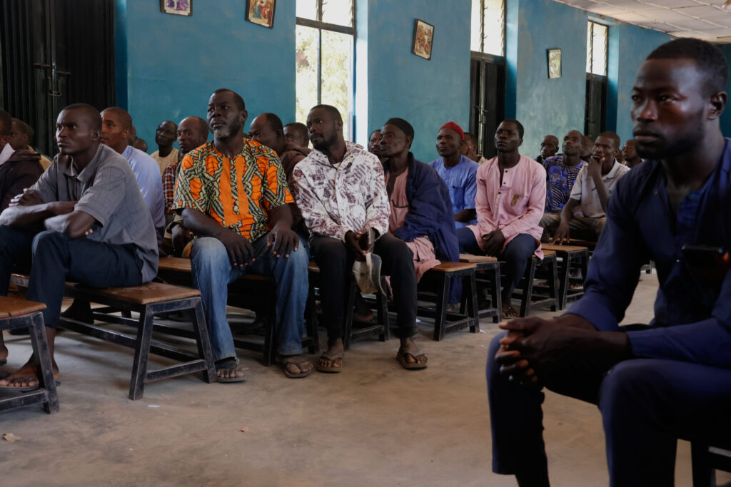
100 schoolchildren abducted in Nigeria are released but more are still held
Associated Press
associated-press@denvergazette.com
Updated 3 hours ago
MINNA, Nigeria (AP) — A total of 100 of the schoolchildren abducted from a Nigerian Catholic school last month have been released, the Christian Association of Nigeria said Monday, adding that more than 100 students remain in captivity. At least...
Associated Press
Reporter

Trump to announce $12 billion farm aid program
Washington Examiner Staff, Washington Examiner
washington.examiner.staff.washington.examiner@gazetteedit.wpenginepowered.com
Updated 3 hours ago
President Donald Trump is expected to announce a $12 billion farm aid program on Monday. The plan to provide aid to the nation’s farming industry comes as many have endured financial hardship due to low crop prices, the fallout associated...

Colorado Gives Foundation turns 50 during giving season
Kyla Pearce
kyla-pearce@denvergazette.com
Updated 4 hours ago
Colorado Gives Day is Tuesday. The Colorado Gives Foundation, which started as a small hospital fundraising group and has grown into a statewide nonprofit, is celebrating its 50th anniversary shortly after Giving Tuesday. Colorado Gives Day, which was created by...
Kyla Pearce
Reporter

Colorado Democrat Julie Gonzales launches US Senate primary challenge to incumbent John Hickenlooper
Ernest Luning
ernest-luning@denvergazette.com
Updated 2 hours ago
Declaring that Colorado “needs a fighter, not a bystander,” state Sen. Julie Gonzales, a Denver Democrat, on Monday launched her long-anticipated primary challenge to U.S. Sen. John Hickenlooper. Pitching her campaign as a departure from “old-playbook politics,” Gonzales said she’s...
Ernest Luning
Reporter

Large weekend storm drops 33″ of snow at one Colorado spot, snowpack doubles over 7 day stretch
Jonathan Ingraham
jonathan.ingraham@denvergazette.com
Updated 6 hours ago
The first big snow storm of winter 2025-26 for Colorado dropped about 10-20 inches in the northern mountains, 8-14 inches in the central mountains and 3-8 inches in the southern mountains. Colorado’s snowpack doubled in both median average and snow...
Jonathan Ingraham
Reporter
Denver weather: More melting on Monday as temperatures climb
Jonathan Ingraham
jonathan.ingraham@denvergazette.com
Updated 7 hours ago
Melting snow will continue Monday across metro Denver as the sun is forecast to come out in full as temperatures push into the 50s today. Denverites can expect sunny skies, with a high near 53 today, according to the National...
Jonathan Ingraham
Reporter

Democrat Shannon Bird to step down from Colorado legislature to campaign full-time for Congress
Ernest Luning
ernest-luning@denvergazette.com
Updated 4 hours ago
State Rep. Shannon Bird, a Westminster Democrat, said Sunday that she plans to resign from the Colorado legislature next month in order to focus on running for the 8th Congressional District seat held by Republican U.S. Rep. Gabe Evans. Bird...
Ernest Luning
Reporter
PREV
PREVIOUS
22-year-old Colorado Springs woman identified in Lake Pueblo drowning
Facebook Twitter WhatsApp SMS Email Print Copy article link Save Facebook Twitter WhatsApp SMS Email Print Copy article link Save The person found dead at Lake Pueblo State Park from an apparent drowning Thursday has been identified. Rosalia Niz, a 22-year-old Colorado Springs resident, was identified Friday by the coroner’s office. She was pronounced dead […]
Denver is your first place 'to party before you die': Pilot episode of new travel show features Mile High City
Facebook Twitter WhatsApp SMS Email Print Copy article link Save Facebook Twitter WhatsApp SMS Email Print Copy article link Save Denver tourism is about to get a major Jell-O shot in the arm. The pilot episode of a bro-friendly new travel show hosted by comedians and best pals Adam Pally and Jon Gabrus is devoted […]