


Denver weather: More unsettled conditions, cooler temps Tuesday around city

A return of afternoon showers Tuesday across metro Denver is forecast as the unsettled weather pattern continues into mid-September.
Denver residents can expect a slight chance of showers and thunderstorms before noon, then a chance of showers between noon and 3 p.m., then a chance of showers and thunderstorms after 3 p.m., according to the National Weather Service in Boulder.
It’ll be partly sunny, with a high near 77 today. West southwest winds between 5 to 11 mph become north northeast in the afternoon. Winds could gust as high as 18 mph. Chance of precipitation is 40%.
Showers likely tonight and possibly a thunderstorm before midnight, then a chance of showers. It’ll be mostly cloudy, with a low around 52. A northwest wind between 3 to 8 mph will blow. Chance of precipitation is 60%.
A mid-week warm up starts Wednesday with high temperatures ascending back into the 80s. On Thursday (Sept. 18) the record high for the day is 93 degrees, but it looks like the city will be just under that mark with no record being tied or broken, yet it will still be very warm.
Typical fall-like weather closes out the week with highs in the upper 70s and lower 80s and a chance of showers in the afternoon.
Here’s the 4-day forecast from the National Weather Service.
Wednesday: Sunny, with a high near 85. South southwest wind 6 to 10 mph becoming north northeast in the afternoon. Winds could gust as high as 23 mph.
Thursday: Sunny, with a high near 89. Southwest wind around 7 mph becoming northeast in the afternoon. Winds could gust as high as 18 mph.
Friday: A 30 percent chance of showers and thunderstorms after noon. Mostly sunny, with a high near 78.
Saturday: A slight chance of showers and thunderstorms after noon. Mostly sunny, with a high near 81.

Audit finds major gaps in Colorado’s oil and gas reporting, enforcement
Marissa Ventrelli
marissa-ventrelli@denvergazette.com
Updated 20 minutes ago
The agencies responsible for regulating Colorado’s oil and gas industry are underperforming when it comes to reporting and enforcement, according to a recent performance audit by the Office of the State Auditor. The OSA audit reviewed 2023 data on oil...
Marissa Ventrelli
Reporter

Aurora woman hit, killed while crossing street
Kyla Pearce
kyla-pearce@denvergazette.com
Updated 48 minutes ago
An Aurora woman was killed Sunday after being hit by a truck while crossing the street, according to an Aurora Police Department news release Monday morning. Officers responded to the crash, at the intersection of South Oak Hill Way and...
Kyla Pearce
Reporter

Trump says Zelenskyy ‘hasn’t read’ a US-authored proposal to end Russia-Ukraine war
Susie Blann
susie.blann@associatedpress.com
Updated 1 hour ago
KYIV, Ukraine (AP) — President Donald Trump on Sunday claimed Ukrainian President Volodymyr Zelenskyy “hasn’t read” a U.S-authored peace proposal aimed at ending the Russia-Ukraine war. Trump was critical of Zelenskyy after U.S. and Ukrainian negotiators completed three days of...
Susie Blann
Reporter
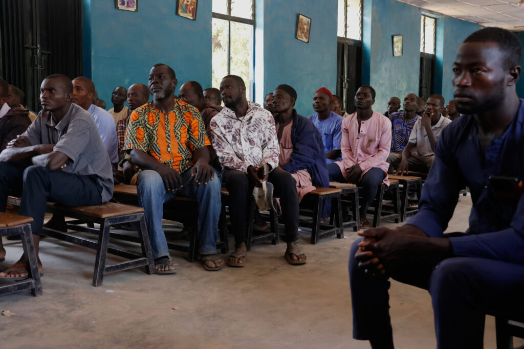
100 schoolchildren abducted in Nigeria are released but more are still held
Associated Press
associated-press@denvergazette.com
Updated 2 hours ago
MINNA, Nigeria (AP) — A total of 100 of the schoolchildren abducted from a Nigerian Catholic school last month have been released, the Christian Association of Nigeria said Monday, adding that more than 100 students remain in captivity. At least...
Associated Press
Reporter

Trump to announce $12 billion farm aid program
Washington Examiner Staff, Washington Examiner
washington.examiner.staff.washington.examiner@gazetteedit.wpenginepowered.com
Updated 2 hours ago
President Donald Trump is expected to announce a $12 billion farm aid program on Monday. The plan to provide aid to the nation’s farming industry comes as many have endured financial hardship due to low crop prices, the fallout associated...

Colorado Gives Foundation turns 50 during giving season
Kyla Pearce
kyla-pearce@denvergazette.com
Updated 3 hours ago
Colorado Gives Day is Tuesday. The Colorado Gives Foundation, which started as a small hospital fundraising group and has grown into a statewide nonprofit, is celebrating its 50th anniversary shortly after Giving Tuesday. Colorado Gives Day, which was created by...
Kyla Pearce
Reporter
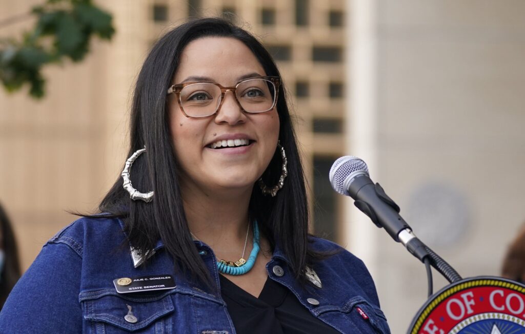
Colorado Democrat Julie Gonzales launches US Senate primary challenge to incumbent John Hickenlooper
Ernest Luning
ernest-luning@denvergazette.com
Updated 21 minutes ago
Declaring that Colorado “needs a fighter, not a bystander,” state Sen. Julie Gonzales, a Denver Democrat, on Monday launched her long-anticipated primary challenge to U.S. Sen. John Hickenlooper. Pitching her campaign as a departure from “old-playbook politics,” Gonzales said she’s...
Ernest Luning
Reporter
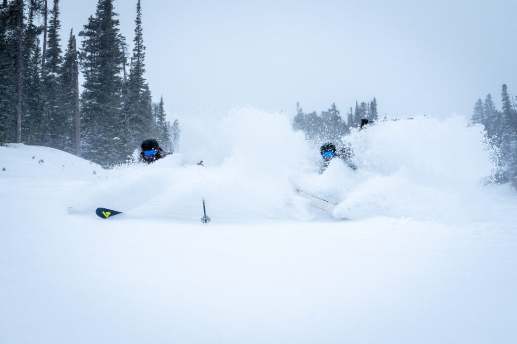
Large weekend storm drops 33″ of snow at one Colorado spot, snowpack doubles over 7 day stretch
Jonathan Ingraham
jonathan.ingraham@denvergazette.com
Updated 5 hours ago
The first big snow storm of winter 2025-26 for Colorado dropped about 10-20 inches in the northern mountains, 8-14 inches in the central mountains and 3-8 inches in the southern mountains. Colorado’s snowpack doubled in both median average and snow...
Jonathan Ingraham
Reporter
Denver weather: More melting on Monday as temperatures climb
Jonathan Ingraham
jonathan.ingraham@denvergazette.com
Updated 6 hours ago
Melting snow will continue Monday across metro Denver as the sun is forecast to come out in full as temperatures push into the 50s today. Denverites can expect sunny skies, with a high near 53 today, according to the National...
Jonathan Ingraham
Reporter

Democrat Shannon Bird to step down from Colorado legislature to campaign full-time for Congress
Ernest Luning
ernest-luning@denvergazette.com
Updated 3 hours ago
State Rep. Shannon Bird, a Westminster Democrat, said Sunday that she plans to resign from the Colorado legislature next month in order to focus on running for the 8th Congressional District seat held by Republican U.S. Rep. Gabe Evans. Bird...
Ernest Luning
Reporter
PREV
PREVIOUS

Denver officer justified in shooting that injured man during fireworks response, DA says
The district attorney’s office determined the actions of a Denver police officer who shot and injured a man during a fireworks violation was justified. Denver District Attorney John Walsh announced Monday the office won’t file charges against Denver police officer Michael Roake, according to a Denver district attorney news release Monday. Officials said on July […]

Robert Redford, the Oscar-winning actor, director and godfather for independent cinema dies at age 89
Robert Redford, the Hollywood golden boy who became an Oscar-winning director, liberal activist and godfather for independent cinema under the name of one of his best-loved characters, died Tuesday at 89. Redford died “at his home at Sundance in the mountains of Utah — the place he loved, surrounded by those he loved,” publicist Cindi Berger […]