


Two chances for snow in Colorado during first full week of January, 8-16″ possible
Snow is back in the forecast for Colorado, with two moderate storms bringing precipitation to all three mountain zones over the next five days.
Colorado’s snowpack is still hurting, but Mother Nature is chipping away at the deficit some, however, it is still in a rough spot at only 62% of median average.
Another multi-day sunny and dry period is on the horizon for the second full week of January, but the forecast isn’t all doom and gloom.
Recap:
Saturday and Sunday were very mild and sunny in Colorado’s high country, although some windy conditions existed Sunday across the Front Range and in Summit County. A wind gust of 70 mph was recorded at the Peak 6 summit at Breckenridge on early Sunday morning (6 a.m.) and again at mid-afternoon (3 p.m.) and a wind gust of 45 mph was recorded at the Eagle Wind summit at Winter Park.
The high temperature in Copper Mountain on Saturday was 38 degrees and on Sunday it was 40 degrees. The high temperature at Wolf Creek on Saturday was 41 degrees and on Sunday was 39 degrees.
Colorado snowpack:
Colorado’s snowpack has grown a bit over the last week, up from a pre-New Year’s Eve level of 57% of median average on Dec. 29 to 62% of median average on Jan. 4 and is a 4.2 inches of snow water equivalent, which is 2.5 inches below the snow water equivalent average of 6.7 inches for Jan. 4’s date.

For comparison, on Jan. 4, 2000, Colorado’s snowpack was at 62% of median average and held 3.9 inches of snow water equivalent within the snow. Winter 2000 ended slightly below median average, however, only time will tell if winter 2026 can follow 2000’s trajectory and not nose dive like winter 2002, which was the worst snowpack year in Colorado’s recorded snowpack history.
Forecast:
On Monday, snow began developing overnight and into the morning in the western, northwestern and northern mountains. The forecast calls for snow to continue through Monday night, ending overnight Tuesday for some fresh powder for most northern and some central and southern mountains ski areas.
Forecasted snowfall totals in the northern mountains are between 3-8 inches, in the central mountains between 3-7 inches and in the southern mountains between 1-5 inches but most of that snow could stay north of the northern San Juan Mountains even, giving only the Uncompahgre Mountains fresh flakes.
Tuesday and Wednesday are forecast to be dry and sunny while the state is between another storm system arriving Wednesday evening. This storm is trending toward being a bigger snow maker as well as all three mountain zones getting in on the action, including Denver, Fort Collins and Colorado Springs.
Snow is forecast to fall from Wednesday evening through early Friday morning, with both Thursday and Friday being pseudo-powder days, especially the farther west one travels along Interstate 70, US 40 and Colorado 82. This storm is forecast to be colder than the beginning-of-week storm as its approach from the northwest on a trailing arm from the main low pressure system carrying it will pull some colder air southward into Colorado from the northern Plains.
Additional snowfall totals in the northern mountains are forecast to be between 5-8 inches, in the central mountains between 7-11 inches and in the southern mountains between 5-9 inches.
Possible flurries along the eastern side of the Continental Divide in the Front Range Mountains are possible from Friday to Saturday morning, with another trace-1.5 inches recorded as the storm exits the state completely.
Long-term forecast:
Starting Saturday another long, multi-day dry period is trending again for Colorado as the polar jet stream keeps any potential storms north of Colorado until around Saturday, Jan. 17. One saving grace the weather models are showing during this period is colder air sticking around each day more or less, meaning minimal snow melt is possible due to low sun angle, short days, and colder air at both the snow surface level and in the air.
More model runs will need rendering to dial in better details about this forecasted time period, but currently this forecast offers up the coldest temperatures overall during winter 2025-26 so far.
Colorado ski resorts 24-hour totals:
Arapahoe Basin – 0″
Aspen Highlands – 0″
Aspen Mountain – 0″
Beaver Creek – 0″
Breckenridge – 0″
Buttermilk – 0″
Cooper – 0″
Copper Mountain – 0″
Crested Butte – 0″
Cuchara – 0″
Echo Mountain – 0″
Eldora Mountain – 0″
Granby Ranch – 0″
Hesperus – Closed for the season
Howelsen Hill – 0″
Kendall Mountain – 0″
Keystone – 0″
Loveland – 0″
Monarch – 0″
Powderhorn – 0″
Purgatory – 0″
Silverton –
Snowmass – 0″
Steamboat – 0″
Sunlight – 0″
Telluride – 0″
Vail – 0″
Winter Park – 0″
Wolf Creek – 0″
Ski patrollers end strike against Telluride
RACHAEL WRIGHT Special to The Gazette
rachael-wright-special-to-the-gazette@denvergazette.com
Updated 5 hours ago
After 13 days, the longest ski patrol strike in U.S. history has come to an end. On Dec. 27, the 72-member Telluride Professional Ski Patrol Association voted to go on strike after approaching Telluride Ski Resort (Telski) owner Chuck Horning...
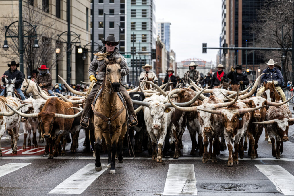
National Western Stock Show takes to the streets of Denver
Michael Braithwaite
michael.braithwaite@gazette.com
Updated 6 hours ago
After weeks of spring-like temperatures, the sky gave way to clouds and snow flurries Thursday morning. For those parking their trailers and brushing their horses in the parking lot of a dormant Coors Field, that sudden shift in weather could...
Michael Braithwaite
Reporter
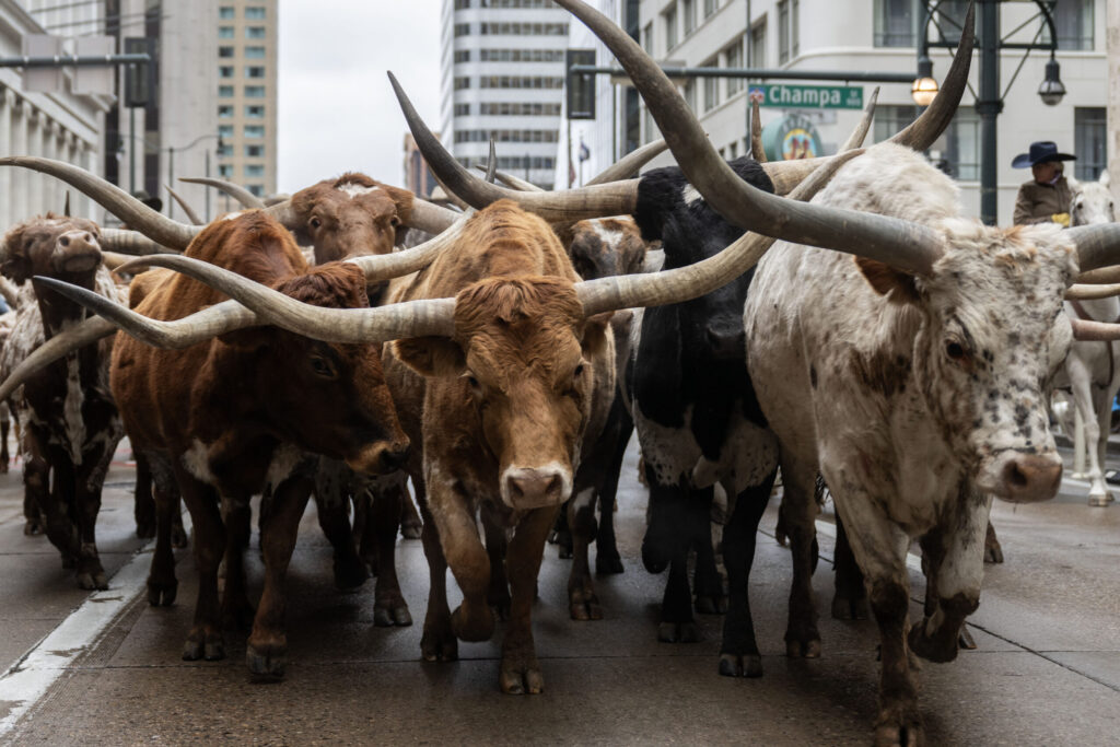
PHOTOS: National Western Stock Show Kickoff Parade in Denver
Stephen Swofford
stephen-swofford@denvergazette.com
Updated 7 hours ago
Stephen Swofford
Reporter

Senate advances war powers resolution on Venezuela
Mary Shinn
mary-shinn@denvergazette.com
Updated 8 hours ago
The Senate advanced a measure to block the use of troops in Venezuela Thursday morning. The measure was approved on a vote of 52-47, after five Republicans voted with Democrats, ensuring a later vote for final passage on the measure...
Mary Shinn
Reporter

House rejects effort to override presidential veto for Colorado Water Project
Marianne Goodland
marianne-goodland@denvergazette.com
Updated 5 hours ago
The U.S. House of Representatives on Thursday rejected a Colorado-led effort to override a Dec. 30 presidential veto of a measure that would have helped finance the Arkansas Valley conduit. The measure, known as H.R. 131 and sponsored by U.S....
Marianne Goodland
Reporter

House refuses to override Trump veto on Colorado water project as Republicans stick with president
Kevin Freking
kevin.freking@associatedpress.com
Updated 10 hours ago
WASHINGTON (AP) — The House refused Thursday to override President Donald Trump’s veto of two low-profile bills as Republicans stuck with the president despite their prior support for the measures. Congress can override a veto with support from two-thirds of...
Kevin Freking
Reporter
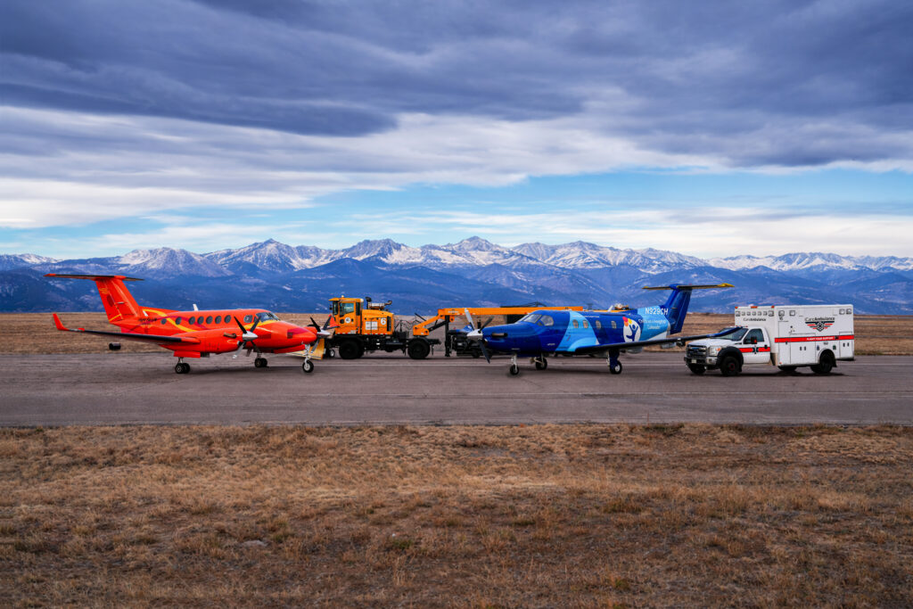
Centennial Airport announces new snow equipment to keep air ambulances in flight
Sage Kelley and Bernadette Berdychowski The Denver Gazette
sage.kelley@denvergazette.com
Updated 9 hours ago
It may not be a snowy season in metro Denver — yet — but the Centennial Airport is prepared. The airport, which houses multiple aircrafts for local hospitals and lifesaving organizations, announced the addition of two “state-of-the-art snow removal vehicles”...

Xcel seeks back-to-back rate hikes totaling $546 million
Scott Weiser
scott-weiser@denvergazette.com
Updated 5 hours ago
Colorado’s largest utility filed for major increases in both electric and natural gas rates within weeks of each other, a move that could add roughly $17 a month to the average household bill serving both services. Xcel Energy submitted a...
Scott Weiser
Reporter

Renee Good: What we know about the Colorado native killed in Minneapolis ICE shooting
News services
news-services@denvergazette.com
Updated 10 hours ago
The fatal shooting of Colorado Springs-native Renee Nicole Good by an Immigration and Customs Enforcement agent in Minneapolis has sparked public outcry across the country, with protests taking place nationwide and lawmakers speaking out against the incident. Good, 37, died...
News services
Reporter
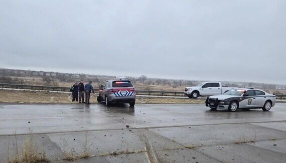
Police looking for driver who allegedly struck officer in Commerce City
Sage Kelley and Bernadette Berdychowski The Denver Gazette
sage.kelley@denvergazette.com
Updated 7 hours ago
A driver allegedly injured two Colorado State Patrol troopers Thursday morning near Commerce City before fleeing the scene. CSP was conducting a “team operation” on Interstate 76 near the Sable neighborhood around 9 a.m., according to a news release from...
PREV
PREVIOUS

Denver weather: Sunny skies, temperatures in the 60s Monday, but snow is on the horizon
Monday’s weather around metro Denver will continue to be above seasonal averages as high temps climb above 60 degrees again, however, a change to much cooler weather later in the week is coming. Denver residents can expect sunny skies, with a high near 62, according to the National Weather Service in Boulder. Breezy conditions will […]

To add a lane or not: I-270 proposal receives support, pushback
Traffic on Interstate 270, which connects U.S. Highway 36 and Interstate 70 in north Denver, often sits at a standstill. It doesn’t matter if its 10 p.m. on a Monday, 11 a.m. on a Wednesday or 2 p.m. on a Saturday. Almost no time of day or night gives reprieve from the traffic congestion to […]