




Ski area expected to get 45″ of snow over 5-day stretch in Colorado
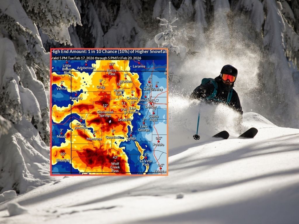
The most significant winter storm of the season thus far is underway in Colorado, with the National Weather Service calling for a potential of more than 48 inches of snow on some peaks.
Obviously, a winter storm of this nature is expected to have a major impact on the state’s ski areas, with double-digit snow totals expected at every spot around the state through the weekend. Perhaps most shocking, is the OpenSnow report that states that Wolf Creek Ski Area should get about 45 inches of snow between Tuesday and Saturday. As of February 17, Wolf Creek Ski Area reports 110″ inches of snow season-to-date, showing how significant an 45 additional inches of powder could be.
Wolf Creek is a front-runner by a longshot in terms of expected accumulation, with Purgatory and Crested Butte having the second and third-highest forecasted totals at 31 inches and 28 inches through Saturday, respectively (find the full resort-by-resort five-day snowfall prediction from OpenSnow here).
As far as outdoor recreation goes, it’s also worth noting that this storm will be a gamechanger when it comes to both high-elevation hiking and avalanche risk.
While many of the state’s fourteeners have accumulated much less snow compared to the typical season until this point, this week will change that. For example, the Maroon Bells is expected to get hit with 32 inches of snow through the end of Wednesday, per the Mountain-Forecast.com report. Most of Colorado’s high-elevation terrain will likely get at least a foot of snow and some places could get much more.
Two key hazards to watch out for will be a rapid uptick in avalanche risk, as well as poor driving conditions. The Colorado Avalanche Information Center website is already showing heightened avalanche concerns across most of the state, while officials are warning that many mountain passes could become treacherous. Wolf Creek Pass, for example, will likely get about 25 to 35 inches of snow this week in the most likely scenario – more like 43 inches if the National Weather Service’s ‘high-end’ scenario hits.
Given the dangerous conditions that will be present, it will probably be best for most outdoor recreators to postpone adventures until this weekend when there’s expected to be a lull in snowfall.
Follow along with the updated forecast on the National Weather Service website or find additional information about avalanche risk here – and remember, always check the avalanche risk forecast as close as possible to when you’re leaving the trailhead as this is subject to rapid change.
STAY INFORMED: Get free Colorado news with our daily newsletter (Click here)
Get OutThere
Signup today for free and be the first to get notified on new updates.
PREV
PREVIOUS

Weekly Weather Outlook for Colorado: February 17 through February 22
A winter weather system is set to move through Colorado this week, bringing significant snow and windy conditions to the mountains. Eastern Colorado and the Front Range could see strong winds and dry air, causing elevated fire danger. Temperatures will be cooler mid-week with the snow and wind, with the weather warming up towards the […]
RMNP announces temporary closures to protect nesting raptors
Rocky Mountain National Park (RMNP) has announced that temporary raptor closures are now in effect. Each year, RMNP officials initiate temporary closures in specific areas of the park to allow birds of prey to nest undisturbed. The closures will remain in place through July 31, but might be extended or rescinded depending on nesting activity. […]