




Did the big recent snowstorm improve Colorado’s drought? New map indicates ‘not by much’
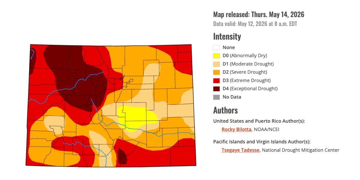
The U.S. Drought Monitor has released their first report following a snowstorm that dropped 30-plus inches of snow on some parts of Colorado last week and it indicates all of that moisture didn’t do much to improve Colorado’s drought situation.
Looking two weeks back, the entirety of Colorado was experiencing a technical stage of drought with close to 18 percent of the state experiencing drought stage four – the worst of four stages. Meanwhile, the Drought Severity and Coverage Index (DSCI) score was 366 – the highest it had been since February of 2021 with exception of the previous week when it was at 367. Per the drought report released on May 14, drought is now present in 96 percent of the state (a decline of four percent) and about 15 percent of the state is in drought stage four (a decline of three percent), which is improvement, but not much. The DSCI score is now 340, higher than where it was at the start of April and, excluding recent weeks, higher than its been since March of 2021.
There is a silver lining though – the portions of the state in drought stage two and drought stage three did decline, so while much of the state remains in drought and places where drought was the most severe are still very problematic, some parts of the state did benefit and are a little less dry. Keep in mind that the deepest totals of the recent storm favored northern Colorado in the area of Estes Park and Rocky Mountain National Park, thus the stage four drought that’s present in the state’s northwest quadrant didn’t get much relief.
One place that did get relief was El Paso County and Colorado Springs, which is now mostly considered ‘abnormally dry’ opposed to in drought. Teller County saw similar benefits.
Statewide snowpack has once again dropped to all-time-low levels, at 14 percent of the norm for May 14 and with a snow-water equivalent of 1.3 inches. This ties the record-low snowpack for the date. In a best case scenario, snowpack is still completely gone in Colorado around the start of June, which is about three weeks ahead of the norm.
Looking ahead, the National Weather Service is calling for a likelihood of warmer-than-normal temperatures in much of Colorado through at least June 5. Meanwhile, much of the state also has a likelihood of being wetter-than-normal during this period, too.
Pivotal Weather indicates that another couple rounds of snow could still be in store for Colorado this month, one from roughly May 18 to May 20 and another on May 27 to May 28. Mapping indicates this snow will be restricted to the mountains and considering the warmer-than-normal temperatures that may be present, too, we’ll have to wait and see how it pans out.
STAY INFORMED: Get free Colorado news with our daily newsletter (Click here)
Get OutThere
Signup today for free and be the first to get notified on new updates.
PREV
PREVIOUS

DUI suspect reportedly crashed into park ranger vehicles at Colorado state park
On Sunday night, Colorado Parks and Wildlife announced that an investigation was underway into a suspected DUI crash that occurred at Cherry Creek State Park. According to their report, the suspect allegedly crashed into multiple officer vehicles at the state park on the evening of May 10, with one wildlife officer transported to the hospital […]
Two waves of snow could bring 12-plus inches to some parts of Colorado
Despite the record-setting dryness of the winter season, it looks like the trend of springtime moisture is set to continue in Colorado – and the state might even get a bit more snow. Per mapping published by Pivotal Weather, snow flurries could start to hit some of the state’s peaks on Sunday, May 17, with […]